You must be logged in to view this content. Click Here to become a member of IndyWX.com for full access. Already a member of IndyWx.com All-Access? Log-in here.
Category: Arctic Cold
Permanent link to this article: https://indywx.com/quick-wednesday-evening-video-update-3/
Jan 27
Wednesday Morning Rambles…
January, to date, has been cold and dry, locally. Officially, Indianapolis is running 1° below normal and nearly 1″ below normal. After several relatively “boring” days, much more…
You must be logged in to view this content. Click Here to become a member of IndyWX.com for full access. Already a member of IndyWx.com All-Access? Log-in here.
Permanent link to this article: https://indywx.com/wednesday-morning-rambles-6/
Jan 22
Major Winter Storm Southeast to the Mid Atlantic…
A severe winter storm will track from the southeast today to the Mid Atlantic coast Saturday. Crippling snow will fall from the southern Appalachians northeast (the final product will be…
You must be logged in to view this content. Click Here to become a member of IndyWX.com for full access. Already a member of IndyWx.com All-Access? Log-in here.
Permanent link to this article: https://indywx.com/major-winter-storm-southeast-to-the-mid-atlantic/
Jan 21
Action To Our South; Relatively Quiet Here…
- Cold, dry, and increasingly windy
- Heavy snow across far southern IN
- Weak system Monday
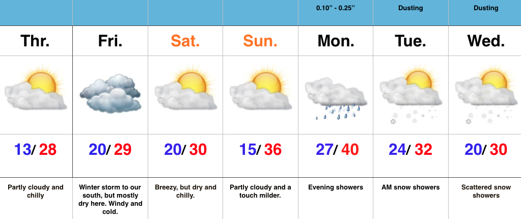
Watching A Major Winter Storm To Our South…As busy as things will be for our friends to our south and east, the weather, locally, will be about as quiet as we can expect this time of year. Hefty (and in some cases crippling) snows will fall to our south and southeast. Here on the home front we can expect a day with mixed clouds and sun today before we turn mostly cloudy Friday. We’ll feel the “outer impacts” of the major winter storm to our south Friday in the form of strong and gusty east winds that slowly begin to diminish Saturday. Sunday looks beautiful and it’ll feel downright balmy when compared to the bitterly cold air of late.
Our next weather maker is looking less and less impressive and will deal a few showers Monday followed by cold air returning Tuesday and Wednesday with scattered snow showers. – Doesn’t look like a big deal in the least from this distance.
Permanent link to this article: https://indywx.com/action-to-our-south-relatively-quiet-here/
Jan 20
Snowy Morning…
- Snowy morning
- Major winter storm impacts the southern Appalachians into the Mid Atlantic
- Dry, cold weekend in store
Snowy Morning; Next Winter Storm Shifts South…This morning’s snow “behaved” as planned with a quick thumping across a large portion of central IN. A quick scan of accumulation reports into the office this morning indicate amounts, on average, right around 2″ (some a bit more, some a little less). We’ll recap later this evening, with an overlay of our snowfall forecast map. Due to the timing of this event, this morning’s commute is a nightmare, as expected.
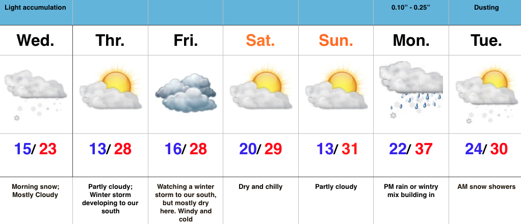
As we look ahead, the major winter storm (crippling for some) late week is trending further and further south. Now, instead of the initial low tracking through the TN Valley (which would’ve argued for a reflection of the low up west of the mountains), it appears to stay so far south that it tracks along the northern Gulf states before the primary low takes over and delivers the “snowy goods” to our friends from the east TN mountains north and east. By the way, this will be a monster event for the southern Appalachians (yard stick will be needed to measure the final product). Back here on the home front, we’ll forecast a dry, cold stretch with a blustery Friday (east winds gusting 20-30 MPH).
Our next weather maker of note will come early next week. More on that as we draw closer.
Safe travels and happy snow to all! 🙂
Permanent link to this article: https://indywx.com/snowy-morning/


