Category: Arctic Cold

Saturday Morning Rambles…

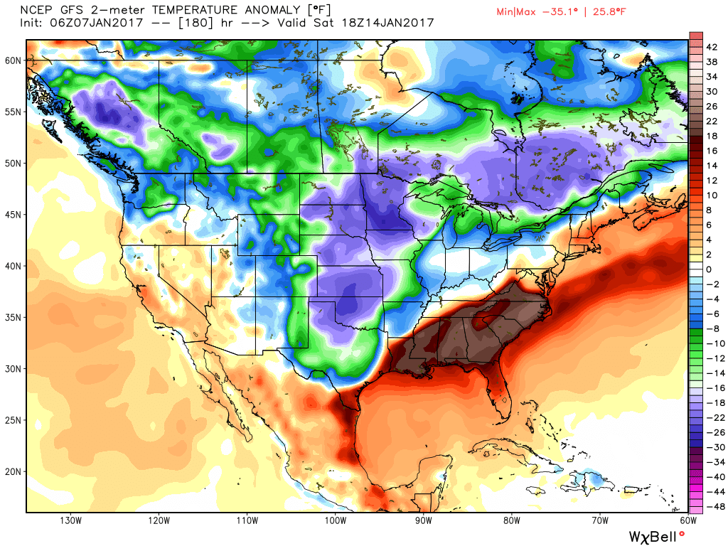
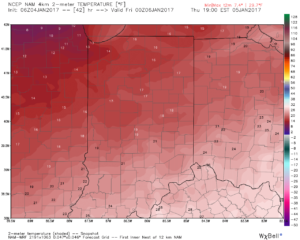
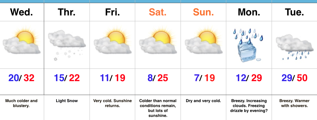
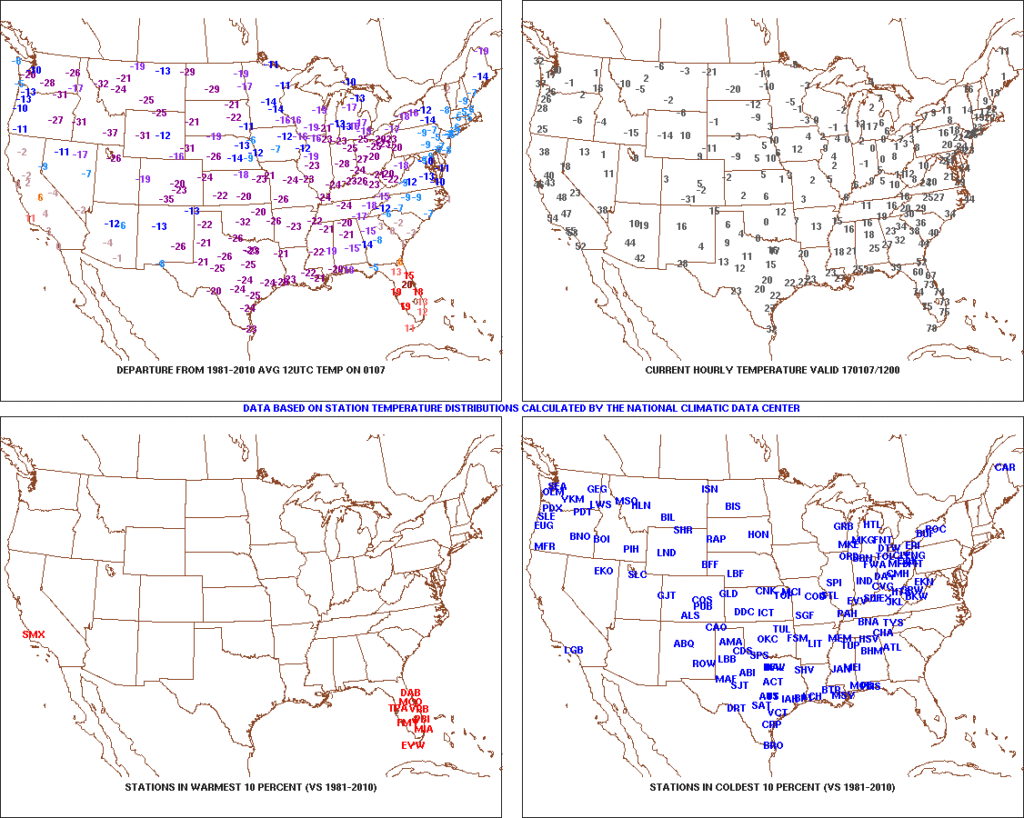
1.) Coast-to-coast cold:  The Lower 48 is waking up in an ice box this morning as widespread arctic air and below normal temperatures engulf the country (minus the FL peninsula this morning).  The arctic express will remain with us through the weekend, including temperatures once again tonight that threaten to dip into the sub-zero range across central Indiana.  Highs today will only reach the middle 10s and upper 10s to lower 20s Sunday.  Bundle up and stay warm.

t0
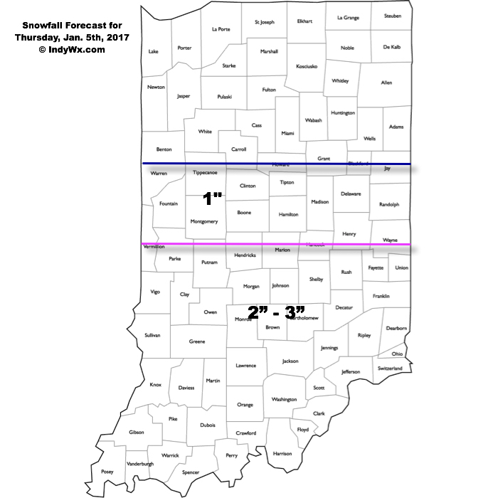
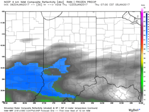
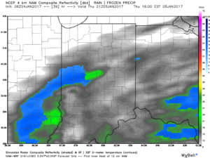
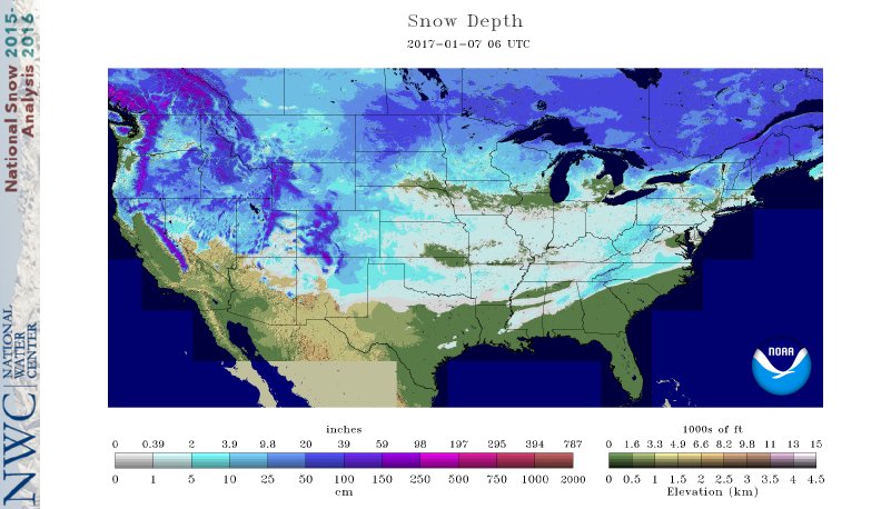
2.) Expanding Snowpack:  65.4% of the country is covered in snow this morning.  The cold, arctic high suppressed the winter storm threat south as we alluded to in previous posts.  Places across the Deep South that aren’t used to wintry precipitation are waking up to snowy and icy conditions this morning, including MS, AL, GA, SC, and into the Mid Atlantic.  Heavier snowfall accumulated across east TN, including 5″-8″ in the high country.  Heavy snow also fell through western and central NC and Blizzard Warnings are up in rare areas including VA Beach this morning.

nsm_depth_2017010705_national
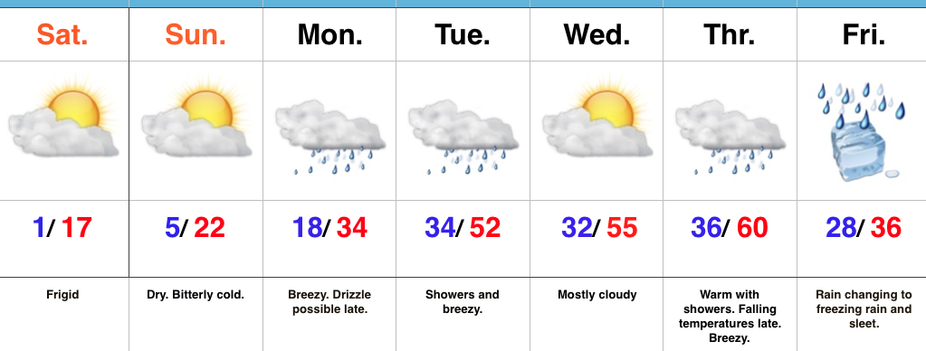
3.) Moderating Temperatures:  Our air flow will back around to the southwest and this will help temperatures begin to moderate early next week (around freezing Monday and all the way to around 50 Tuesday).  As the moderating trend gets underway, we may have to deal with a brief period of freezing drizzle/ freezing rain Monday evening.

gfs_ptype_slp_conus2_13
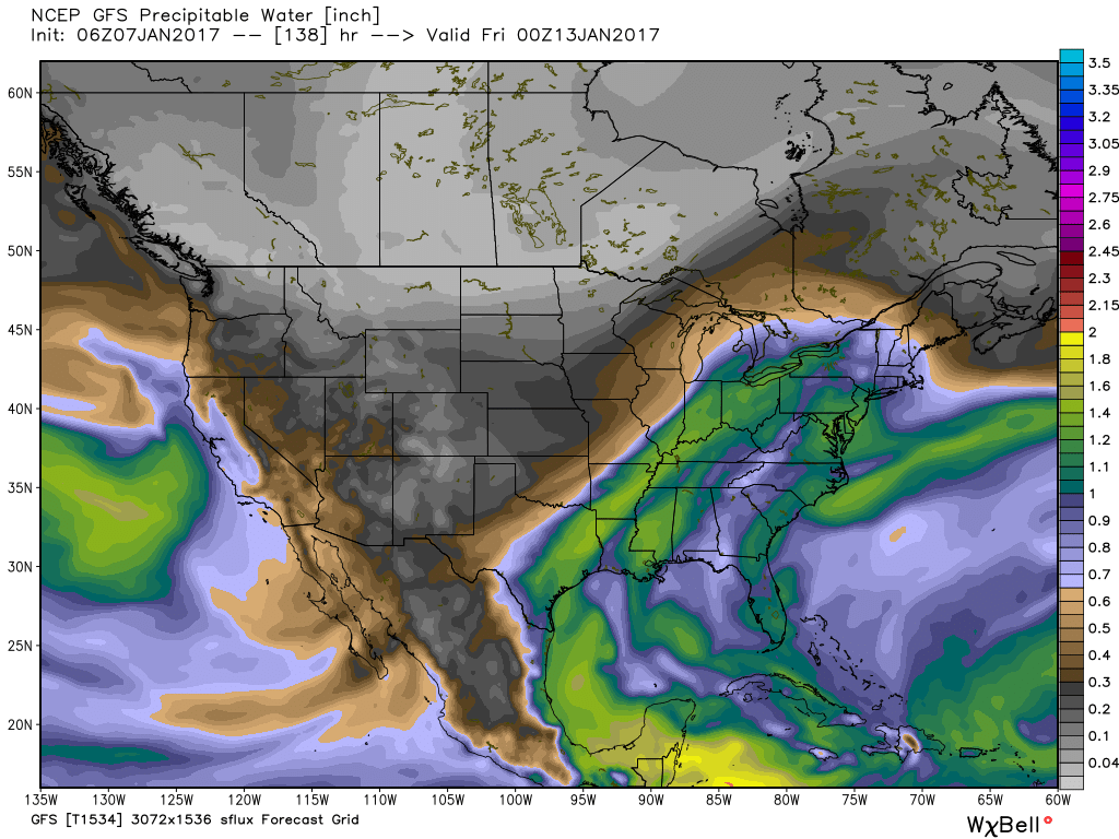
4.) Rainy Midweek:  A more significant surge of moisture will arrive midweek and result in periods of moderate to heavy rain Wednesday PM into Thursday.  Potential is present for 1″+ during this timeframe.

gfs_pwat_conus2_24
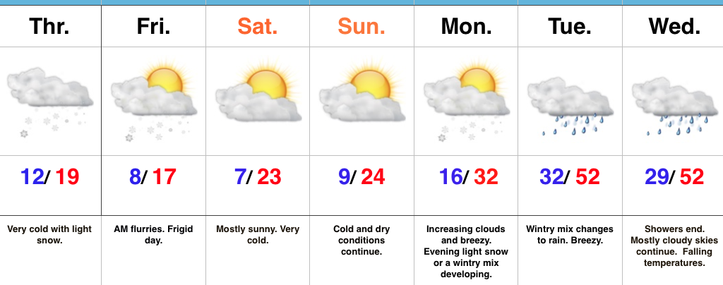
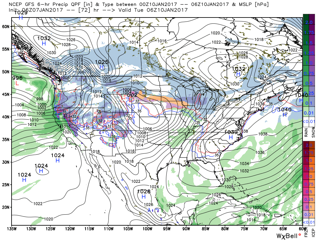
5.)  Weekend Wintry “Fun And Games?”  A tremendous battle will take place next weekend between a strong and sprawling arctic high pressure system and the southeast ridge.  In between it’ll be fascinating to watch things unfold, and as you’d imagine, that includes Indiana.  Despite the southeast ridge flexing it’s muscle, the concern here is that the shallow dense arctic air will “ooze” south and present an icy set-up for portions of the Ohio Valley and Mid West for the weekend.  We still have some time to watch this, but the potential of significant icing is very much present for some and this will require a close eye through the week.

gfs_t2m_a_f_conus2_31

Permanent link to this article: https://indywx.com/saturday-morning-rambles-9/

Bitter Weekend; Changeable Weather Next Week…

screen-shot-2017-01-06-at-6-33-47-pmHighlights:

  • Bitterly cold weekend
  • Big shift in temperatures next week
  • Icy set-up late next week?

Heavy Winter Gear Required…We’ll watch a significant winter storm impact the southern states this weekend with heavy snow and ice accumulations.  Here on the home-front, expect bitterly cold conditions with dry skies.  Clouds tonight should keep most areas around zero.  That’s frigid in and of itself, but should skies clear, temperatures will easily fall below zero.  Very cold conditions remain Sunday.

We’ll back our air flow around to the southwest early next week and this will help give temperatures a big boost by the mid week period.  Gusty southwest winds and showers will be with us, as well.

A complex weather pattern will set up to close out the week.  The clash of air masses between a sprawling strong arctic high and an equally impressive southeast ridge will be fun to watch, but not to forecast.  It’s very possible unseasonably warm conditions of Thursday give way to much colder weather going into next weekend as the arctic high helps “ooze” dense, shallow, cold air south.  At the same time, waves of low pressure will move along the pressing arctic front and periods of heavy precipitation will result.  Conditions should grow cold enough by Friday into Saturday for the precipitation to fall as an icy mixture of sleet and freezing rain across portions of central Indiana.  Stay tuned.

Upcoming 7-Day Precipitation Forecast:

  • Snowfall:  Trace
  • Rainfall:  1.50″ – 2.50″

Permanent link to this article: https://indywx.com/bitter-weekend-changeable-weather-next-week/

Snow Intensifies Again Early Afternoon; Turning Much Colder…

screen-shot-2017-01-05-at-9-24-44-amHighlights:

  • Snow intensifies for a period this afternoon
  • Bitterly cold weekend ahead
  • Moderating trend early next week

Snowy Thursday…Light snow developed during the predawn hours and made for a slick morning commute across central Indiana.   We note a steadier band of snow currently falling south of the city for places like Bedford, Columbus, and Seymour as of this update (9:30a).  As additional energy pushes across the state late morning into the afternoon, look for snow to expand in coverage and intensity for a time across more of central Indiana around lunchtime into the early afternoon before sliding off to the east.  Our ongoing snowfall forecast remains unchanged:

1517snowfallmap

Conditions will remain bitterly cold (most of today is spent in the 10s), and with even the slightest bit of snow cover, conditions will turn even more frigid to end the week.  Area-wide single digits can be expected to begin the day Friday (Saturday and Sunday, as well) with wind chills below zero.  Dry conditions return this weekend.  We’ll watch as our friends to the south enjoy a winter storm from Alabama, northern GA, into the Carolinas.

Moderating temperatures return early next week and as the warm advection begins Monday, it could help produce a wintry mix by evening before precipitation transitions to rain Tuesday, along with a breezy SW wind.

Upcoming 7-Day Precipitation Forecast:

  • Snowfall: 1″ – 3″
  • Rainfall: 0.75″ – 1.00″

Permanent link to this article: https://indywx.com/snow-intensifies-again-early-afternoon-turning-much-colder/

Snowy Thursday…

Snow will overspread central and southern Indiana during the predawn hours Thursday morning.  Snow, generally light, will continue into the afternoon, but there will be the potential of some localized banding to develop that will lead to higher snowfall rates mid morning into the early afternoon hours.  Thinking as of this morning is that the best potential of banding features will be found south of Indianapolis, but this is a fine line and won’t take much to “shove” that potential a couple county rows north.  We’ll keep an eye on it.

1517snowfallmapThis won’t be your standard 10:1 ratio type snow as conditions will be very cold throughout the day Thursday (only around 20 for a high).  This will serve to “fluff up” a tenth of an inch of liquid to a couple inches of snow very easily.  Secondly, with the cold conditions, it won’t take much snow to create slick and hazardous travel throughout central Indiana Thursday.  Please plan to allow plenty of extra time to reach your destination Thursday, both during the morning and evening commutes.

Forecast radar 7a Thursday.

Forecast radar 7a Thursday.

Forecast radar 4p Thursday.

Forecast radar 4p Thursday.

Temperatures will remain in the 10s most of Thursday.

Temperatures will remain in the 10s most of Thursday.

Temperatures will fall into the single digits Friday morning and highs Friday will only top out in the teens.

Make it a great Wednesday!  More later today!

Permanent link to this article: https://indywx.com/snowy-thursday/

Bitterly Cold Air Returns…

screen-shot-2017-01-03-at-4-31-46-pmHighlights:

  • Turning much colder tonight
  • Light snow Thursday
  • Bitterly cold, but dry weekend

The Ice Box Returns…An arctic cold front will sweep through the state tonight and help usher in a drastically colder feel as we progress through the middle and latter parts of the week.  Left over rain showers this evening may end as a couple of snow flurries before precipitation comes to an end.  Winds will really increase tonight behind the cold front, gusting between 30 and 40 MPH.  This will lead to single digit wind chill values out the door Wednesday morning.

Our next weather disturbance arrives Thursday morning and will help spread light snow across the southern half of the state.  Snow will continue into the early afternoon before departing off to the east.  Light accumulations (around 1″) will be possible, especially from Indianapolis and points south.  We’ll keep an eye on fresh data coming into the forecast office tonight and update if need be.

Otherwise, the big story going into the weekend will be the return of bitterly cold air.  In fact, overnight lows will drop into the single digits Saturday and Sunday mornings.  Dress warmly if you have plans to be outside for any length of time.

Our air flow will back around to the southwest early next week and temperatures will begin to moderate.  Moisture may make it to the surface to create a little spotty freezing drizzle Monday evening before temperatures sky-rocket to around 50 Tuesday as showers return.

Upcoming 7-Day Precipitation Forecast:

  • Snowfall: 1.00″
  • Rainfall:  0.25″ – 0.50″

Permanent link to this article: https://indywx.com/bitterly-cold-air-returns/