Category: Arctic Cold

Snowy Thursday…

Snow will overspread central and southern Indiana during the predawn hours Thursday morning.  Snow, generally light, will continue into the afternoon, but there will be the potential of some localized banding to develop that will lead to higher snowfall rates mid morning into the early afternoon hours.  Thinking as of this morning is that the best potential of banding features will be found south of Indianapolis, but this is a fine line and won’t take much to “shove” that potential a couple county rows north.  We’ll keep an eye on it.

1517snowfallmapThis won’t be your standard 10:1 ratio type snow as conditions will be very cold throughout the day Thursday (only around 20 for a high).  This will serve to “fluff up” a tenth of an inch of liquid to a couple inches of snow very easily.  Secondly, with the cold conditions, it won’t take much snow to create slick and hazardous travel throughout central Indiana Thursday.  Please plan to allow plenty of extra time to reach your destination Thursday, both during the morning and evening commutes.

Forecast radar 7a Thursday.

Forecast radar 7a Thursday.

Forecast radar 4p Thursday.

Forecast radar 4p Thursday.

Temperatures will remain in the 10s most of Thursday.

Temperatures will remain in the 10s most of Thursday.

Temperatures will fall into the single digits Friday morning and highs Friday will only top out in the teens.

Make it a great Wednesday!  More later today!

Permanent link to this article: https://indywx.com/snowy-thursday/

Bitterly Cold Air Returns…

screen-shot-2017-01-03-at-4-31-46-pmHighlights:

  • Turning much colder tonight
  • Light snow Thursday
  • Bitterly cold, but dry weekend

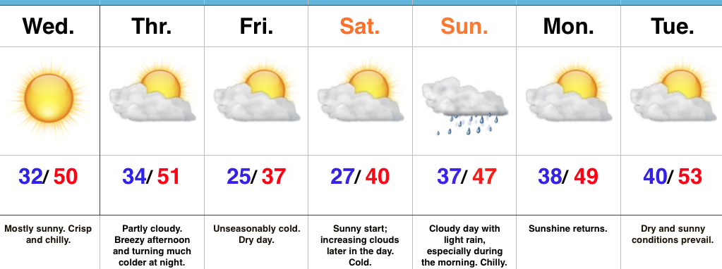
The Ice Box Returns…An arctic cold front will sweep through the state tonight and help usher in a drastically colder feel as we progress through the middle and latter parts of the week.  Left over rain showers this evening may end as a couple of snow flurries before precipitation comes to an end.  Winds will really increase tonight behind the cold front, gusting between 30 and 40 MPH.  This will lead to single digit wind chill values out the door Wednesday morning.

Our next weather disturbance arrives Thursday morning and will help spread light snow across the southern half of the state.  Snow will continue into the early afternoon before departing off to the east.  Light accumulations (around 1″) will be possible, especially from Indianapolis and points south.  We’ll keep an eye on fresh data coming into the forecast office tonight and update if need be.

Otherwise, the big story going into the weekend will be the return of bitterly cold air.  In fact, overnight lows will drop into the single digits Saturday and Sunday mornings.  Dress warmly if you have plans to be outside for any length of time.

Our air flow will back around to the southwest early next week and temperatures will begin to moderate.  Moisture may make it to the surface to create a little spotty freezing drizzle Monday evening before temperatures sky-rocket to around 50 Tuesday as showers return.

Upcoming 7-Day Precipitation Forecast:

  • Snowfall: 1.00″
  • Rainfall:  0.25″ – 0.50″

Permanent link to this article: https://indywx.com/bitterly-cold-air-returns/

Winter Having A Tough Time Finding Staying Power…

Through (5) weeks of meteorological winter, it’s been a frustrating time for snow and cold weather enthusiasts across the beautiful state of Indiana.  We’ve seen a few storms cut into the central Lakes, taking their respected snow swaths northwest of central Indiana.  Despite an “overachieving” arctic wave on the 13th and an icy glaze event the following Friday night, it’s been a rather uneventful winter so far.  In ironic fashion, a significant winter event is poised to impact portions of the Lower 48 this weekend, but the general consensus in modeling is for this event not to cut northwest, but, instead, remain suppressed and impact portions of the TN Valley and Southern Appalachians with heavy snow.  Now, sure, there’s still time for this to “correct” north, but as of this writing, there’s just as much argument in the suppressed idea.

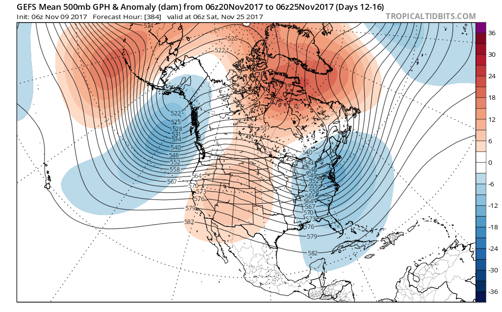
Admittedly, we, personally, believed we would be much farther along in the snowfall department than we are through the first 1/3 of meteorological winter.  Looking ahead, there really isn’t much to “like” about the longer term data as far as getting snow prospects. Sure, an arctic shot is still inbound come mid week with very cold air.  We note AK ridging and blocking “trying” to develop over Greenland.

gfs-ens_z500amean_namer_1This will take us through mid week and into the weekend with lows in the single digits and lower teens and highs generally in the lower and middle 20s.  We still need to watch Thursday evening-night for a wave of low pressure that may attempt to deliver light snow, but this doesn’t look like a significant event from this distance.

Additionally, we’ll keep a close eye on the weekend for the prospects of snow, but confidence remains very low in regards to this system.  The GFS ensemble members show the wide range of possibilities Saturday.  Taken verbatim, the respected (or not ;-)) solutions, range from “no snow for you” scenarios to a big hit.

gefs_ptype_ens_ky_22To further complicate matters, the European and Canadian solutions are much less robust and result in a more suppressed scenario.  Forecasters (including yours truly) can only wish for the days to return of worrying about respected snow/ mix/ rain lines amongst the various data, versus the present time of models showing a storm only to take it away from run-to-run and other modeling not even showing the storm.

But once to mid-month, the overall pattern is forecast to break down yet again and results in a much warmer look for the east.

gfs-ens_z500amean_namer_12That brings us to our next point and that’s the modeling performance, itself.  For really the better part of a year now, modeling has been poor, at best- even in the short-term solutions.  More recently speaking to the last few months, I can’t recall model data ever performing worse (13 years of forecasting experience).  It leads to a very low confidence forecast in basically anything beyond (7) days right now.  Additionally, conflicting signals are present (as posted this morning, the AO, EPO, WPO favor cold versus the MJO strongly favoring warmth in the longer range).  The signals are competing with themselves to try and take over the overall weather pattern for mid and late winter, but I’m not sure we’re really ever going to get to a point where we “lock-in” to any one particular warm or cold pattern for any sustained length of time this winter.  As far as snow goes, there’s no way in early January you’ll ever see us greatly alter the long-standing ideas posted originally in the winter outlook.  When a given city averages 26″ of snow on the winter, it only takes one storm to come along and put you in a “good spot” (relative to average).  That said, we hear your frustrations (and know they will only grow louder this weekend if our friends down south cash in on the snowy goods).  Once to late January, we’ll revisit this idea.

The one thing we try to do here is eliminate the “noise” in the short, mid, and long range data by analyzing it all and building a forecast using a blend of the said data, along with teleconnections, etc.  You’ll never see us update our forecast based on a model run every time in comes in.  We don’t buy into the idea of “knee jerk” forecasting.  Let’s sit back and watch the next few days unfold.  Unfortunately, in this weather pattern, we just don’t see confidence increasing in forecasts much past the 3-7 day window at this juncture.

Permanent link to this article: https://indywx.com/winter-having-a-tough-time-finding-staying-power/

Turning Colder After A Wet Open To The Week…

screen-shot-2017-01-01-at-7-25-02-pmHighlights:

  • Unsettled open to the week
  • Turning colder Tuesday
  • Couple snow chances, but low confidence

Wet Open To The Week…Clouds waited to increase until after sunset Sunday and the more than expected sunshine led to a downright beauty of a kickoff to 2017, complete with mild temperatures.  Unfortunately, those pleasant conditions won’t last as we deal with increasing coverage of showers and perhaps a thunderstorm Monday.  Rain coverage appears greatest during the evening into the nighttime hours.

An arctic cold front will sweep through the state Tuesday afternoon and lead to a dramatic temperature plunge for the rest of the week.  Showers Tuesday will end as a touch of wet snow before precipitation moves out.

Forecast models are still struggling with handling Pacific energy for mid and late week.  This is leading to a lower than normal confidence level with two potential systems Thursday and again Saturday.  For now, we’re eyeing the threat of light snow with both and believe modeling will come around to more of a weather maker once time draws closer.  Stay tuned.  Cold weather remains as we progress through next weekend.

Upcoming 7-Day Precipitation Forecast:

  • Snowfall: 1″ – 3″
  • Rainfall: 0.50″ – 1.00″

Permanent link to this article: https://indywx.com/turning-colder-after-a-wet-open-to-the-week/

Busy 7-Day To Usher In 2017…

screen-shot-2016-12-30-at-7-18-25-pmHighlights:

  • Raw New Year’s Eve
  • Briefly milder Monday with showers
  • Snow prospects mid week

Busy Times…Clouds will increase late tonight and give way to showers during the daytime New Year’s Eve.  Most of this shower activity will be light, but you’ll want to carry the rain gear with you as you leave for New Year’s Eve parties and celebrations throughout central IN.  Once to the nighttime hours, showers should diminish and most of the nighttime should feature rain-free conditions, along with colder temperatures.

New Year’s Day may start out with some sunshine, but clouds will increase through the day and drizzle or light rain is possible by evening.  Low pressure will track northeast from the central Plains into the upper Mid West Monday.  This will place Indiana in a relatively warm southwest flow.  Periods of showers can be expected through the day, along with breezy conditions.  An accompanying cold front will sweep through the state early Tuesday morning and shut rain chances off, shift winds to the northwest, and lead to falling temperatures.

Wednesday will be a day in between storm systems.  Cold high pressure will settle into the Ohio Valley and supply unseasonably chilly temperatures, but with sunshine.

Our next storm system will approach Thursday.  Clouds will increase Wednesday night and give way to an expanding snow shield during the day Thursday.  We still have a few days to look at things, but from this distance, the potential is present for an impactful wintry event across a widespread portion of the Ohio Valley, including central Indiana.  Stay tuned.  Fresh arctic air will move in to put a close on yet another short work week.

Upcoming 7-Day Precipitation Forecast:

Snowfall: 1″ – 3″

Rainfall:  0.75″ – 1.25″

Permanent link to this article: https://indywx.com/busy-7-day-to-usher-in-2017/