Category: Arctic Cold
 Highlights:
- Lake effect squalls this afternoon
- Another arctic shot early next week
- Light snow chances
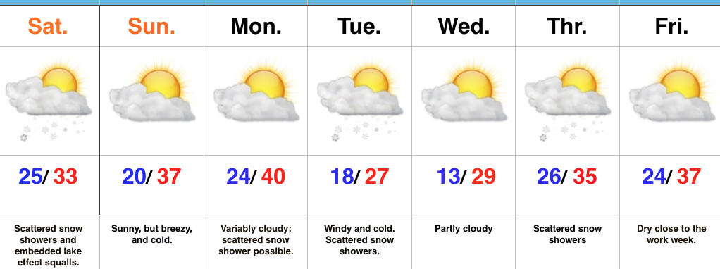
Hope You Like It Cold…Upper level energy is moving through the region this morning and is responsible for the scattered snow showers. Dry air “ate away” at the initial moisture and as a result we’re generally only looking at a dusting for most of central Indiana. The exception to that will be a narrow, but potentially intense lake effect snow band and embedded squalls that set up shop this afternoon. Under this band, an inch or two of snow will quickly accumulate.
Reinforcing cold, arctic air will pour into the state Monday night and Tuesday and will be accompanied by scattered snow showers. Another fast-moving disturbance will provide a shot of snow showers Wednesday night into Thursday.
All-in-all, no significant snow is on the horizon, but that may begin to change as Christmas nears. After brief moderation in the pattern next weekend, we’ll reload the cold pattern and likely see a stormy regime unfold, as well. Modeling suggests the southern stream will become more active in the weeks ahead…
Upcoming 7-Day Precipitation Forecast:
- Snowfall: 1″
- Rainfall: 0.00″
Permanent link to this article: https://indywx.com/cold-week-ahead-light-snow-chances/
 Highlights:
- Cold times
- First accumulating snow of the season
- Additional disturbances to monitor next week
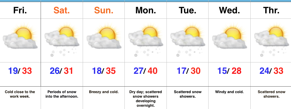
Snow Arrives Late Friday Night And Early Saturday…75% of our Thursday featured overcast skies and periodic flurries and light snow. Thankfully, a bit of drier air is working in to provide a brighter close to the day. A cold night is on deck as many fall into the teens.
A fast moving upper air disturbance will drop southeast into the Ohio Valley Saturday. This will help spread a swath of snow across central Indiana overnight Friday into the wee morning hours Saturday. Additionally, we’ll have to monitor the potential of enhanced lake effect bands across central and east-central portions of the state Saturday morning into the early afternoon. In general, we expect 1″ to 2″ of snow to accumulate across central Indiana, but note there may be a couple of heavier totals where lake effect bands set up.
Another fast-paced disturbance will blow into town Monday night into Tuesday, followed by another Wednesday night into Thursday. Cold weather will dominate through the period.
Upcoming 7-Day Precipitation Forecast:
- Snowfall: 2″ – 3″
- Rainfall: 0.00″
Permanent link to this article: https://indywx.com/fast-moving-northwest-flow/
You must be logged in to view this content. Click Here to become a member of IndyWX.com for full access. Already a member of IndyWx.com All-Access? Log-in here.
Permanent link to this article: https://indywx.com/video-first-stab-at-weekend-snowfall-totals-busy-winter-pattern-is-only-just-beginning/
 Highlights:
- Cold air settles in
- 1st accumulating snow of the season
- Active northwest flow pattern remains
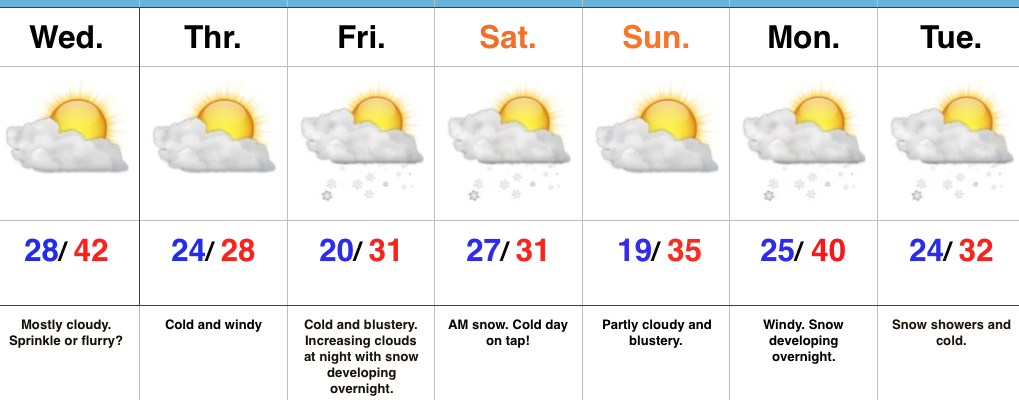
Unseasonably Cold…Northwest winds helped usher in a much colder air mass Tuesday behind an early morning frontal passage. While a couple of flurries are possible Wednesday, we’re mostly dry through the midweek stretch. We’ll notice resurgent cold and wind Wednesday night into Thursday. Heavy winter gear will be warranted.
Eyes will then turn to an approaching clipper system in what’s just the beginning of a busy northwest flow regime. We expect clouds to increase Friday evening and snow to develop overnight, continuing into the day Saturday. Given the dynamics in play, we still circle this period for the first accumulating snow event of the season. Sure enough, latest model data is also trending snowier during this timeframe. Another snow event looms late Monday into Tuesday with fresh arctic air drilling south early next week…
Upcoming 7-Day Precipitation Forecast:
- Snowfall: 1″ – 3″
- Rainfall: 0.00″
Permanent link to this article: https://indywx.com/cold-pattern-has-arrived-accumulating-snow-friday-night-saturday/
You must be logged in to view this content. Click Here to become a member of IndyWX.com for full access. Already a member of IndyWx.com All-Access? Log-in here.
Permanent link to this article: https://indywx.com/video-much-colder-busy-clipper-pattern/
 Highlights:
 Highlights:
 Highlights: