Category: Arctic Cold

Quiet Pattern Turns Much More Active As We Close March…

This week is about as boring as it gets around these parts in mid to late March. With the active pattern as of late, we’ll gladly take it.

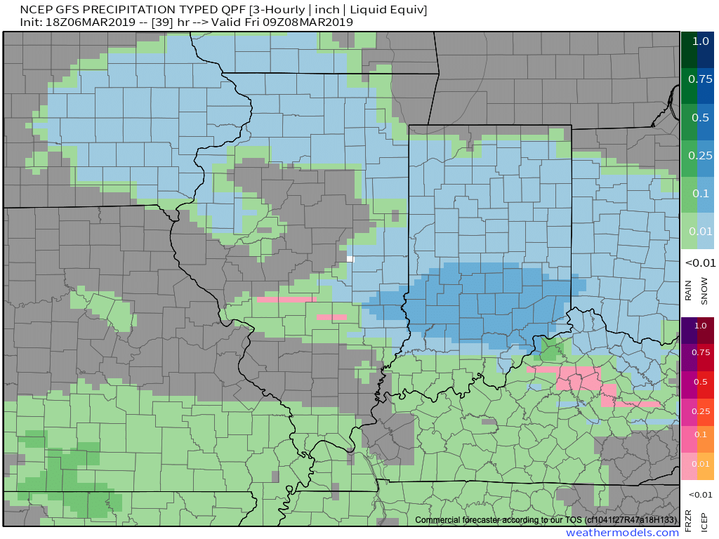
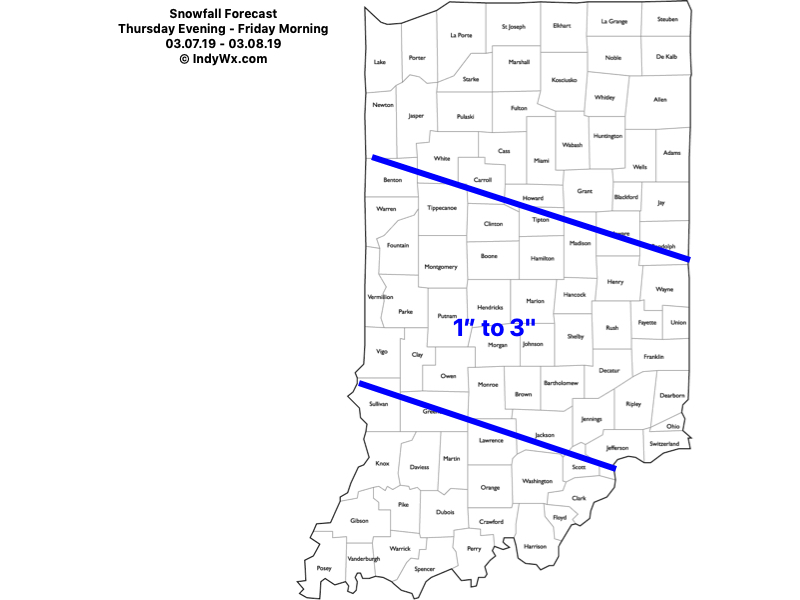
While we have a weak system that will deliver raw conditions and light rain Wednesday (touch of light snow and, or sleet across northern and east-central Indiana), that’s about it for “excitement” between now and early next week. High pressure will return as we get set to close the work week and head into the weekend, along with increasing sunshine and moderating temperatures. We still forecast highs to reach the 50s Thursday and Friday and 60s over the weekend.

It’d be wise to enjoy the “lull” in the action now, as things turn much more active as we flip the page forward to Week 2.

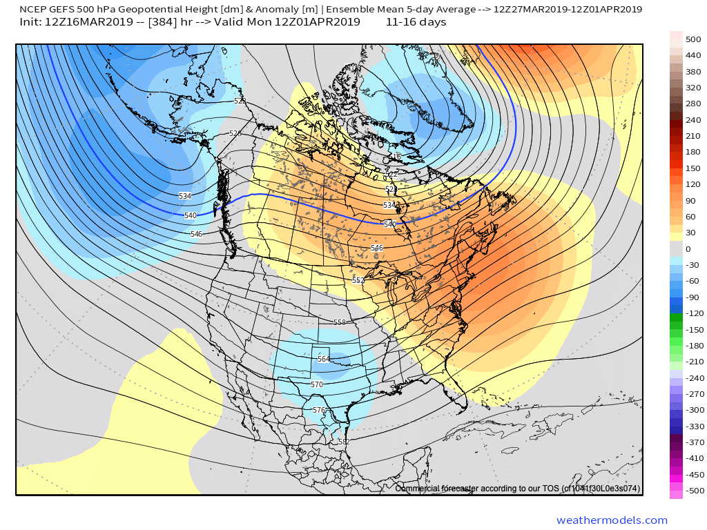
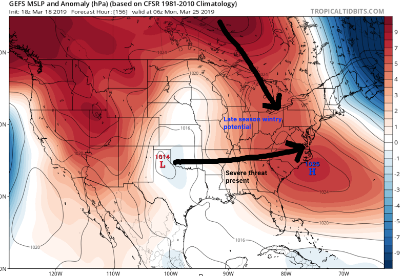
First up, in what will be a series of storm systems to impact the area as we close March and open April, will be a coast-to-coast storm that tracks east during the early portions of the Week 2 time frame. More specific to our area, this would likely be a system that begins to impact central Indiana during the early to middle parts of next week.

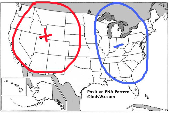
We’ve highlighted a couple of the items that have our attention, and if they come to fruition, will result in one more wintry “setback” before we say spring has officially sprung.

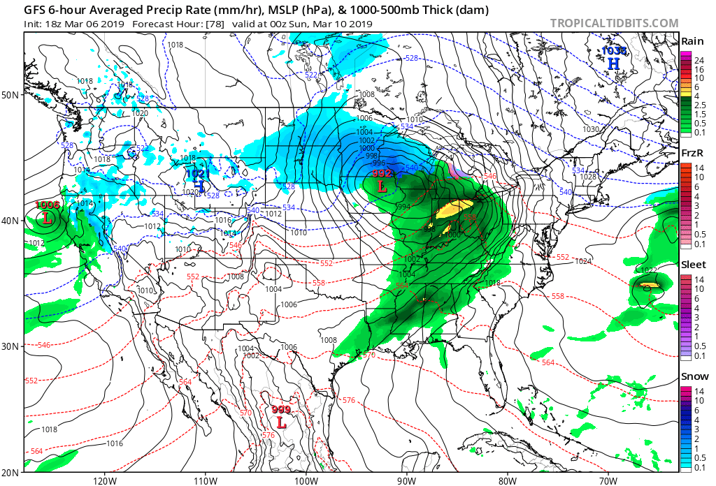
This is a bullish signal for an ominous spring storm, including the risk of severe weather to the south of the storm’s track and late season wintry potential to the north. It’s, obviously, far too early to get specific with this event, but it’s worth keeping a close eye on. Note that as the surface low (SL) is tracking east, a late season arctic high is pegged to be dropping southeast.

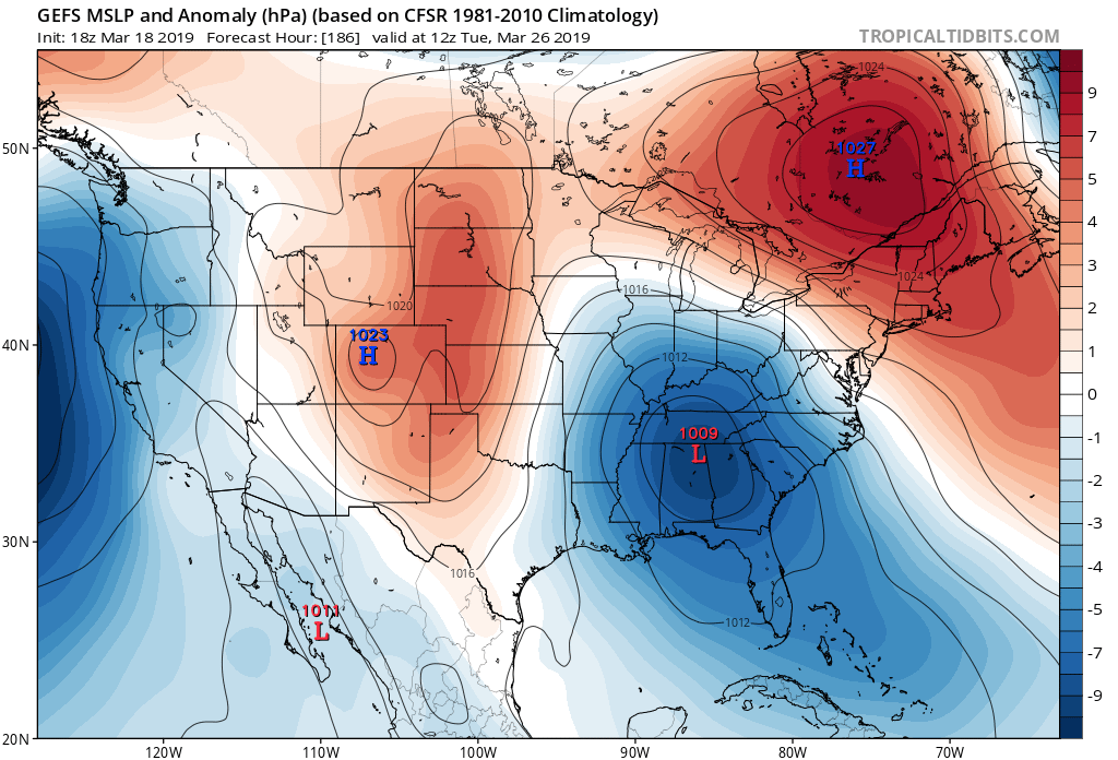
By the time we get to the middle of next Tuesday, the surface low is deepening across the TN Valley region. Despite the strong high nosing into New England, I’d expect a northward trend in the system as time gets closer, especially considering we’ll be in late March by this time. Stay tuned.

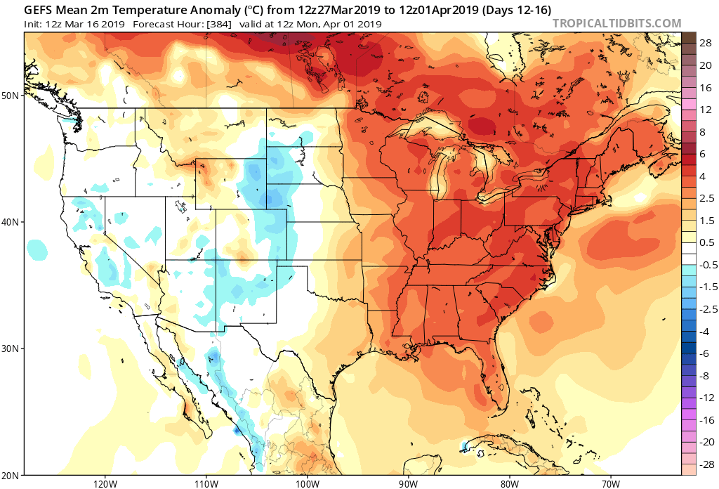
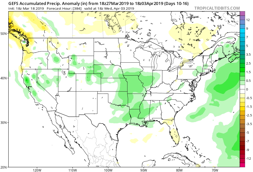
Thereafter, the pattern is set to remain quite active as we head into the 4th month of the year (2019 is flying by already). Buckle up; the well deserved quiet times now won’t last much longer…

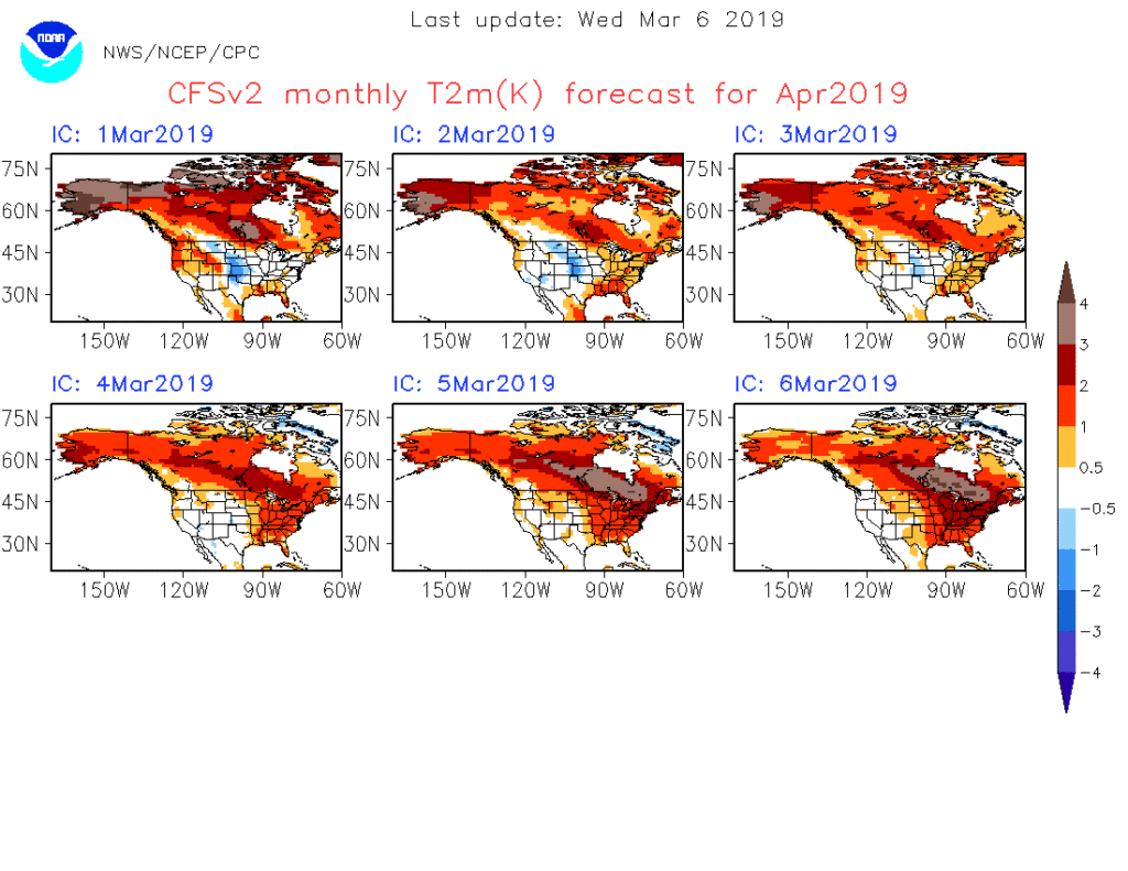
By the way, despite what may be one last push of wintry conditions early next week, data remains in excellent agreement of a significant warmup as we flip the page to April. We continue to believe the month, overall, will average above normal in the temperature department.

Permanent link to this article: https://indywx.com/quiet-pattern-turns-much-more-active-as-we-close-march/

Now We’re Talking…

Meteorological Spring has gotten off to a cold start- to the tune of nearly 5 degrees below average at IND through 3/15.

Note the brutal cold across the Northern Plains and Rockies.

The upcoming week will feature a positive PNA pattern and associated cooler than average theme to open, before beginning to moderate mid-to-late in the work week.

That said, time is limited on the chilly pattern and an overall significant shift to more of a sustained spring-like pattern awaits to close March and as we head into April.

Note the warmth that follows:

This will result in many more days in the 60s and 70s as we put a wrap on March and open April.

While weak systems will continue to impact the area (tomorrow, Wednesday, and again next Sunday), the deeper, moisture-laden storms will take a “backseat” during the fast-moving northwest flow. That begins to change during the last few days of the month and on into April. The latest ensemble guidance sees the return of a more active pattern, likely complete with heavier rain events and the potential of stronger storms.

Permanent link to this article: https://indywx.com/now-were-talking-4/

VIDEO: 50/50 Weekend; Closer Look At The Late March-Early April Pattern…

A quiet open to the weekend is replaced with accumulating snow for portions of the state Sunday…

You must be logged in to view this content. Click Here to become a member of IndyWX.com for full access.  Already a member of IndyWx.com All-Access?  Log-in here.

Permanent link to this article: https://indywx.com/video-50-50-weekend-closer-look-at-the-late-march-early-april-pattern/

Long Range Video Update: Changeable Pattern For The 2nd Half Of March Into April…

You must be logged in to view this content. Click Here to become a member of IndyWX.com for full access.  Already a member of IndyWx.com All-Access?  Log-in here.

Permanent link to this article: https://indywx.com/long-range-video-update-changeable-pattern-for-the-2nd-half-of-march-into-april/

Running the Gamut; Looking Ahead to April…

We’ll apologize in advance for the long-winded post tonight, but there’s a lot to cover. Not only do we have the accumulating snow on deck, a couple of strong storm systems this weekend into the middle of next week, but the long range pattern is set to turn cold (again) after a mid-month respite. We also want to look ahead to our early thoughts towards April…

Let’s take things one at a time:

Thursday-Friday Snow

While we don’t have major changes to our ongoing snowfall forecast, we have “sagged” the swath of 1″ to 3″ snow south just a hair given the latest computer model guidance. Steadiest snow should fall Thursday night into the predawn hours Friday. We’d anticipate a slick Friday morning commute through the heart of central Indiana.

Snow should exit off to the southeast around, or just before, lunchtime Friday. As always, your ground-truth reports are welcome (feel free to send to us on Twitter or via e-mail).

Warmer Side Of Things

The ‘mean’ trough position will shift to the west (temporarily) and lead to an overall milder time of things for the mid-month stretch. Unfortunately, the milder air will come with a wetter pattern.

This milder, wetter pattern will be highlighted by (2) storms:

I. Saturday, 3/10

II. Tuesday-Wednesday, 3/12-3/13

Both storm systems will be capable of producing locally heavy downpours and embedded thunder. Greatest chances of severe will remain south of central IN with this weekend’s storm, but may be further north next week. We’ll keep a close eye on things and issue Client Briefs if need be as we get closer.

A combination of the GFS and European computer models print-out rainfall totals between 1″ and 2″ over the upcoming 10-days and this seems reasonable given the fact both storm systems will be able to tap into Gulf of Mexico moisture.

From a temperature perspective, the brutal cold will come to an end behind our late week snowmaker. While “transient” chill will follow both of the upcoming storm systems, we’re heading into a much milder pattern, overall, through the mid-March stretch. Mildest air will come directly in front of the storm systems, highlighted by a couple of 60 deg. + days the middle of next week.

Positive PNA takes over

Unfortunately (for lovers of spring), the mid-month warm-up will be only a “tease” as we’re set to trend cooler, relative to normal, for the last 10 days of the month. The reason? A developing positive PNA.

To no surprise, we see the cooler pattern returning on the computer models:

Not only will we turn colder to close the month, but Thursday likely won’t be our last accumulating snow of the season…

Looking Towards April

Despite the late-March “set back” to a chilly time of things, we continue to think a more sustained “stick and hold” spring pattern looms around the corner. In fact, we agree with the latest CFSv2 delivering a warmer than normal pattern for April, as a whole, to the eastern portion of the country.

Note that as we go, the model is getting warmer for April with each passing day. As things stand now, we think the trough will pull back to the west with a more sustained ridge in place across the eastern portion of the country in April. With this, a wetter than average regime likely awaits, including an uptick in severe chances further north into the region.

Permanent link to this article: https://indywx.com/running-the-gamut-looking-ahead-to-april/