You must be logged in to view this content. Click Here to become a member of IndyWX.com for full access. Already a member of IndyWx.com All-Access? Log-in here.
Category: Arctic Cold
Permanent link to this article: https://indywx.com/video-timing-out-when-the-other-shoe-drops/
Dec 18
VIDEO: Snowstorm Review; Looking Ahead…
You must be logged in to view this content. Click Here to become a member of IndyWX.com for full access. Already a member of IndyWx.com All-Access? Log-in here.
Permanent link to this article: https://indywx.com/video-snowstorm-review-looking-ahead/
Dec 17
Looking Ahead To Christmas Week: Quiet; Warmer Than Average…
It’s been a whirlwind of a few days around these parts, but, thankfully for those with Christmas travel plans, that’s all about to change- at least from a weather stand point.
A cold front will sweep through the state Wednesday morning and we’ll get a glancing blow of arctic air midweek.

This, combined with a fresh snowpack, will result in many neighborhoods waking up Thursday morning to 10s, and a few single digit reports.

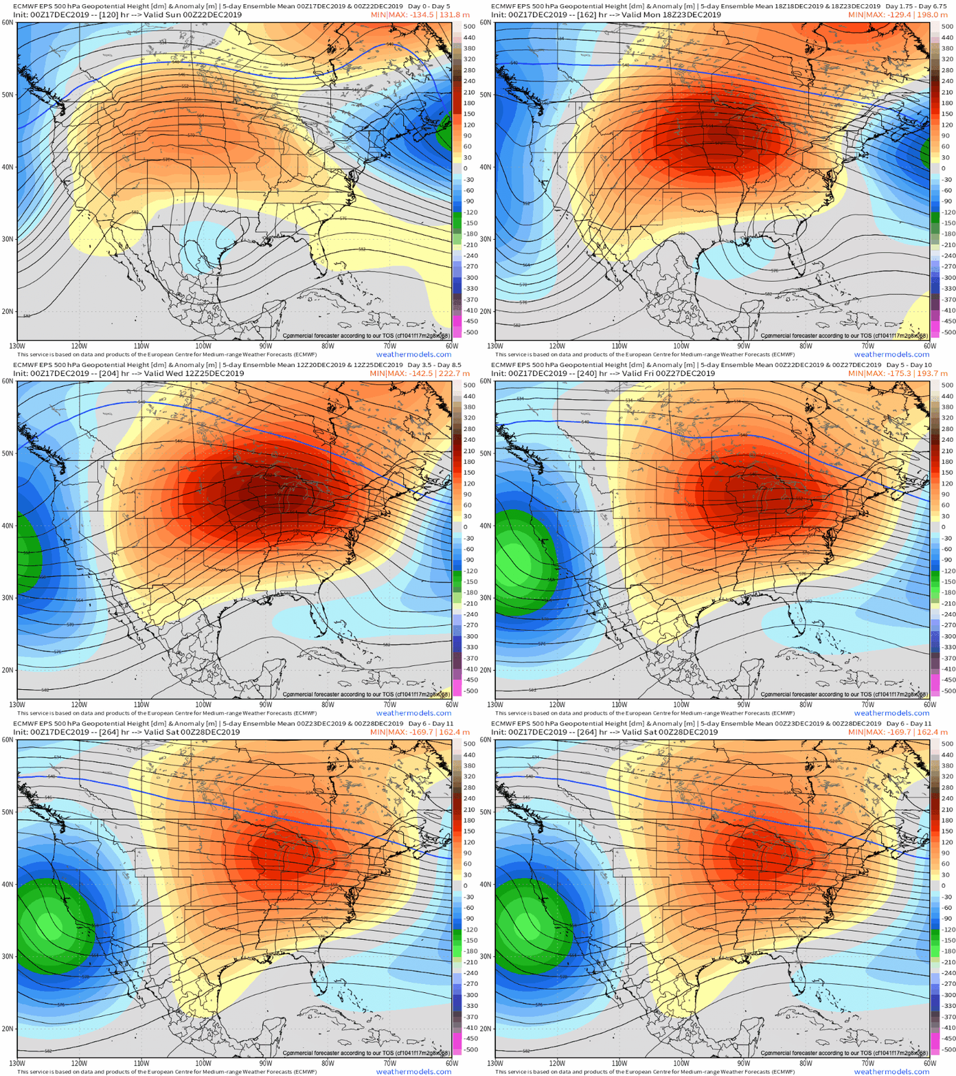
With us being on the “outer fringe” of this arctic airmass, we’ll quickly moderate back to “normal” mid-December cold late week and into the weekend. This will be a harbinger of things to come as Christmas week, itself, kicks off.
Note the expanding upper ridge from the Plains into the Ohio Valley and Great Lakes region.

This will do a couple of things: shove the energy that could have led to a weekend East Coast storm south and result in an unusually quiet and mild time of things, locally for the Christmas holiday.
In fact, with the exception of a couple light snow showers in association with Wednesday cold frontal passage, we’re talking about a precipitation-free stretch through Christmas Day. Not only will the active pattern come to an abrupt halt, but temperatures will begin to moderate to well above average levels by Christmas Eve and Christmas Day. Highs around the 50° mark are likely.
The next chance of meaningful precipitation just come just after Christmas and likely take the form of rain.
Permanent link to this article: https://indywx.com/looking-ahead-to-christmas-week-quiet-warmer-than-average/
Dec 13
Snow Arrives Sunday Evening; Latest Thoughts On Monday And Beyond…
After a dry and cold Saturday, weather will begin to deteriorate Sunday evening. We think snow will overspread central Indiana Sunday evening into Sunday night before transitioning to a wintry…
You must be logged in to view this content. Click Here to become a member of IndyWX.com for full access. Already a member of IndyWx.com All-Access? Log-in here.
Permanent link to this article: https://indywx.com/snow-arrives-sunday-evening-latest-thoughts-on-monday-and-beyond/
Dec 10
Light Snow Chances Wednesday; Something More Exciting Late Weekend?
You must be logged in to view this content. Click Here to become a member of IndyWX.com for full access. Already a member of IndyWx.com All-Access? Log-in here.
Permanent link to this article: https://indywx.com/light-snow-chances-wednesday-something-more-exciting-late-weekend/
