
You must be logged in to view this content. Click Here to become a member of IndyWX.com for full access. Already a member of IndyWx.com All-Access? Log-in here.
Category: Arctic Cold
Permanent link to this article: https://indywx.com/video-no-changes-to-the-idea-of-a-very-active-close-to-the-month-timing-out-storms-to-end-october/
Oct 16
VIDEO: Disruption In The Force, But Can We Get Our First Snowflakes Of The Season By Month’s End?
You must be logged in to view this content. Click Here to become a member of IndyWX.com for full access. Already a member of IndyWx.com All-Access? Log-in here.
Permanent link to this article: https://indywx.com/video-disruption-in-the-force-but-can-we-get-our-first-snowflakes-of-the-season-by-months-end/
Oct 10
Saturday Morning Rambles: Time To Pull Out The Heavier Cold Weather Gear…
Delta– the remnants of one time powerful Hurricane Delta will curl northeast into the TN Valley today and cross the southern Appalachians Sunday. Central Indiana will miss out on any…
You must be logged in to view this content. Click Here to become a member of IndyWX.com for full access. Already a member of IndyWx.com All-Access? Log-in here.
Permanent link to this article: https://indywx.com/saturday-morning-rambles-time-to-pull-out-the-heavier-cold-weather-gear/
Oct 06
What Can We Learn From A Persistent Negative October AO For The Upcoming Winter?
October has opened on quite a chilly note across not only central Indiana, but a good chunk of the eastern half of the country. Officially, Indianapolis is running 8.4° below average, month-to-date.

While warming will occur in the upcoming 7-day period, there are already seeds being planted for the return of unseasonably chilly conditions after this transitional warmth.
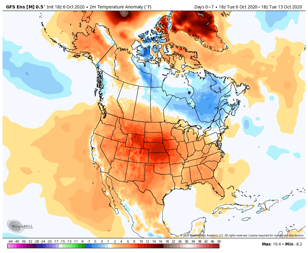
The pattern will take on signs that you’d expect from a positive PNA and trending negative EPO. That will pull the chill back into the east and we may just may trend wetter during the mid and late month period, as a series of cold fronts sweep through the region (fingers crossed).

The purpose of this post is to focus on the predominantly negative Arctic Oscillation (or AO) and what, if anything, we can learn for the upcoming winter. Note the AO continues a negative look over the upcoming couple weeks (it’s been negative so far this month, as well).

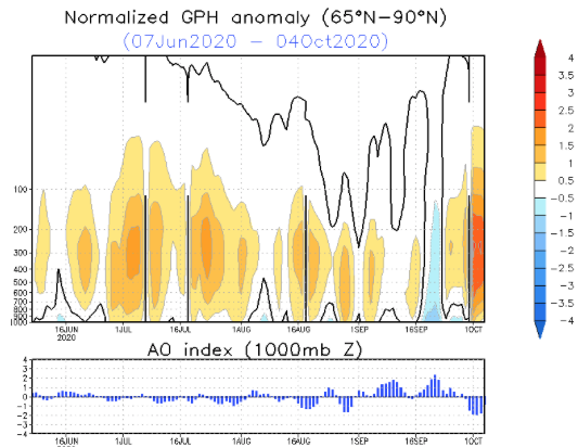
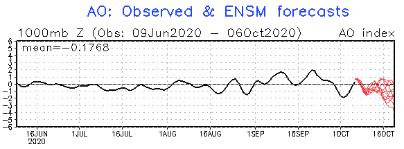
The combination of the persistent negative AO so far this month, along with what’s forecasted over the coming few weeks, got us interested to see what kind of patterns occurred during the following winter (Dec. through Feb.). We went back and looked at all October with a negative AO of 1, or more, since 1960 and this is what the analogs produced:
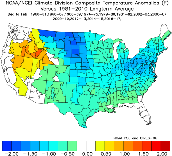

There’s obviously a lot of other ingredients we’ll factor into our winter outlook this year (per usual), but this is another interesting case study in front of us, especially with so many climate models blow torching the upcoming winter.
Our complete annual winter outlook will be online Sunday, November 1st.
Permanent link to this article: https://indywx.com/what-can-we-learn-from-a-persistent-negative-october-ao-for-the-upcoming-winter/
Sep 08
2 Sides To Every Storm…
An early taste of winter is descending on the Rockies today (the town of Breckenridge camera will be fun to check in on from time to time over the next 24 hours). Places, such as Denver, that were in the 90s yesterday will fall into the 20s and 30s today with snow.

Note the big spread in temperatures across the country this morning and corresponding 24 hour temperature change:


We’ll remain on the mostly dry and warm side of this event until the weekend.
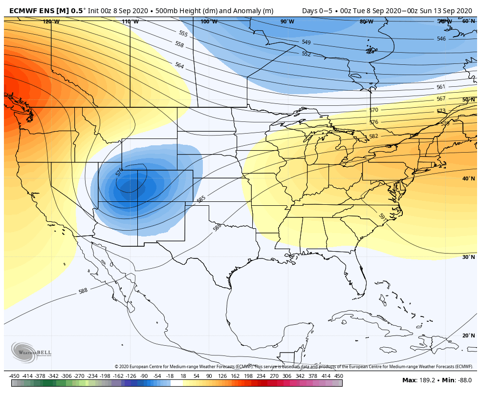
Once the storm system lifts northeast and gets close enough to impact our region, it’ll be in a much weaker state. Scattered showers and thunder are possible over the weekend, but widespread significant rainfall isn’t expected.
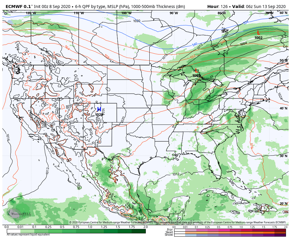
After heavy rains fell across north-central Indiana Monday, a much drier theme can be expected throughout the next several days. A widely scattered shower or thunderstorm is possible before Saturday, but most should remain rain-free. Even as the storm system draws closer, weekend rainfall should average only between 0.25″ and 0.50″ for most.

Cooler air (nothing to the extent or magnitude of what our friends out west are seeing) will filter in here late weekend and early next week. Lows into the 50s can be expected with a couple of days of highs in the 70s.
Permanent link to this article: https://indywx.com/2-sides-to-every-storm/