Updated 01.29.23 @ 5:35p
You must be logged in to view this content. Click Here to become a member of IndyWX.com for full access. Already a member of IndyWx.com All-Access? Log-in here.

Jan 29
Updated 01.29.23 @ 5:35p
You must be logged in to view this content. Click Here to become a member of IndyWX.com for full access. Already a member of IndyWx.com All-Access? Log-in here.
Permanent link to this article: https://indywx.com/video-light-wintry-precipitation-across-the-central-southern-portion-of-the-state-longer-range-pattern-update/
Jan 19
Updated 01.19.23 @ 6:15p
Our short-term products will continue to handle the snow threats this weekend and next week. In short, we have no changes to our thoughts on either of those from this morning. The 2nd storm has potential to be something much more significant, but we need to give it another 2-3 days before putting a forecast in concrete, especially this winter.
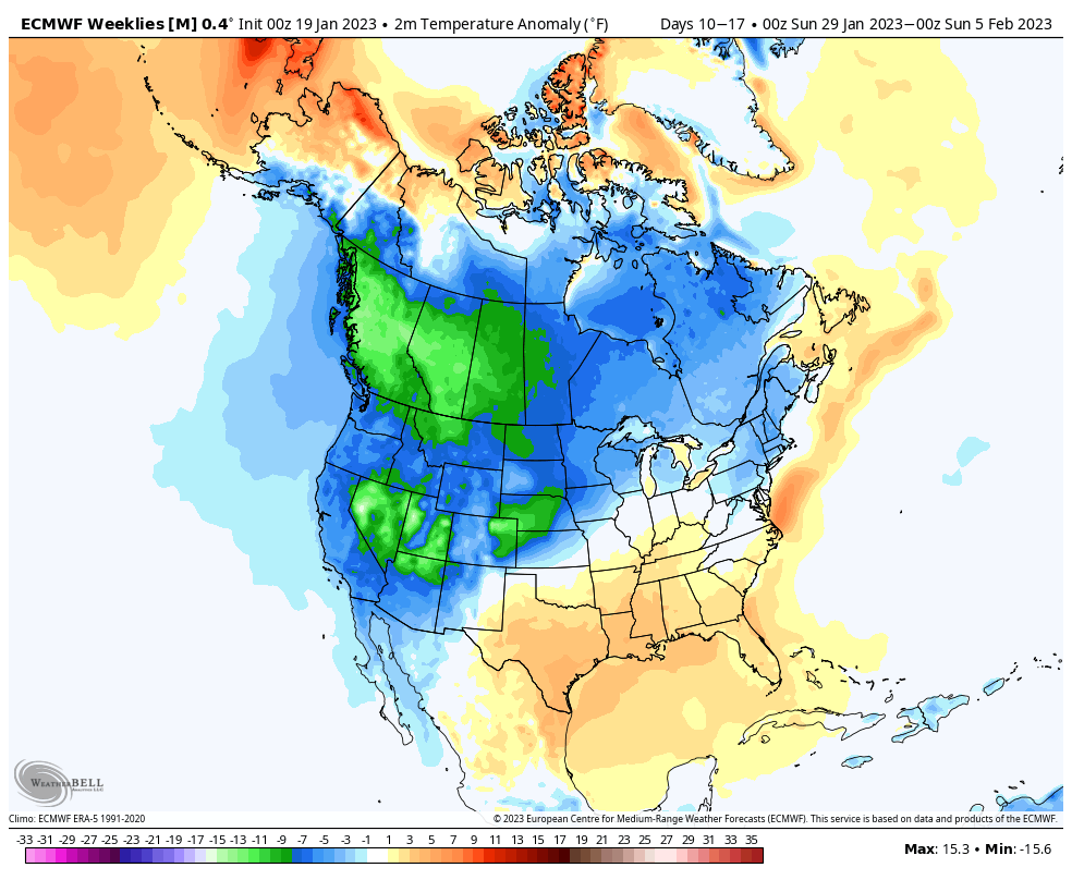
As for the longer range, a more seasonably cold brand of air is expected as we put a wrap on January, but I’m not willing to go further than that to suggest anything close to “bitter” cold is on deck- certainly given the time of the year. It’ll feel much colder, especially considering just how warm it’s been of late, but I just don’t see anything overly cold on the horizon, compared to normal.
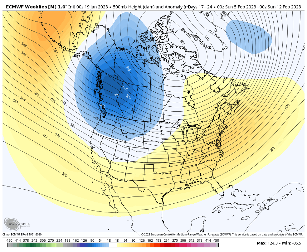
Thereafter, the pattern drivers suggest a warmer than normal pattern will return. “Transitional” anyone? While I can’t say we’re looking at anomalies as great as what we’ve seen so far in January, I do think early and mid February will feature above to well above normal temperatures before colder than normal trends take hold late February and into early March.
The updated European Weeklies mirror the new JMA Weeklies and we see no reason to argue given the movement and overall alignment between the EPO, PNA, NAO, and AO.
Week 2


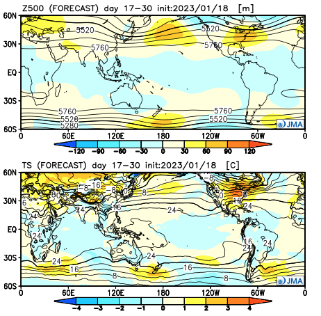
JMA Weeks 3/4
European Weeklies: Week 3
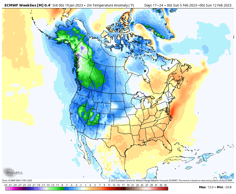
European Weeklies: Week 4
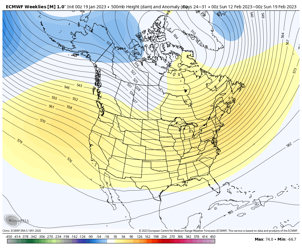

As we get out towards the latter part of February (around or after the 20th), the teleconnections mentioned above, that will likely promote the relatively warm conditions, will begin to turn around and drive a colder close to the month and open to March. In fact, there are signs the coldest anomalies of the entire winter (compared to average, not in the “absolute” form) will await for this period, and potentially continue into a good chunk of March, especially if the MJO amplitude continues and we add in a negative NAO. (I know, I know- remember that I’m only the messenger).
In the meantime, we also agree with the above normal precipitation pattern painted throughout the upcoming few weeks between the updated Weekly products.


In this active type pattern, despite the lack of bitterly cold arctic air, plenty of snow is likely still yet to fall this winter. In fact, despite the slow start, I wouldn’t be shocked if snowfall amounts end up being pretty dang close to seasonal averages with this type pattern (give or take a few inches). The ultimate irony will be if the bulk of that falls in March…
Much more in the morning around the Sunday and Tuesday-Wednesday snow threats!
Permanent link to this article: https://indywx.com/february-and-early-march-long-range-discussion/
Jan 01
Updated 01.01.23 @ 6:25p
You must be logged in to view this content. Click Here to become a member of IndyWX.com for full access. Already a member of IndyWx.com All-Access? Log-in here.
Permanent link to this article: https://indywx.com/video-new-years-update-on-the-short-and-longer-range-set-up/
Dec 26
Updated 12.26.22 @ 9:40a
It’s certainly no secret that a big thaw is ahead. As we set the bar with this current cold spell, we’ll set the bar for the upcoming period of warmth: minimum of (2) days of highs of 60°, or greater, between Jan. 1 and Jan. 5. It’s another case of a significant thaw following a bitter blast of arctic air. In researching classic arctic outbreaks of the past, this happens many more times than not.
In any event, we continue to see the relatively mild and wet pattern carrying us through the first week of January.

But seeds are already being planted for a renewed wintry spell. In particular, the teleconnections are bullish on cold returning around, or just after, Jan. 10. We note the longer range charts keep these pattern drivers in a favorable position for more of a prolonged period of cold, as well:

Forecasters have to love the overall alignment as this helps build medium to longer range confidence in the overall pattern progression.
Then we add in the MJO rumbling into Phase 7 for early January. While there will be a bit of a lag, this is another signal for a cold look across the eastern portion of the country, especially by that Jan. 10 time frame.


While I can’t say we’ll see another arctic shot to the magnitude of this current frigid regime, I am more confident than normal from this distance in the period that runs from Jan. 10 through Jan. 25 being colder than normal as a whole. I would anticipate the longer range modeling (Weeklies, in particular) becoming increasingly cold with updates this week during that aforementioned period.
More updates to come as we rumble through this holiday week…
Permanent link to this article: https://indywx.com/significant-thaw-ahead-but-bullish-on-winters-return/
Dec 16
Updated 12.16.22 @ 7:48a
You must be logged in to view this content. Click Here to become a member of IndyWX.com for full access. Already a member of IndyWx.com All-Access? Log-in here.
Permanent link to this article: https://indywx.com/lr-update-into-mid-january-short-term-focuses-on-accumulating-snow-prospects-next-week/