
Daily, we’re receiving questions around if and when winter will show up. While admittedly later than originally thought here, we’ve never been in the camp of “throwing the towel” in on winter. Our winter outlook that includes below normal cold and near average snowfall remains unchanged.
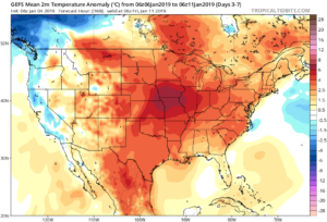
Before we get into some of our reasons why we think winter will show up (and likely make up for lost time), the upcoming week will remain much warmer than average.
We’re tracking (3) storm systems that will deal the region rain over the upcoming week:
- Southern IN this afternoon and evening
- All of the state Monday
- All of the state next Friday into Saturday
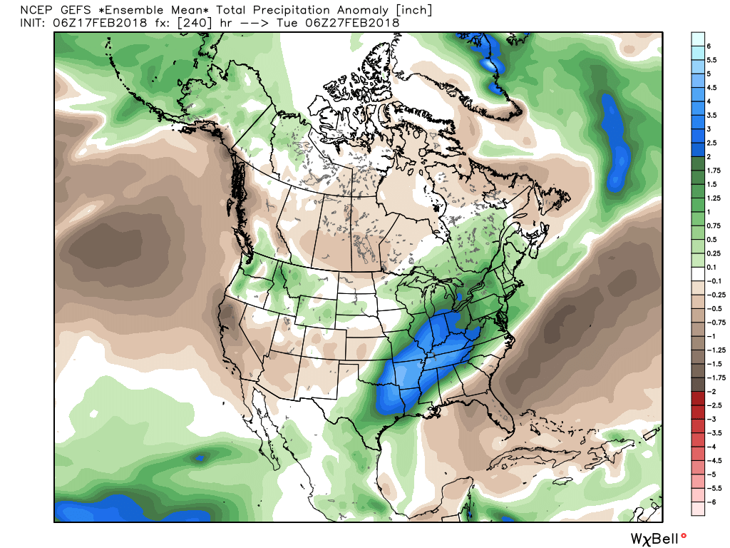
As a whole, rainfall amounts won’t be particularly impressive for most, with 7-day totals between 0.25″ to 0.75″ for central portions of the state. Heavier amounts can be expected across southern areas.

Now, let’s look ahead to some potentially colder times. Before moving forward, it’s important that we recognize models have attempted once already to drive in a wholesale pattern change to colder (originally thought to be underway now). Perhaps it’s a case of “delayed, but not denied.” There’s a lot going on behind the scenes:
- Sudden stratospheric warming event and potential polar vortex displacement, etc.
- SOI flipping from a Niña-like state to one we’d expect to see associated with an El Niño
- Active MJO remains
There are significant changes brewing in the arctic/ higher latitudes that have to raise an eyebrow at the very least.
Today
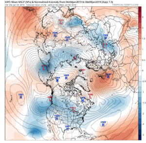
Mid-January
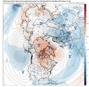
Note the higher pressures building over the upcoming 10-14 days in the arctic regions.
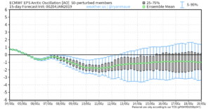
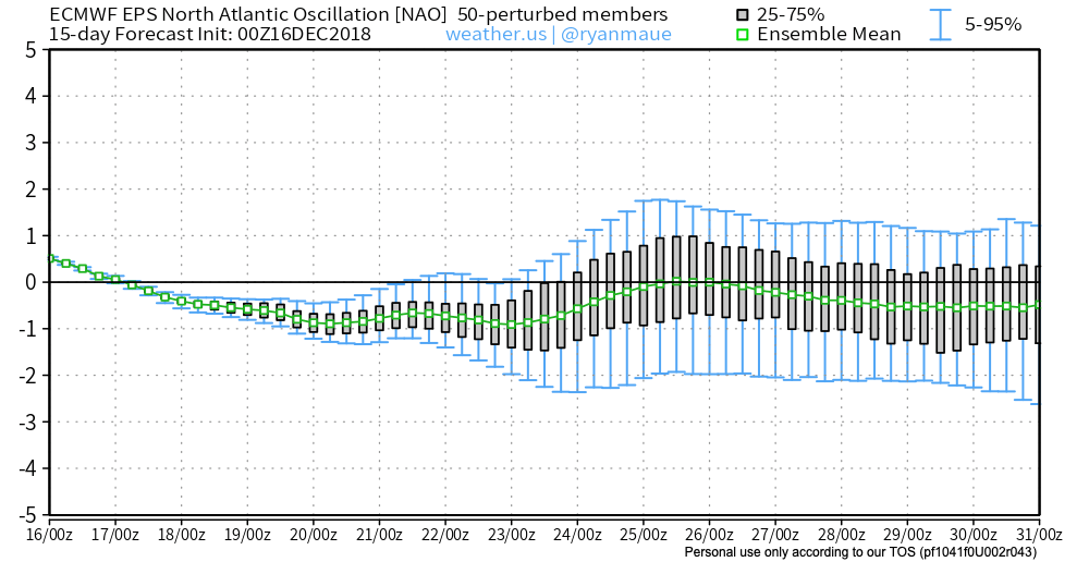
Not surprisingly, the models begin to tank the AO.
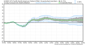
The PNA rises…
Something that also lends credence to a potential pattern shift is the recent SOI drop.
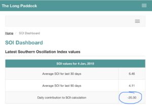
This would tend to suggest that an active storm track may be in place as the more bonafide cold shift is underway.
The moral of the story? Despite the milder period being extended a couple weeks longer than originally thought, there’s still a lot on the table this winter. It’s far too early to think winter’s over before it’s really even begun for most. We expect to see increasingly wintry conditions show up around the middle of January…
Stay tuned.


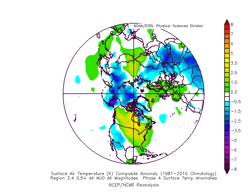
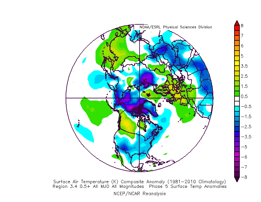
 The basis of our late-December forecast is built from the MJO, or Madden-Julian Oscillation. We note the MJO is expected to rumble through Phase 4 before heading into Phase 5 around Christmas. Phase 4 (image 2 below) is a warm phase and correlates well to what the week ahead will provide. However, Phase 5 (image 3 below) is a colder phase and could “up the ante” for the potential of wintry weather around Christmas.
 If the MJO amplitude remains, it’ll roll into Phase 6 to close the month and open January. Here’s how that would correlate in the temperature department:
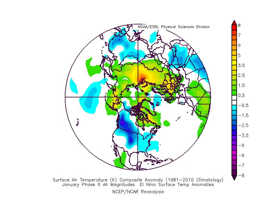 The upcoming week will run milder than normal- lining up perfectly with MJO Phase 4.
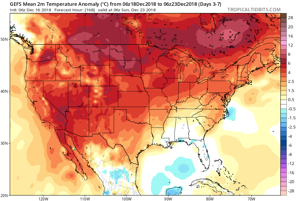 The first of our targeted holiday storm systems will come at the tail end of the warm Phase 4 and will likely deliver a wind-whipped rain in here as early as Wednesday night and Thursday morning. However, as the storm pulls northeast along the Ohio River, it’ll deepen on its journey into the eastern Great Lakes region. This will help pull colder air into the region, likely resulting in rain transitioning to snow Friday. Given the path of the storm, this doesn’t favor some sort of prolonged backlash snow event, but it could be enough to result in accumulating snow across eastern Ohio Valley sections and downwind of the snow belt regions of northern IN, OH, and MI.
 The pattern, as a whole, appears to be one of transition to close the month and open January and it’s not really until we get to mid-January where we think all of the drivers “align” to create more of a lock and hold cold pattern. With that said, a stormy late December pattern can present problems, even in the midst of relatively mild times. We’ll be here to dissect the storms as they come throughout the holiday season…
 The early spring “fling” has lulled many into believing winter’s finished. While the worst of the winter is certainly behind us, we continue to think a dose of “reality” awaits as we progress through the better part of the first half of March. To be more specific, we feel the period March 6th through the 20th will offer up below average temperatures and an active pattern- capable of producing wintry threats.
 Sure enough, modeling is going to the pattern that will produce below normal temperatures (doesn’t appear to be anything particularly frigid, but colder than average, nonetheless) through mid-month.
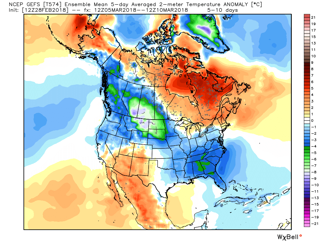
 With blocking in place, an undercutting jet will serve to deliver an active storm track.
 Keeping in mind March winter events need multiple items to come together to create impactful situations, it’s also important not to simply “buy in” to the idea that just because it’s been warm lately that winter is finished. March can be a wild month, as long-time Hoosiers are aware. The pattern we’re heading into over the next 10-14 days is one that’s been void most of the winter (high latitude blocking in place) and can serve as the player needed to flip a “nuisance” variety late-winter event to one that’s much more significant. We’ll need to remain on guard for the potential of one or two “more significant” wintry events as we move through the first couple weeks of the month.
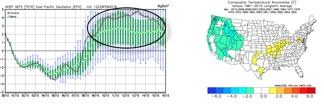 The end result is one that should promote colder than average times over the next couple weeks, overall, along with an active storm track. With blocking in place, the potential of one or two more significant late-winter events are on the table, and we’ll have to fine tune specifics as the individual storms come. While confidence is high that someone within the Ohio Valley region is likely to still deal with a big-hitter event, there’s no way to get specific until the individual players are on the field. Thereafter, the pattern should begin to transition to one more conducive for “stick and hold” spring conditions during the latter portion of the month.
 II. We’re hopeful for much needed sunshine Sunday as we’ll be in between storm systems, however any sun that we see won’t last long.
 While this is an unseasonably warm pattern (we forecast highs of 50°, or above, 5 out of 7 of the upcoming days, and at least 2 60°+ days), it’s one that will likely result in periods of heavy rain not only next week, but in waves over the upcoming 10 days.
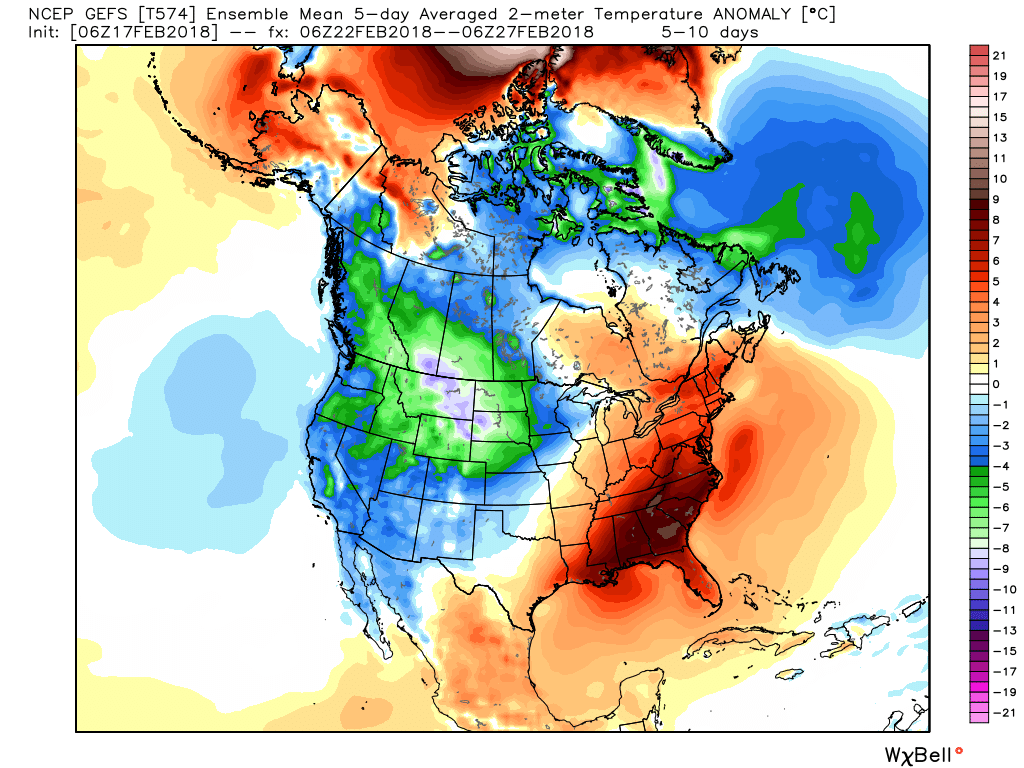
 Widespread 10-day rainfall numbers of 3″ to 4″ will be likely in this setup, including locally heavier amounts of 5″ to 6″ in spots. Certainly, if you live near waterways we suggest having a plan in place as it’s not a matter of if, but when flooding takes place in spots across the region with such a setup.