I. Unseasonably cool weather dominates the area to open the period with a late warming trend.
II. Widespread dry conditions persist through the upcoming week.
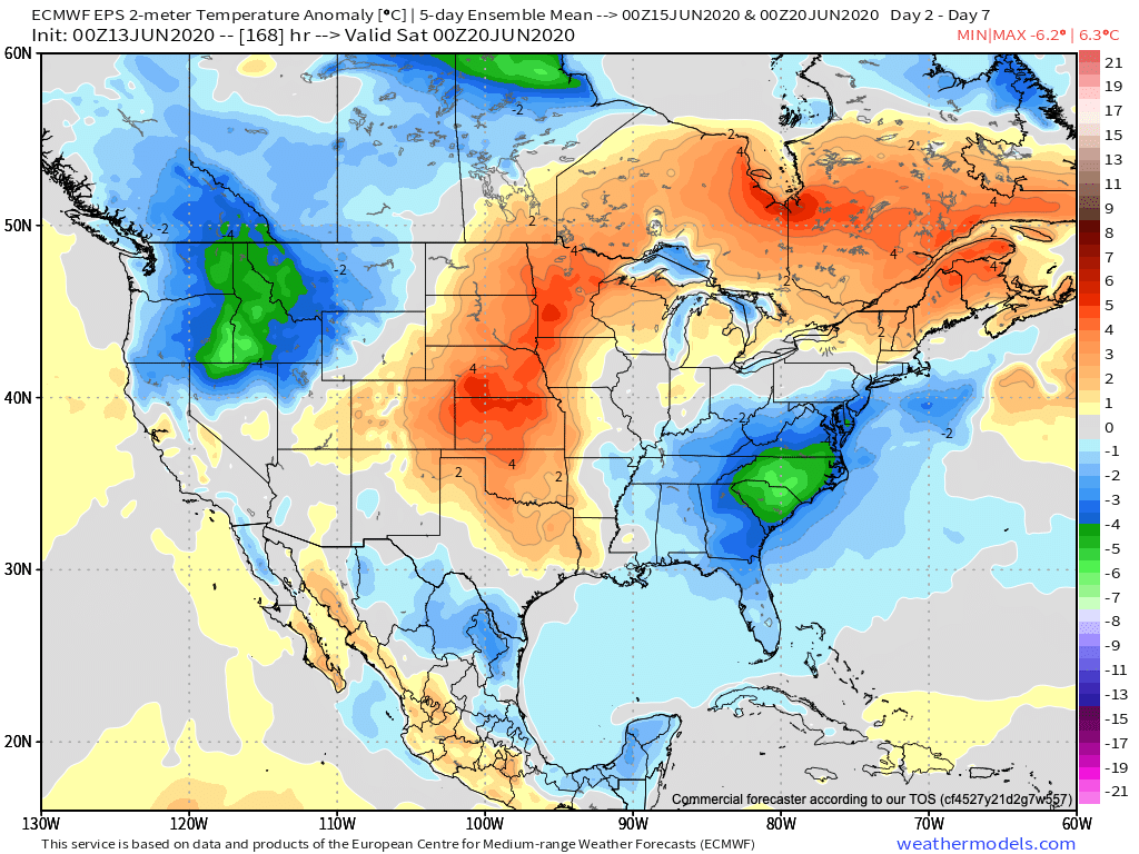
Between the cool pattern to open the period and warmth to end, temperatures will balance out very close to “average” for the period as a whole.
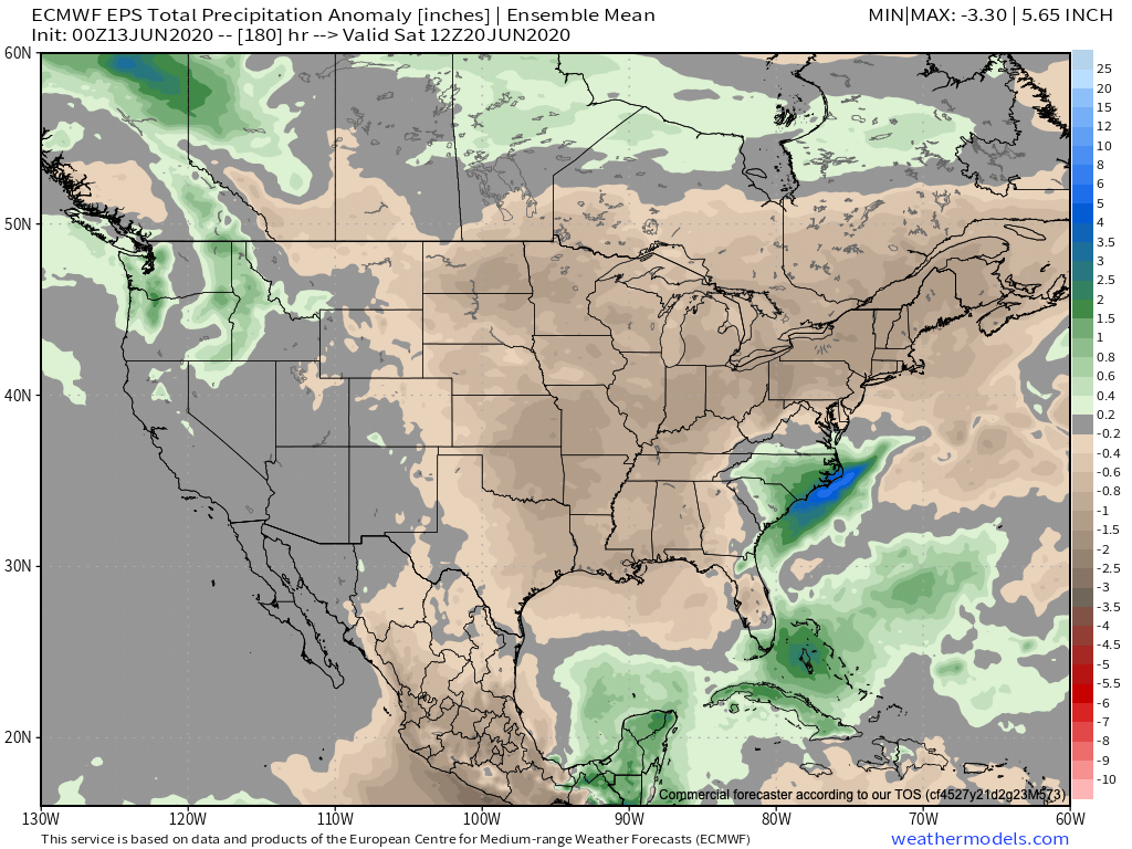
The forecast period will run much drier than normal from the Plains and points east. The one exception? Along the Carolina coast, thanks to a stalled cold front.
We’re only forecasting 0.10″ to 0.25″ over the upcoming 7-day period across central Indiana.
Forecast Period: 06.13.20 through 06.20.20
A very quiet weather pattern is ahead through the forecast period. A weak disturbance will move southeast this morning across the region. While northern parts of the state picked up measurable rainfall this morning, most of this will scoot east of immediate central Indiana. This system will also serve to reinforce the cool pattern in place into early parts of next week. In fact, overnight lows tonight will fall into the 40s as far south as central Indiana. Anyone else craving fall?! The pattern beyond will feature a warming trend along with continued dry weather. Heat and humidity will build in earnest late in the period along with an opportunity for scattered showers and thunderstorms next weekend ahead of an approaching cold front. Between now and then, enjoy the quiet conditions.
The balance of the upcoming 7-10 days will feature bone dry conditions across central Indiana. A fast moving disturbance will drop southeast Saturday and could spawn a scattered shower across central Indiana, but we believe the more concentrated rain activity will remain to our east and southwest. If you do see a Saturday shower, count yourself lucky! This disturbance and associated cold front will serve to reinforce the dry airmass currently in place, along with bring temperatures down another couple of “notches” for the weekend (wouldn’t be surprised if some outlying areas get into the 40s Sunday or Monday mornings).
As we look ahead, a ridge of high pressure will dominate next week’s weather pattern. An extended stretch of dry (pleasant humidity levels), sunny days can be expected with a slow warming trend.
A ridge of high pressure will dominate our weather pattern next week as a “cut off” low tracks into the Southeast and Carolinas. The end result will be an extended period of dry weather for our region.
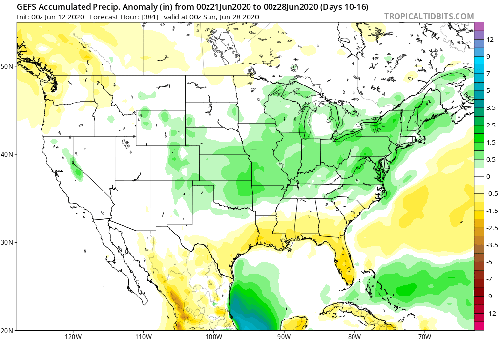
Things begin to get a little more “murky” late next week as forecast model solutions differ significantly. The new GFS forecast model drives a cold front into the Ohio Valley before stalling out as multiple disturbances ride along the boundary. This would lead to needed rain (and potentially heavy rain at that) late next week into next weekend. Meanwhile, the European model isn’t nearly as excited about this wet weather potential. The reality likely lies somewhere in between and we’ll trend our forecast wetter late week, but hold on the heavy rain threat for now. Stay tuned.
With that said, we do believe (given the pattern drivers discussed below) that the wetter trends shown on the GFS ensemble data in the Week 2 (and beyond) time frame has validity.
Precipitation anomalies Days 6-12
Precipitation anomalies Days 10-16
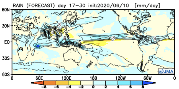
The latest JMA Weekly data also shows a similar wet idea during this time period.
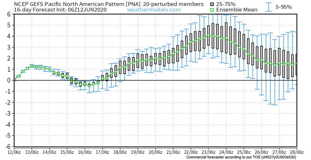
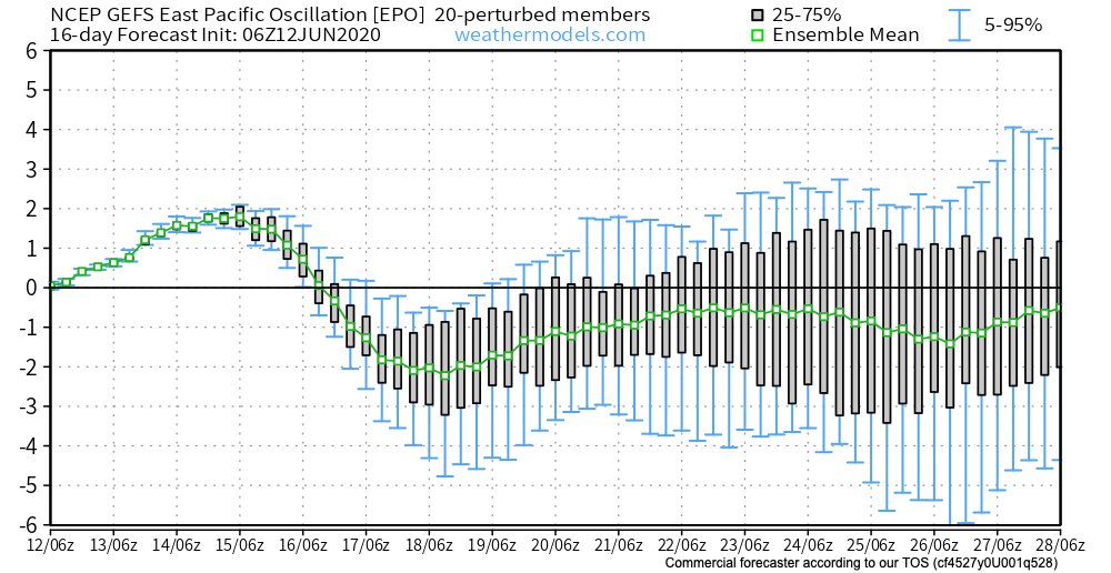
As we look at the PNA and EPO, the transition in both teleconnections next week do give credence to the wetter them shown above during the said period.
Additionally, the positive PNA (image 1 above) and negative EPO (image 2 above) argue for the possibility of another period of cool weather to wrap up the month. This would come after transitional heat late next week.
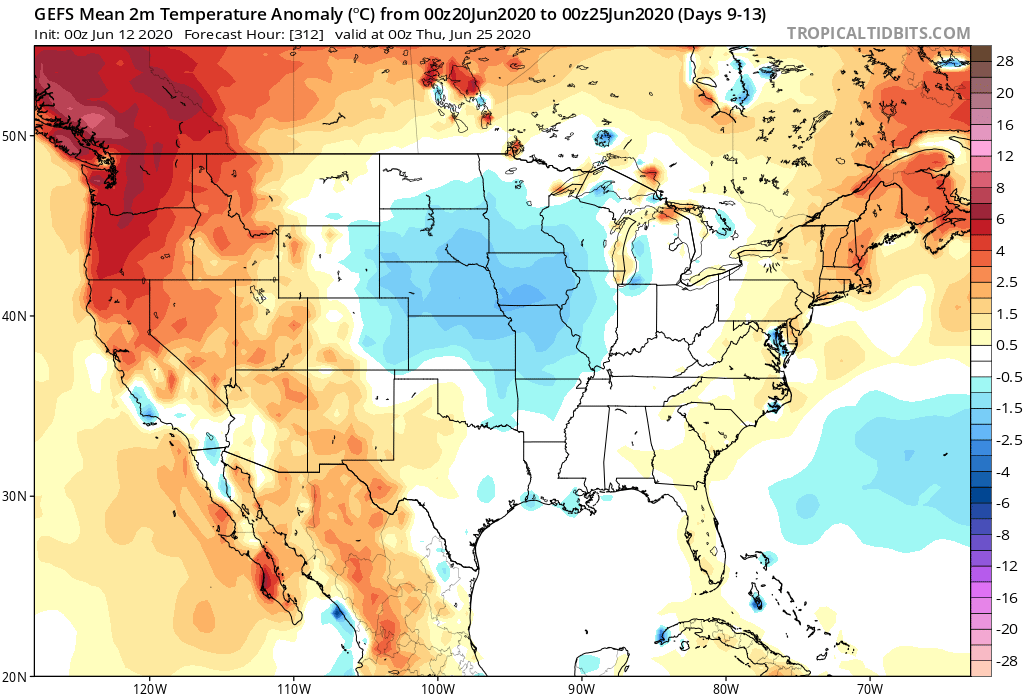
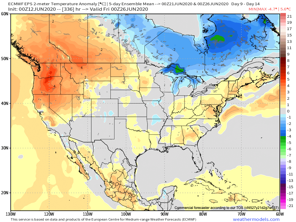
The GEFS is cooler than the European during this time frame. Given the above, it wouldn’t surprise us if the Euro is forced to cool as we get closer to this period.
We’re undoubtedly entering into a critical time frame for the remainder of the summer. The upcoming couple of weeks will go a long way in determining the balance of the rest of this season. Despite the short-term dry pattern, we do believe (at least locally), rain will return before things get out of hand. The same may not be able to be said just to our west. It’s there (more from the Rockies into the Plains) where we think July heat will build in more significant fashion with the drier soils.
II. Strong cold front delivers unseasonably cool close to the week
A warm open to the forecast period will transition much cooler to close the week. All-in-all, things will “balance out” close to average, locally.
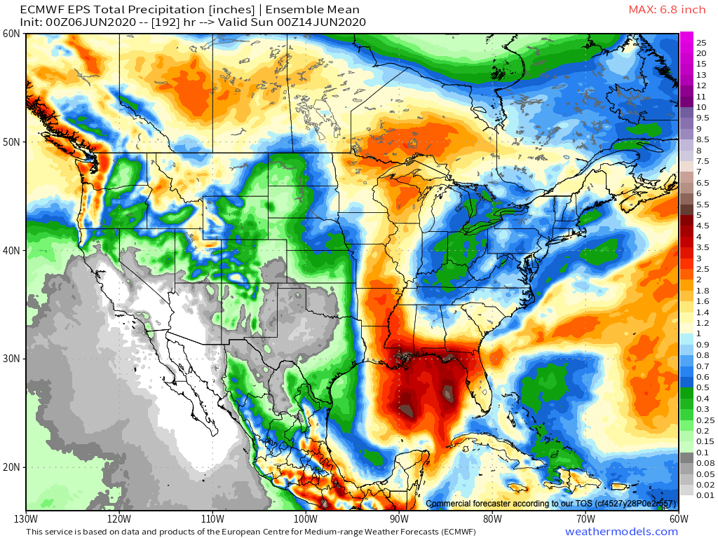
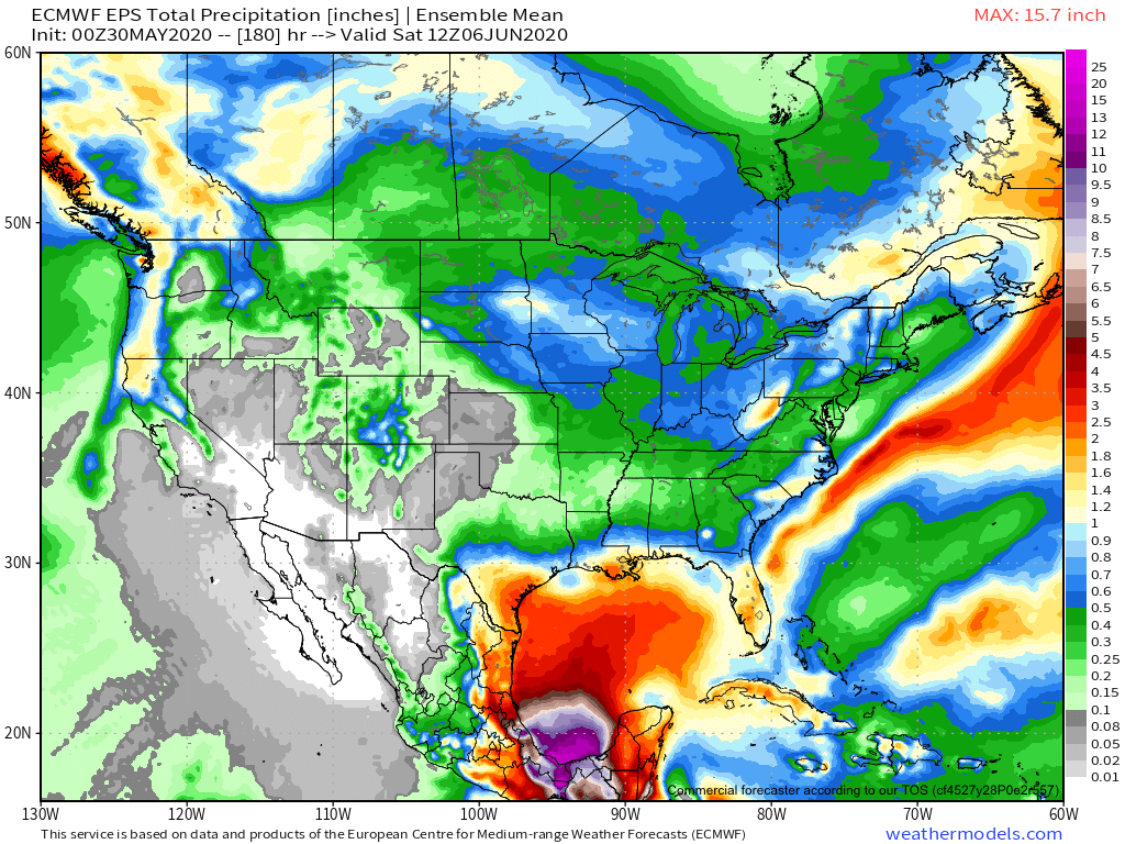
Overall, it’s a dry pattern from the Plains into the East. The one exception? Where Cristobal’s remnants track and Northwest.
The heavy, tropical moisture associated with Cristobal is still expected to remain to our west. Wednesday will likely be our wettest day of the period which should feature 0.25″ to 0.75″ amounts over the upcoming 7-days.
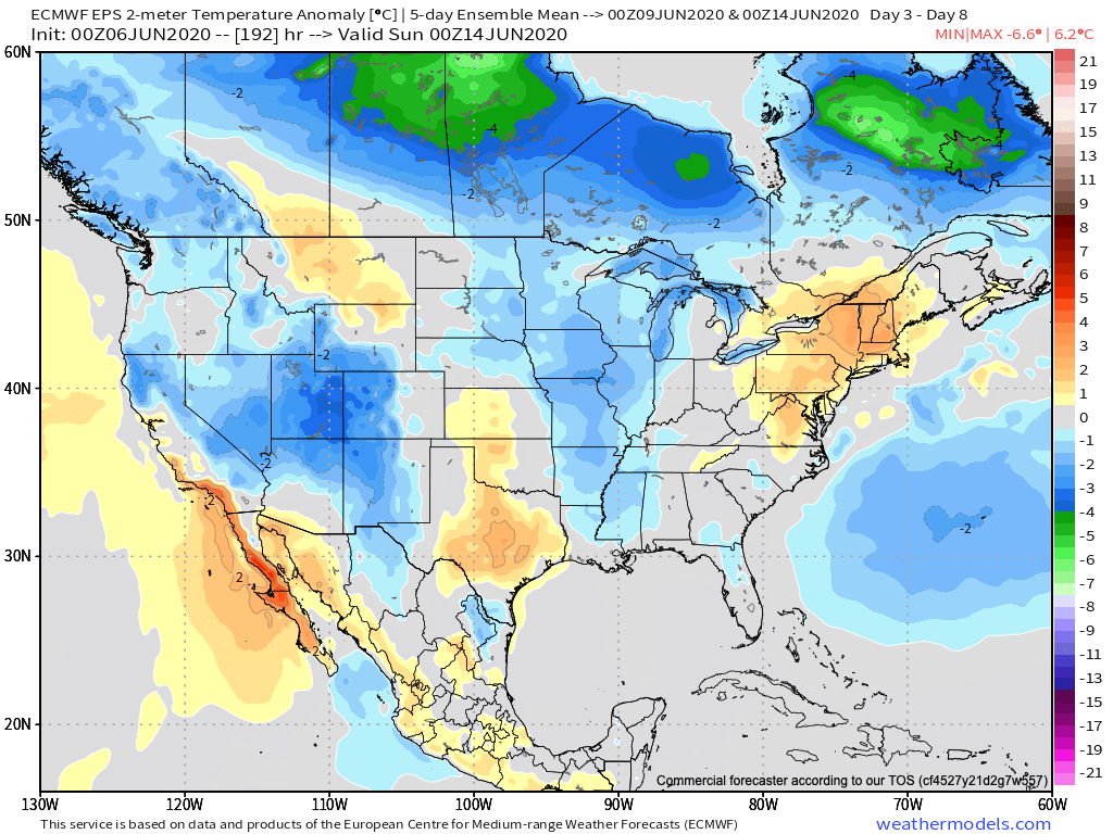
Forecast Period: 06.06.20 through 06.13.20
Though it’ll still be a warm weekend, less humid air will be welcomed with open arms. Dry conditions will prevail through the weekend and as we open up the new work week, including plentiful sunshine. All eyes through the weekend will be on the Gulf of Mexico and Tropical Storm Cristobal. Cristobal will slowly strengthen over the next 24-36 hours before making landfall as a strong tropical storm along the southeast LA coastline. While we still don’t think we’ll be directly impacted by Cristobal’s remnants (those will track through the MS Valley and into the Upper Midwest), the fetch off the Gulf Coast directly ahead of a midweek cold front will lead to better chances of rain late Tuesday into Wednesday. That aforementioned cold front will be the first of two fronts to sweep the region before week’s end. The second front that blows through Friday will usher in a fall-like airmass next weekend.
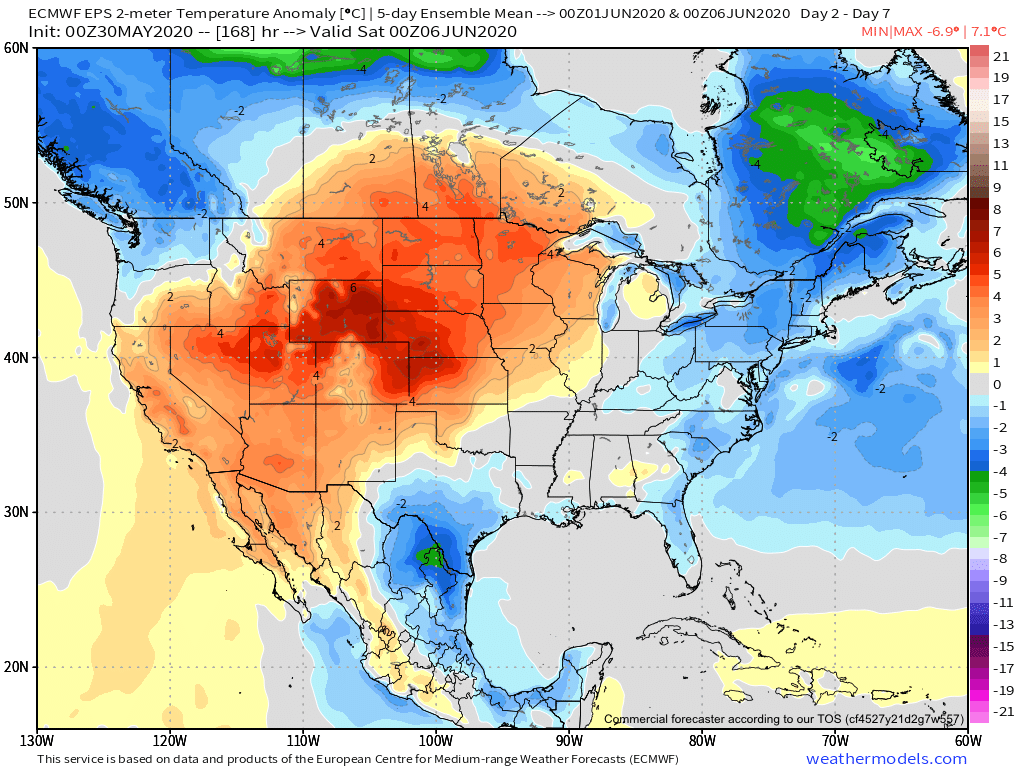
I. May ends and June opens with well below normal temperatures and humidity levels.
II. Summer pattern emerges during the 2nd half of next week, along with a return of hefty storms.
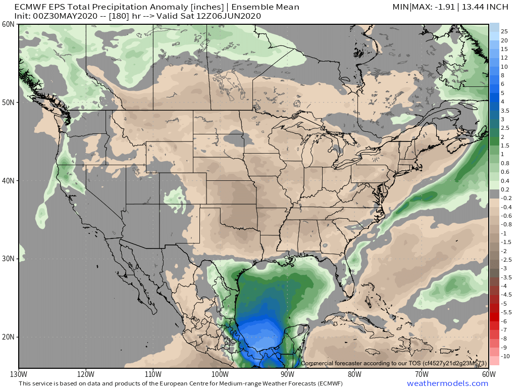
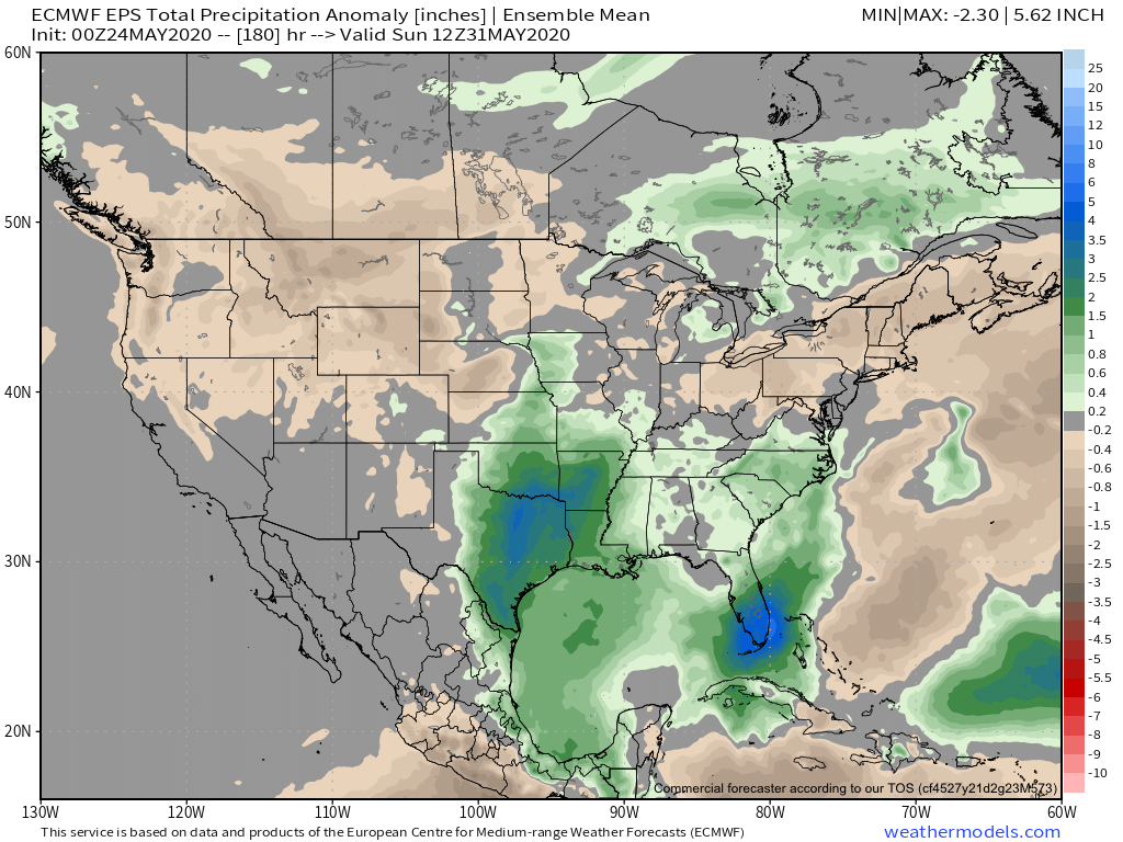
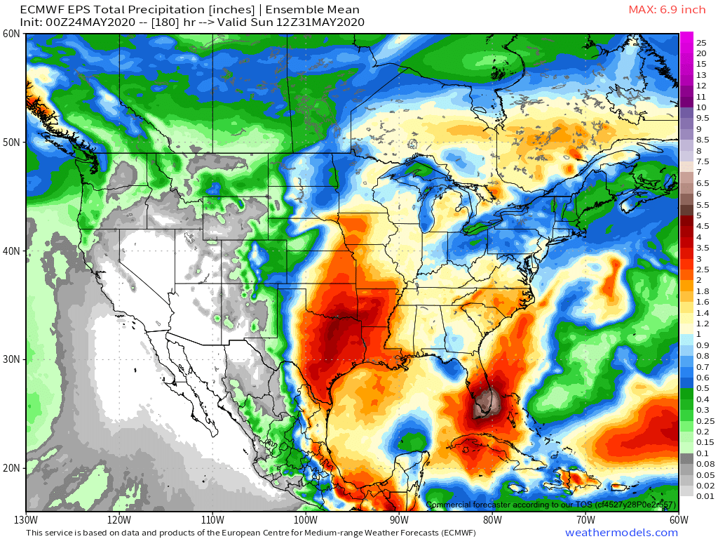
The upcoming 7-day period will be dominated by 2 distinct patterns: cool & refreshing (now through Tue.) and hot/ sticky (Wed. on). Overall, this will lead to a week that “averages out” close to normal.While the pattern looks dry overall (and certainly will be up until the middle of next week), there’s the potential of storm clusters diving in from the northwest and providing heavy rain late in the period.We’re actually more bullish on the precipitation front than what models currently portray. We’re going with a 7-day total between 1”-2” across central Indiana- most of which falls in the Wednesday-Friday time frame. The Storm Prediction Center doesn’t currently outline a threat of severe weather in the upcoming period. However, that may change as we get closer to the back half of the week.
Forecast Period: 05.30.20 through 06.06.20
Cool, Canadian high pressure will dominate our weekend weather, continuing into early parts of next week. Enjoy the refreshing air while we have it as an upper ridge will expand east, providing a return of warm to hot and muggy weather by the 2nd half of the forecast period. This transition will also be met with the opportunity of “ridge riding” thunderstorm clusters into the Ohio Valley by mid to late week. These clusters will potentially deliver severe wind and heavy rain and the overall threat will certainly warrant our attention as we move through the next couple of days.
I. Summer-like pattern arrives for most just in time for the unofficial start to summer.
II. Cold front rumbles in late week with a better chance of organized storms and much cooler air for the weekend.
The upcoming 7-day period will feature above normal temperatures for a change overall. Keep in mind, the period will end cooler but warmth (and humidity) will be the headline for the majority of the week.
Overall, precipitation will run near normal levels for the period, primarily driven by “splash and dash” coverage of storms daily.
We are forecasting between 0.50” and 1” this week on a widespread basis. There will, however, be much higher amounts where slow moving storms track.
Forecast period: 05.24.20 through 05.31.20
The majority of this forecast period will feature a “rinse and repeat” forecast on a daily basis: warm to hot, humid, and daily chances of isolated to widely scattered thunder. The exception will be late week (centered on Friday) as a cold front drops in from the north. This will result in better coverage of thunderstorms along with much cooler air by next weekend (good bet lows fall into the upper 40s by next weekend). Looking ahead to early June looks to continue the “back and forth” theme as we welcome in meteorological summer.