Category: 7-Day Outlook
 Highlights:
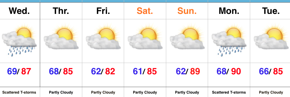
- Scattered strong-severe storm threat Wednesday
- Drier close to the week
- Next front arrives Monday PM
Keeping An Eye On Wednesday’s Storm Threat…Today’s rain numbers weren’t uniform in the least, but several neighborhoods picked up beneficial rains of over 1.5″. Wednesday will also feature the threat of showers and thunderstorms (again, some with locally heavy downpours). Some of these storms could also reach strong to severe levels during the afternoon/ evening, particularly if morning rain doesn’t “get in the way.” We’ll watch data overnight and update accordingly come morning.
We’ll turn drier and slightly cooler to close the work week and head on into the weekend. The heat will begin to crank again early next week, with highs around 90 Sunday and Monday. Our next weather maker looks to arrive Monday evening as a cold front pushes in from the north. We’ll feature shower and thunderstorm chances in our Monday PM forecast.
Upcoming 7-Day Precipitation Forecast:
- Snowfall: 0.00″
- Rainfall: 0.50″-1.00 (locally heavier totals)
Permanent link to this article: https://indywx.com/strong-storm-threat-wednesday/
 Highlights:
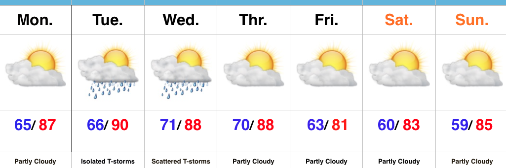
- Less humid open to the week
- Mid week storms
- Drier weekend
Warm, But Less Humid…As Sunday afternoon progressed into evening, notably drier air moved into central IN. That less humid feel will be with us as we open the work week, but will still warm quickly (upper 80s this afternoon).
An increasingly moist air mass will return Tuesday into Wednesday and will promote locally heavy rainfall within thunderstorms that develop. We expect isolated to widely scattered storm coverage Tuesday and scattered coverage Wednesday. While uniform significant rainfall isn’t likely, localized torrential downpours will be possible as precipitable water values (PWATs) increase. Additionally, strong to severe storms will be possible.
A drier air mass will return to close the week and head into the weekend. At one time, models suggested we’d deal with a slow-moving “cut off” low pressure system, but recent trends continue the drier theme.
Upcoming 7-Day Precipitation Forecast:
- Snowfall: 0.00″
- Rainfall: 0.25″-0.75″ (locally heavier amounts)
Permanent link to this article: https://indywx.com/mid-week-storms/
 Highlights:
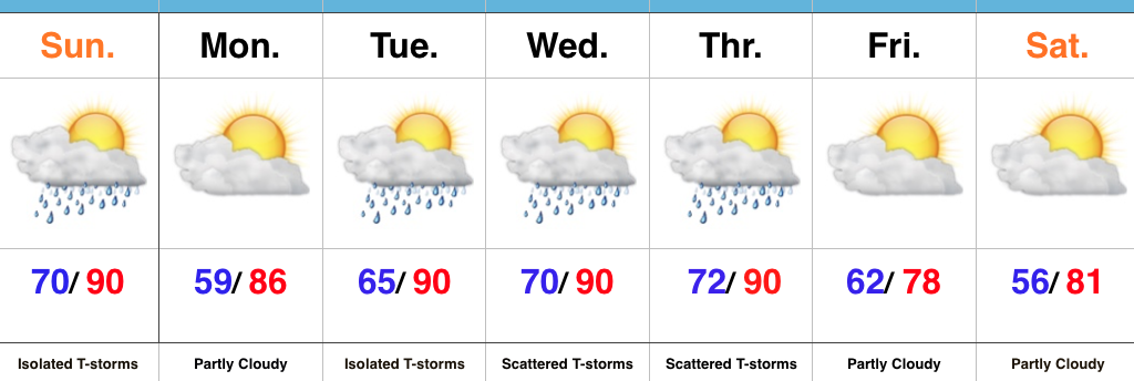
- Storm threat over the southern half of the state
- Turning less humid
- Scattered mid week storms
- Cooler to close the week
Another Hot One…A weak frontal boundary will slip through central IN this afternoon and evening and serve as a “trigger” for isolated to widely scattered thunderstorms for central and southern parts of the state. We’ll also turn less humid this evening into Monday.
Warmth and humidity surge again Tuesday and there will be times of scattered showers and thunderstorms through Thursday. Uniform rains aren’t expected, but there will be some localized heavy downpours. Remember the saying of “haves and have nots.”
A cooler northeasterly air flow will arrive to “freshen things up” a bit as we close the week.
Upcoming 7-Day Precipitation Forecast:
- Snowfall: 0.00″
- Rainfall: 0.25″-0.75″
Permanent link to this article: https://indywx.com/turning-less-humid/
 Highlights:
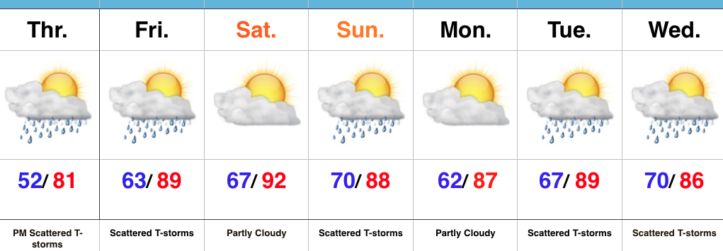
- Storm chances for some by this afternoon/ evening
- Turning hot and humid
- Better chances of widespread rain by the middle of next week
Plan To Sweat…The period opens with a challenging northwest flow aloft. Already this morning we note a complex of showers and thunderstorms across MN and IA. This storm complex will continue to drop to the southeast and will likely impact portions of the state later this afternoon and evening- especially north and northeast areas. An additional storm complex is possible Friday.
The big story to close the week and head into the weekend will be the push of hot, humid air. Many will be close to 90 degrees tomorrow and widespread lower 90s are a lock Saturday. Plan for frequent breaks if your plans take you outside for any length of time.
As we look deeper into next week we note an increasingly wet and stormy signal on the models and will trend our forecast in that direction for the middle and latter portions of the week.
Upcoming 7-Day Precipitation Forecast:
- Snowfall: 0.00″
- Rainfall: 0.50″-1.00″
Permanent link to this article: https://indywx.com/turning-hot-challenging-nw-flow-pattern-aloft/
 Highlights:
- Dry and refreshing
- Heat and humidity build
- Timing rain and storm chances
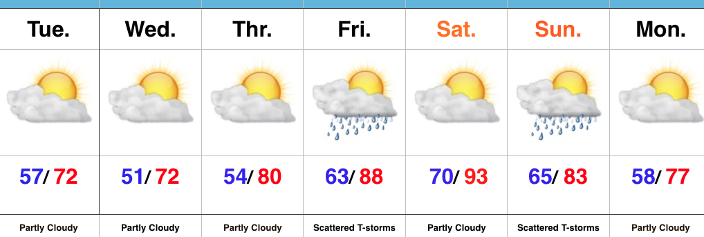
Open The Windows…A northwest flow is ushering in a refreshing feel across the region today. Find a way to eat lunch outdoors and open up the windows to let the fresh air in! Dry conditions will prevail into mid week. The coolest night will come tonight/ Wednesday morning with lows in the lower 50s (wouldn’t be surprised by upper 40s away from the city in spots). Gradually moderating temperatures will come for the latter portions of the week, and showers and thunderstorms could pop as humidity surges Friday.
The weekend looks downright hot- especially Saturday. Timing of southwest-moving thunderstorm complexes will be an issue over the weekend, but for now we think Saturday is dry and want to mention the threat of storms Sunday. Stay tuned as we fine tune things.
Upcoming 7-Day Precipitation Forecast:
- Snowfall: 0.00″
- Rainfall: 0.50″-0.75″
Permanent link to this article: https://indywx.com/refreshing-feel/
