Category: 7-Day Outlook
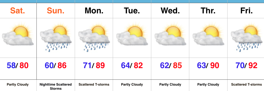 Highlights:
- Dry and pleasant weekend
- Storms return late Sunday night into Monday
- Heat builds late next week
Refreshing Feel…A weak disturbance is tracking through central IN this morning with a band of clouds and a couple sprinkles. That said, sunshine will quickly return late morning into the afternoon and set up a beautiful day, along with pleasant temperatures and low humidity.
Our next round of storms will arrive from the NW late Sunday night into Monday. A few of these storms could be strong to severe and also include locally heavy rain.
Modeling disagrees on the magnitude of cooling and drier weather behind Monday’s front. The more aggressive GFS would imply another push of pleasant air for a couple days Tuesday-Wednesday, while the European isn’t as bullish. For now, we’ll split the difference and revisit tomorrow.
One thing that modeling does agree on is building late week heat. Expect a hot, humid close to the work week.
Upcoming 7-Day Precipitation Forecast:
- Snowfall: 0.00″
- Rainfall: 0.75″-1.25″
Permanent link to this article: https://indywx.com/pleasant-weekend-before-storms-return/
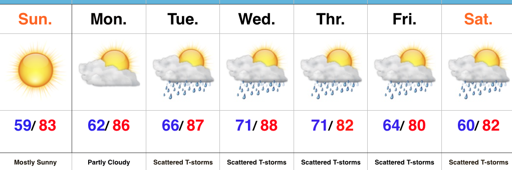 Highlights:
- Dry weather continues
- Wet, active pattern returns mid week
Beautiful Sunday…High pressure will remain in control of our weather as we wrap up the weekend. As a result, we can expect lots of sunshine and comfortable temperatures, including low humidity levels. All-in-all, we really can’t ask for better weather this time of year.
Monday will remain dry, but the deeper we progress into the week, rain and storm chances will go up. While we include the mention of rain and storms in the forecast each day from Tuesday on, please know that it won’t rain the entire time and there will be many dry hours each day. That said, it does appear as if we’re entering another active stretch, and fine tuning will be required to pinpoint specifics around timing and track of storm complexes in the days ahead.
Upcoming 7-Day Precipitation Forecast:
- Snowfall: 0.00″
- Rainfall: 0.75″-1.50″
Permanent link to this article: https://indywx.com/wrapping-up-the-weekend-on-a-nice-note/
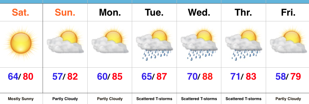 Highlights:
- Dry and pleasant weekend
- Moisture and storms return next week
- Another push of cool air next weekend?
Sunglasses Required…What a great feel we’re greeted with out there this morning! Low humidity and pleasant temperatures will be with us through the weekend, along with lots of sunshine. Sunday morning will feature many neighborhoods in the middle to upper 50s across central IN. Mid-July, what?! 
Moisture will slowly return as we back our air flow around to the SW early next week. Additionally, we’re tracking multiple disturbances mid week that will promote increased chances of thunderstorms.
An early look at late week shows potentially another push of dry and cool air to set-up a beautiful close to the work week. We’re getting spoiled.
Upcoming 7-Day Precipitation Forecast:
- Snowfall: 0.00″
- Rainfall: 0.75″-1.50″ (locally heavier totals)
Permanent link to this article: https://indywx.com/great-weekend-weather/
-
Filed under 7-Day Outlook, Forecast Discussion, Forecast Models, Rain, Severe Weather, Summer, T-storms, Unseasonably Cool Weather, Unseasonably Warm, Weather Rambles
-
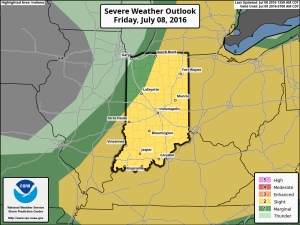
July 8, 2016
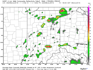
1.) We’ve got another warm, humid day dialed up and as a cold front moves in this afternoon, scattered strong to severe storms are possible. We think east-central Indiana stands the greatest threat at experiencing a severe storm later this evening.
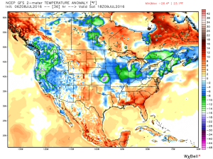
 2.) The aforementioned cold front will sweep through the state tonight and allow a much drier and cooler air mass to push in for the weekend. We’ll enjoy a downright pleasant feel this weekend, including lots of sunshine. Enjoy!
 3.) Dry weather should continue into early next week, but wet and stormy weather will return as early as Tuesday, continuing into the latter portions of the week.
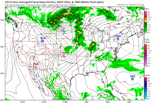 This is the start of what should be a rather wet period for mid and late month.
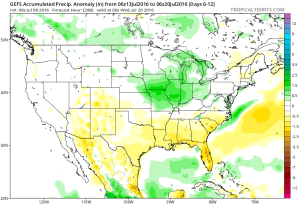 4.) This is also a continued “transient” pattern through the end of the month, meaning we really don’t see any sort of sustained dry, hot weather in the foreseeable future…
Permanent link to this article: https://indywx.com/friday-morning-rambles-3/
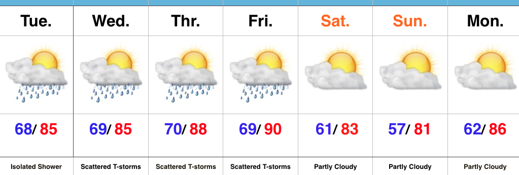 Highlights:
- Muggy times return
- Multiple storm chances mid/ late week
- Strong-severe storm potential
- Drier weekend
Air You Can Wear…A quick step out of the door this morning will quickly remind you that we’re in the heart of summer. A tropical feel will remain through the middle and latter portions of the work week. While an isolated shower is possible this afternoon, we should remain mostly dry across the state.
Better chances of showers and thunderstorms will return Wednesday, and we target the chances of two round of storms- morning and night. Some of these storms could be strong to severe, including damaging straight line winds. Don’t be surprised if updated Storm Prediction Center outlooks place a Slight Risk into portions of the state Wednesday.
Additional storm chances will be present Thursday and Friday before a drier air mass arrives in time for the weekend. With the drier air will also come cooler nights- lower 60s Saturday morning and upper 50s Sunday morning. After the warm, humid time of things the next few days, the drier air mass will feel quite refreshing.
Upcoming 7-Day Precipitation Forecast:
- Snowfall: 0.00″
- Rainfall: 1″ – 2″
Permanent link to this article: https://indywx.com/periods-of-storms-before-a-pleasant-weekend/
