Category: 7-Day Outlook
 Highlights:
- Storm coverage increases
- Cooler than days past
- Unsettled pattern next week
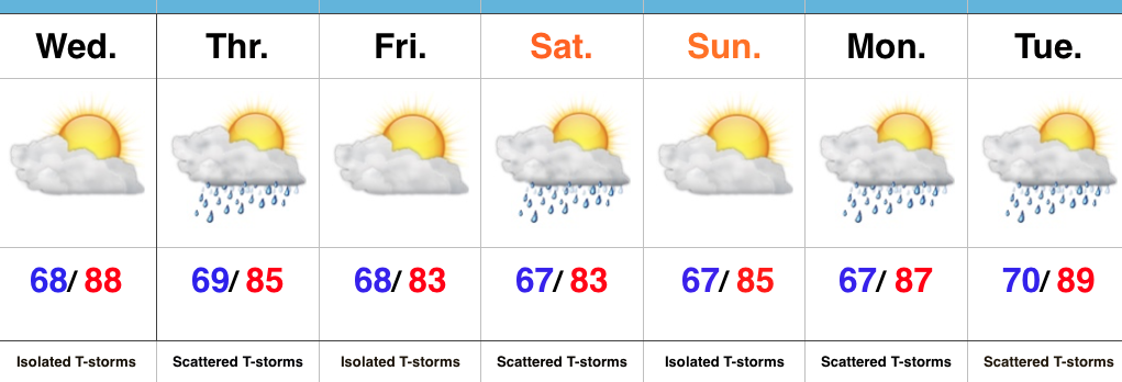
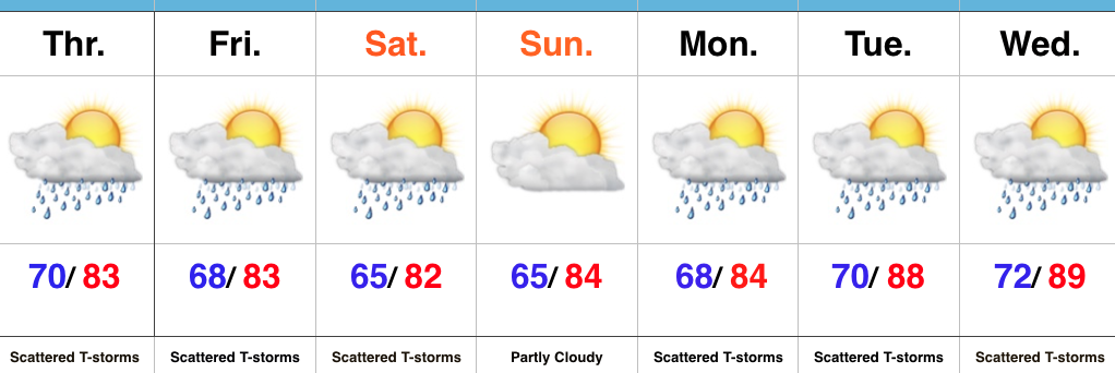
Stormy At Times…Widespread thunderstorms have resulted in as much as 4″-5″ of rain across southeastern IN during the early morning hours. Flash flooding has resulted (including in and around the Cincy area, as well). Closer to the home front, upper air energy will combine with a weak surface wave of low pressure to result in an enhanced storm chance this afternoon and evening across central IN. Some locally heavy rain will accompany the stronger storms that develop, along with vivid lightning.
Scattered storm chances will remain Friday into Saturday, but there will also be plenty of dry hours, as well. Drier air should keep most of the state rain-free Sunday before an unsettled regime returns for early and middle parts of next week.
Upcoming 7-Day Precipitation Forecast:
- Snowfall: 0.00″
- Rainfall: 0.75″-1.25″ (locally heavier totals)
Permanent link to this article: https://indywx.com/storms-increase-in-coverage-this-afternoon/
 Highlights:
- Storm chances, but timing needs fine tuning
- Turning slightly cooler over the weekend
- Unsettled regime continues early next week
More Sunshine Today…Areas of heavy rain resulted in localized flooding across south-central IN yesterday. While we can’t go with a completely dry forecast today, it will be an overall drier day when compared to Tuesday. An isolated thunderstorm is possible, but most should remain dry.
Upper level energy and increased moisture will lead to a more widespread coverage of showers and thunderstorms Thursday. With precipitable water values approaching 2″ in spots Thursday, localized hefty downpours will again be possible.
We’ll continue scattered storm chances this weekend, particularly Saturday, as renewed upper level energy moves overhead. After a slightly cooler stretch of weather, compared to normal, we’ll begin to heat things back up next week.
Upcoming 7-Day Precipitation Forecast:
- Snowfall: 0.00″
- Rainfall: 0.50″-1.00″ (localized heavier totals)
Permanent link to this article: https://indywx.com/storm-chances-but-plenty-of-dry-time/
 Highlights:
- Storm chances increase tonight-Monday morning
- Drier, cooler air on deck
- Widespread storms Thursday
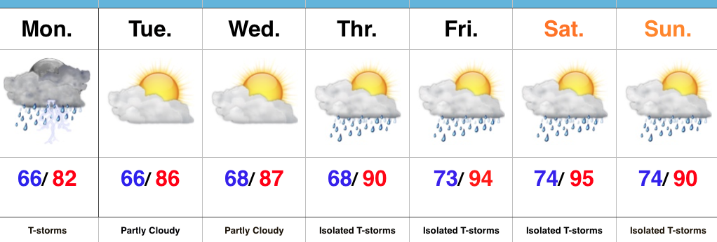
Hang In There…It’s been a long couple of days with high heat and humidity, but relief is in sight. A cold front will move through the state Monday. Ahead of this front, a band of showers and thunderstorms will slide through Indiana. A few of these storms could be strong with locally heavy rain. Best chances of storms across central IN appear to arrive tonight and Monday morning, before transitioning to southern IN Monday afternoon. Drier air will arrive Tuesday into Wednesday.
Our next rain and storm chances are dialed up for Thursday and early indications suggest this could be a fairly widespread event. Though we’ll maintain rain chances next weekend, coverage will diminish when compared to Thursday. Temperatures will be much more tolerable than what we’re dealing with today.
Upcoming 7-Day Precipitation Forecast:
- Snowfall: 0.00″
- Rainfall: 0.75″-1.25″ (Locally heavier totals)
Permanent link to this article: https://indywx.com/unsettled-but-a-better-feel-coming/
 Highlights:
- Much more dry time than stormy
- Heat and humidity reach dangerous levels this weekend
- Cooler next week
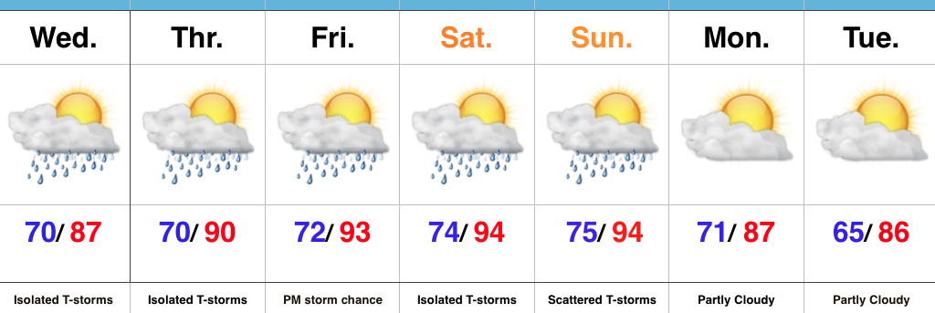
Splash And Dash Storms, But Most Remain Dry…A quick glance at the forecast above may suggest wet times, but don’t let that fool you. “Isolated” and “scattered” are key words. While we’re still keeping an eye on the potential of a more widespread complex of storms late tonight/ early Thursday, we’re far from confident on the precise location of this potential storm complex and short term modeling isn’t offering up much help. Regardless, with such a muggy air mass in place, an isolated storm could fire anytime between now and the weekend. There are a couple periods we’re watching for more concentrated storm potential (Friday evening and Sunday). Timing remains fluid.
The big story with this forecast remains the heat and humidity. Temperatures will soar into the middle 90s this weekend and when you combine those hot readings with dew points in the lower and middle 70s, dangerous conditions result for anyone with longstanding outdoor plans. Have a means of taking frequent breaks and receiving plenty of water. The heat and humidity this weekend will be a serious situation.
Upcoming 7-Day Precipitation Forecast:
- Snowfall: 0.00″
- Rainfall: 0.25″-0.50″ (locally heavier totals)
Permanent link to this article: https://indywx.com/cranking-up-the-heat/
 Highlights:
- Storms to start the work week
- Heat and humidity build
- Heat doesn’t last
Renewed Storm Chances Later Today…Alarm clocks weren’t needed today as a big complex of storms and heavy rain rumbled through the state during the pre-dawn hours. Many neighborhoods received a quick 2.5″+ during the overnight and predawn hours. As we write this, renewed thunderstorms are firing to our west and will impact portions of the state later this afternoon. Additional hefty rains are a good bet for some.
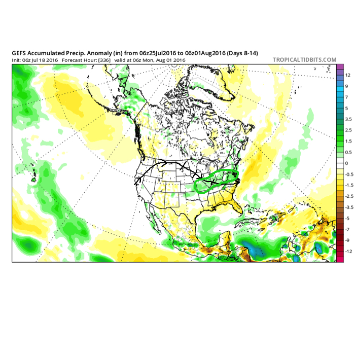
We’ll dry things out as we rumble through the mid week stretch and while isolated storms are possible to close the week, most folks should remain dry as a big ole’ upper ridge builds over the mid west. The big story will be intensifying hot, humid weather- centered on Friday-Saturday. Heat indices will approach 100-105 degrees during this time frame, as well. The good news is that forecast data points to the associated hot dome backing west and setting up shop over the Rockies to close the month and open August. Accordingly, the hottest anomalies will shift west, as well. We’ll be left with a NW flow aloft providing a cooler and unsettled stretch to close the month of July and open August.

The pattern to close July and open August should look rather familiar to what we’ve seen the majority of summer. NW flow aloft with frequent rain/ storm chances. Courtesy: TropicalTidbits
Upcoming 7-Day Precipitation Forecast:
- Snowfall: 0.00″
- Rainfall: 0.50″-1.00″
Permanent link to this article: https://indywx.com/stormy-start-heat-builds-late-week/
 Highlights:
