Category: 7-Day Outlook
 Highlights:
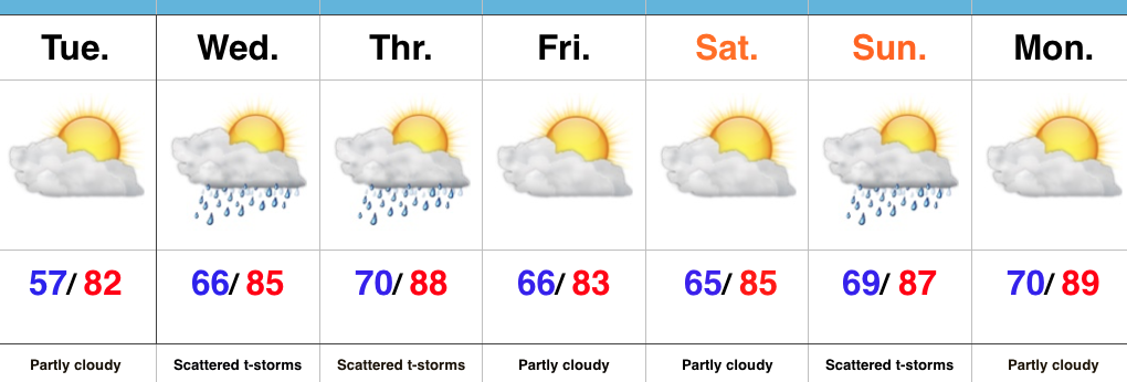
- Dry pattern continues today
- Mid week storms
- Questions abound this weekend
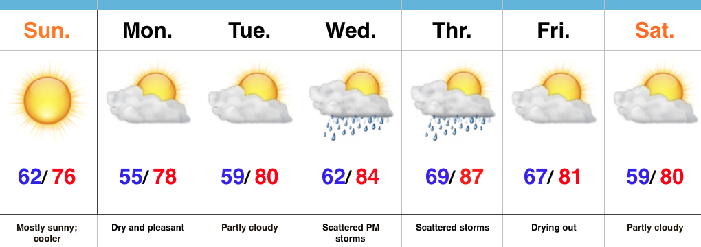
Heat And Humidity Return…High pressure will give way to an approaching cold front as we progress from early to mid week. Ahead of the front, a southwest air flow will transport an increasingly warm and muggy air mass northward. It’ll, unfortunately, feel much more humid Wednesday and Thursday. With the frontal boundary nearby and the increased humidity, expect scattered to numerous thunderstorms Wednesday and Thursday (along with locally heavy downpours). A couple strong storms are also possible.
We still think drier air will press into central IN to wrap up the work week and head into the first half of the weekend. That said, moisture returns as early as Sunday and leads to a mention of thunderstorms, especially during the PM. Stay tuned as we continue to fine tune timing.
Upcoming 7-Day Precipitation Forecast:
- Snowfall: 0.00″
- Rainfall: 1.00″-1.50″
Permanent link to this article: https://indywx.com/its-still-summer-after-all/
 Highlights:
- Cooler and mostly sunny
- Dry weather into the early parts of the work week
- Midweek storms
Early Fall Preview…A cold front swept through the state last night and was accompanied by strong storms and heavy rain. The unsettled conditions are now to our east and in return we’re left with a much cooler, drier, and breezy day. With low humidity, temperatures running significantly below normal, and a NW breeze in place, you have our approval to begin shifting thoughts to fall. 
Dry and pleasant air will remain in place through early week before we back the air flow around to the SW. Increasingly muggy conditions will return Wednesday into Thursday and as a cold front interacts with the moist air in place, showers and thunderstorms will be on the increase Wednesday into Thursday. The good news? The front should slide to our south and result in dry and pleasant conditions next weekend.
Upcoming 7-Day Precipitation Forecast:
- Snowfall: 0.00″
- Rainfall: 0.50″-0.75″
Permanent link to this article: https://indywx.com/an-early-taste-of-fall/
 Highlights:
- AM fog burns off today
- Scattered storms
- Much cooler air coming
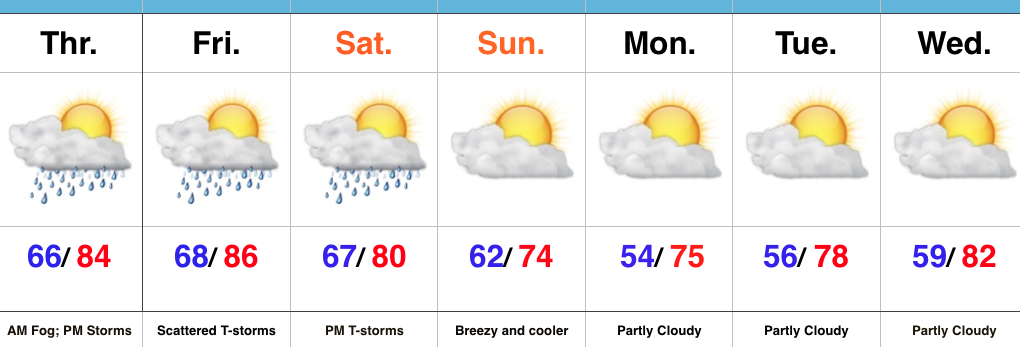
Afternoon And Evening Thunder…Morning fog (some dense) will eventually burn off and give way to a muggy day. As afternoon heating takes place, scattered evening thunderstorms are a good bet, especially north of Indianapolis. We’ll repeat this to wrap up the work week Friday.
A cold front will take aim at the region Saturday evening and scattered showers and thunderstorms will accompany this boundary as it moves through. A few storms could reach strong to severe levels Saturday PM as the front moves through.
Winds will shift to the NW and usher in a much cooler and drier brand of air for the second half of the weekend, continuing into the early portion of next week. Many will likely be craving fall by early next week coming off multiple mornings with lows in the 50s.
Upcoming 7-Day Precipitation Forecast:
- Snowfall: 0.00″
- Rainfall: 0.50″-1.00″
Permanent link to this article: https://indywx.com/scattered-storms-turning-much-cooler/
 Highlights:
- Scattered Showers
- Saturday storm chance
- Early fall feel on deck
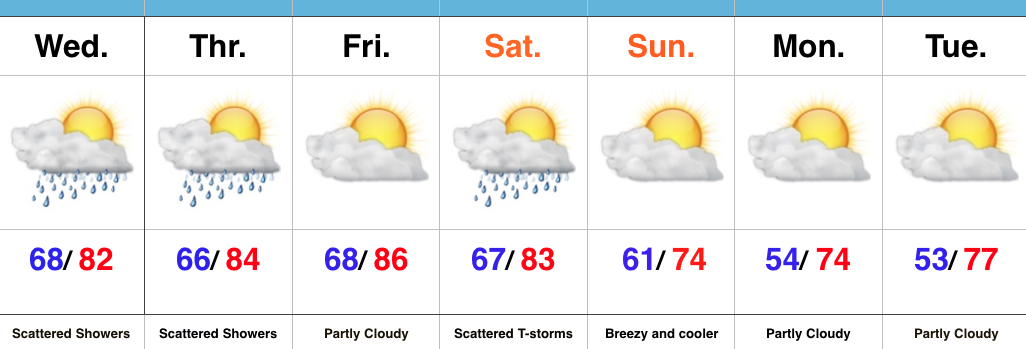
Drier Overall…It’s been a wet few days across the region. While we’ll begin to transition towards a drier regime to wrap up the work week, scattered showers and storms will remain in the forecast today and Thursday. Best concentration of storms will be located across north-central IN this evening. Rain/ storm coverage will be even less on Thursday.
Our next item of interest will arrive on the scene in the form of a cold front Saturday. Showers and a couple gusty thunderstorms are a good bet Saturday afternoon/ evening as the cold front sweeps through the state. Our winds will then shift to the northwest and help usher in a much cooler, drier time of things for the second half of the weekend. Stepping outside Sunday morning will provide a definite hint of fall, complete with a breezy NW wind.
Early next week will continue to feature dry and unseasonably cool times before we turn our attention to what could potentially be a heavy rain maker setting up just past the 7-day period…
Upcoming 7-Day Precipitation Forecast:
- Snowfall: 0.00″
- Rainfall: 0.50″-0.75″
Permanent link to this article: https://indywx.com/early-fall-feel-coming/
 Highlights:
- Periods of rain
- Increasing sunshine as we push into late week
- Weekend cold front
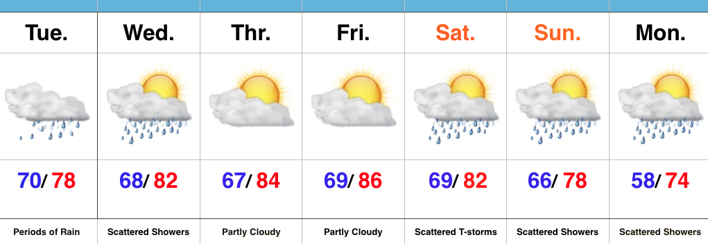
Keep The Rain Gear Handy…Whew, after an incredibly busy evening, things will be much quieter today. Despite not having a severe threat, we will have to deal with wet times as periods of rain continue. Rain coverage will diminish Wednesday, but we’ll keep scattered showers in the forecast.
Drier air will arrive Thursday and Friday, including a partly cloudy sky. The next weather item on the horizon is a weekend cold front. This frontal boundary will help increase storm chances Saturday into early Sunday (a few storms Saturday evening could be on the strong side). MUCH cooler, early fall-like, air awaits next week…
Upcoming 7-Day Precipitation Forecast:
- Snowfall: 0.00″
- Rainfall: 0.75″-1.25″
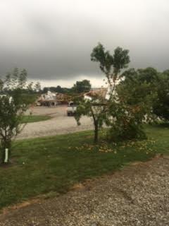
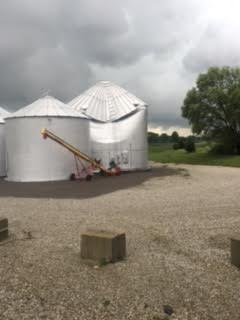
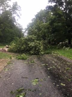
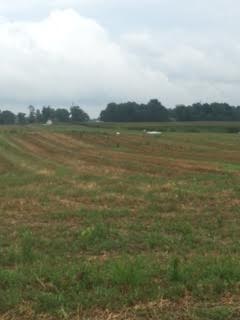
Here are a few photos I shot Monday evening (8.15.16), between 6:47p-6:55p, just after the tornado touched down in Whitestown.


Permanent link to this article: https://indywx.com/another-wet-day/
 Highlights:
