Feeling Tropical Now, But Cooler Air Coming…

Mon.

Tue.

Wed.

Thr.

Fri.

Sat.

Sun.

 Status-weather-storm-night-icon

 Status-weather-showers-day-icon

 Status-weather-clouds-icon

 Status-weather-clouds-icon

 Status-weather-clouds-icon

 Status-weather-clouds-icon

 Status-weather-showers-day-icon

68/ 80

60/ 74

54/ 76

55/ 79

58/ 80

58/ 82

64/ 85 

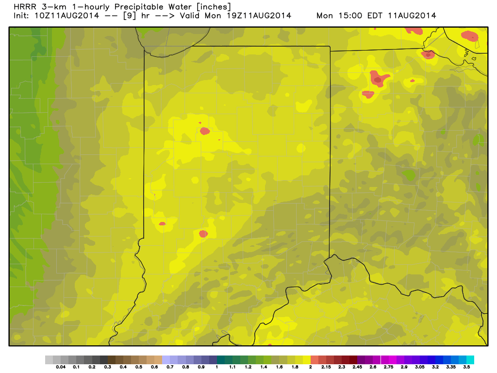
Air You Can Wear…We’re awaking to lots of fog and very muggy conditions.  Dew points remain in the upper 60s and lower 70s (very oppressive)!  A shower or thunderstorm will be possible really at any time today, but most likely this afternoon as the first of two cold fronts drops into the region.  Similar to yesterday, locally heavy downpours will certainly be possible with all of the moisture in the air.

A secondary cold front will blow through Tuesday with a continued chance of scattered showers and thunderstorms.  We’ll get in on a much cooler and drier air flow Tuesday evening and this will set the stage for a very pleasant rest of the work week, including below normal temperatures into the weekend.

Warming Up; Chance Of Storms…Temperatures will moderate and we’ll introduce showers and thunderstorms into your forecast Sunday.  Early thinking on next week suggests a potentially unsettled (stormy) one, but warmer than average.

7-Day Precipitation Outlook:

  • 7-Day Rainfall Forecast: 0.50″-1.00″
  • 7-Day Snowfall Forecast: 0.00″
Precipitable water values will once again approach 2" today and assist in locally torrential downpours around the region.
Precipitable water values will once again approach 2″ today and assist in locally torrential downpours around the region.

Unsettled Couple Days Ahead Before A Taste Of Fall By Mid Week…

Scattered to numerous showers and thunderstorms continue to impact central Indiana, along with localized flash flooding (precipitable water values are currently above 2″ in spots and suggest localized very heavy…

You must be logged in to view this content. Click Here to become a member of IndyWX.com for full access.  Already a member of IndyWx.com All-Access?  Log-in here.

Lots Of Clouds Around, But Not Much Rain…

Sat.

Sun.

Mon.

Tue.

Wed.

Thr.

Fri.

 Status-weather-showers-day-icon

 Status-weather-showers-day-icon

 Status-weather-showers-day-icon

 Status-weather-showers-day-icon

 Status-weather-clouds-icon

 Status-weather-clouds-icon

 Status-weather-clouds-icon

65/ 80

65/ 82

64/ 83

57/ 74

54/ 75

56/ 79

59/ 82 

Widely Scattered Showers, But Most Remain Dry…Most concentrated rain and heavier rainfall totals will remain confined to southern portions of the state as an area of low pressure continues to impact the region.  Here across central Indiana, look for lots of clouds, but little in the way of concentrated rain over the weekend.  A widely scattered shower is possible today and Sunday, but most will remain rain-free.   We officially call for a high around 80 today and in the lower 80s Sunday, but want to stress there will be a wide range in highs both days across central Indiana (due to cloud cover).

Early Week Cold Front…A cold front will sweep the state late Tuesday.  Ahead of this boundary, scattered showers and thunderstorms will be possible Monday afternoon.  Low pressure will form along the frontal boundary over Indiana Tuesday before moving northeast into the Great Lakes.  This may aid in better coverage of showers and thunderstorms locally on Tuesday.  Otherwise, we’ll note a wind shift and cooler, drier air pouring back into the area Tuesday evening.

Beautiful Mid/ Late Week Stretch…A beautiful stretch of weather is on deck for the middle and latter portion of next week.  Early fall-like conditions can be expected Wednesday and Thursday, before temperatures begin to moderate Friday.

Looking a bit past the 7-day forecast shows our next storm system taking aim on the region next weekend.

7-Day Precipitation Outlook:

  • 7-Day Rainfall Forecast: 0.50″-0.75″
  • 7-Day Snowfall Forecast:  0.00″
Widely scattered showers will be possible this weekend across central Indiana. More concentrated, heavier, rain is on tap across southern portions of the state.

Mostly Cloudy With Afternoon Shower Chance…

Wed.

Thr.

Fri.

Sat.

Sun.

Mon.

Tue.

 Status-weather-showers-day-icon

 Status-weather-showers-day-icon

 Status-weather-storm-night-icon

 Status-weather-clouds-icon

 Status-weather-clouds-icon

 Status-weather-showers-day-icon

 Status-weather-showers-day-icon

63/ 81

62/ 82

61/ 76

59/ 83

61/ 84

63/ 86

64/ 85 

Watching Storms To Our Northwest…Fog is locally dense in many communities across central Indiana this morning and it’ll take a couple hours to burn off.  Plan for extra drive time on your way to work and school.  Once the fog burns off we’ll look at mostly cloudy skies today along with the chance of showers this afternoon.  A complex of thunderstorms is off to our northwest this morning and the general track will take this complex of showers and storms into our general area later this afternoon in a weakened form.  Not everyone will get wet, but rain chances will be around this afternoon and evening.

Friday Battle…Forecast models continue to struggle with exact heavy rain placement Thursday night into Friday, mainly due to how they handle an area of high pressure to our north.  Thinking here continues to suggest we’re under the gun for a rather rainy Friday, but must maintain this is a lower than normal confidence forecast.  Central and southern Indiana appears most at risk for locally heavy rainfall, including some 2″ totals somewhere in the aforementioned region.  Widespread 0.75″-1.25″ amounts remain a good bet.

Increasing Sunshine This Weekend…Sunshine will be welcome after a rather gloomy work week.  We forecast high pressure to build in and supply partly cloudy and pleasant conditions this weekend before rain chances return early next week.

7-Day Precipitation Outlook:

  • 7-Day Rainfall Forecast: 2.00″
  • 7-Day Snowfall Forecast: 0.00″
We'll keep an eye on showers and thunderstorms to our northwest this morning. Forecast high resolution data points to this arriving into central Indiana in a weakened form this afternoon.
We’ll keep an eye on showers and thunderstorms to our northwest this morning. Forecast high resolution data points to this arriving into central Indiana in a weakened form this afternoon.

Turning More Unsettled…

Tue.

Wed.

Thr.

Fri.

Sat.

Sun.

Mon.

 Status-weather-showers-day-icon

 Status-weather-showers-day-icon

 Status-weather-showers-day-icon

 Status-weather-storm-night-icon

 Status-weather-clouds-icon

 Status-weather-clouds-icon

 Status-weather-clouds-icon

63/ 83

64/ 81

64/ 79

62/ 79

62/ 83

66/ 84

65/ 84 

Cold Front Just North…A cold front will slowly sag south into central Indiana over the next 24 hours before stalling nearby.  Some added energy will rotate along the boundary Wednesday and lead to somewhat more widespread coverage of thunderstorms across the region (scattered to numerous coverage).  As far as today- look for more of those splash and dash afternoon and evening showers and thunderstorms, including some locally heavy downpours.

Best Rain Chances Friday?  Model data continues to trend towards better chances of widespread moderate to heavy rainfall Friday in response to an area of low pressure moving along the frontal boundary.  It’s important to note that there’s still some disagreement among forecast model solutions, but we feel increasingly confident on Friday offering up more in the way of widespread rains in response to this area of low pressure.

Drying Out This Weekend…High pressure will build into the region over the weekend supply drier air and increased sunshine.  Perfect timing, heh?!

7-Day Precipitation Outlook:

  • 7-Day Rainfall Forecast: 0.75″-1.25″
  • 7-Day Snowfall Forecast: 0.00″
Before we enjoy a dry weekend, most model data is focusing on Friday for the best chances of widespread rainfall. This is in response to an area of low pressure moving along the tail end of a cold front.