Category: 7-Day Outlook

Incredible Pattern…

Screen Shot 2015-02-15 at 7.54.13 AM
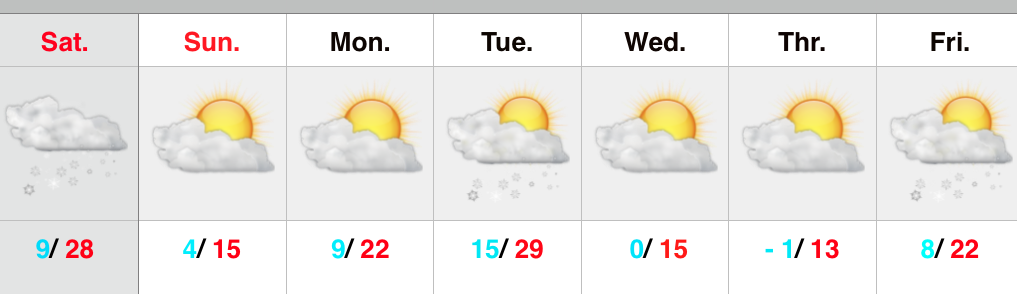
Hope You Like Winter…Many central Indiana neighborhoods are awaking to temperatures this morning between zero and 4 degrees above.  It’s a frigid start to the day and sunshine won’t do anything to help us out as highs only manage to climb into the middle teens.

Clouds will increase this evening and tonight and snow will overspread the southern half of the state late tonight and Monday morning.  This is from the storm system we said that it was too early to write off last week and that a northern shift was certainly possible as we got closer.  Sure enough, the northward jog took place yesterday and puts places from Indianapolis and points south in play for accumulating snow Monday.  We’ll continue to look over the data today and tonight and have more specific numbers later tonight.

Yet ANOTHER surge of arctic air will slam in here by the middle of the week and snow showers/ gusty winds will precede the bitter blast.  In fact, this 3rd arctic surge looks to be the coldest yet.  Amazing stuff!

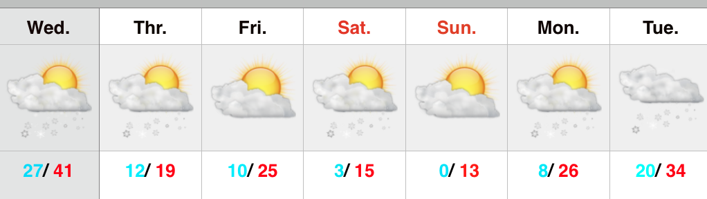
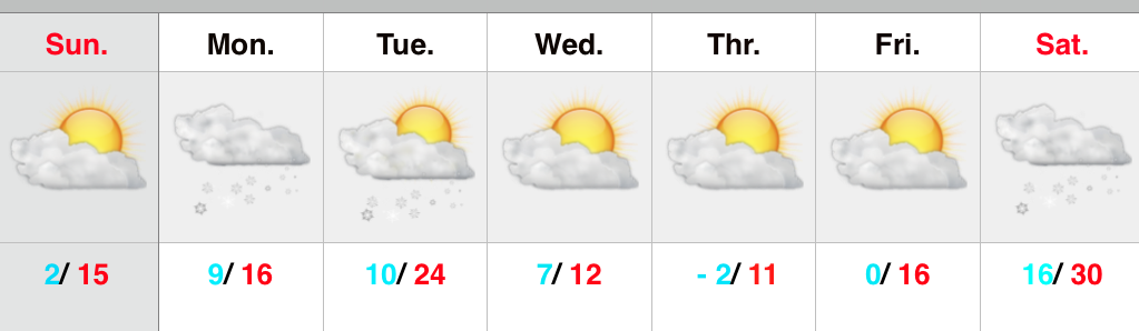
As we rumble towards next weekend, there’s yet another winter storm we’ll have to keep a watch on…

Upcoming 7-Day Precipitation Forecast:

  • 7-Day Rainfall Forecast: 0.00″
  • 7-Day Snowfall Forecast: 2″ – 5″

Permanent link to this article: https://indywx.com/incredible-pattern/

Sustained Frigid Pattern…

Screen Shot 2015-02-14 at 7.47.08 AMArctic Reinforcements…That will be theme of the upcoming 7-days as one arctic blast after another drops into the region.  Considering normal highs are in the upper 30s and lows are in the lower 20s, the majority of days this upcoming week will feature highs colder than our average low.  – Impressively cold both from the absolute temperature, but also the sustained nature.

Today’s arctic attack will be preceded by snow showers and squalls (dusting to less than 1″), strong and gusty winds up to 45 MPH, and dangerous wind chills by afternoon and evening to between 15 and 20 degrees below zero.

We continue to keep an eye on a southern winter storm early next week, but details remain far from etched in stone on the track of the system.  Nearly all guidance keeps snow south of our region, but we note the overall pattern is one that may promote a northward shift in the system over the next day or two.  Is a big snow in our future?  No, but we can’t completely remove the chance of light snow just yet Tuesday.

Yet another arctic blast will drop into town by the middle of the week and that may be the coldest yet…

Upcoming 7-Day Precipitation Forecast:

  • 7-Day Snowfall Forecast: 1″ 
  • 7-Day Rainfall Forecast: 0.00″

Permanent link to this article: https://indywx.com/sustained-frigid-pattern/

Arctic Air Waiting On Deck…

Screen Shot 2015-02-11 at 8.00.54 AMArctic Air And Snow Chances…Today will be the best day of the upcoming seven days, but caution as an arctic front slams into the region late tonight and early Thursday with bitter cold, strong and gusty winds, and scattered snow showers.  Tomorrow will feel nasty with sub-zero wind chills continuing through the day.

Friday will feature dry and cold conditions and we’ll eye Friday night/ early Saturday for the second, and more intense, arctic surge.  Temperatures will fall through the day, winds will be strong, and snow showers will be around the region.  We also note some localized lake effect is possible with both arctic surges and targets northeast and east-central portions of the state for potential lake effect enhancement.  Saturday wind chill values will be 20 to 25 degrees below zero.

Sunday will be dry and cold, but by this time all eyes will be on a winter storm developing to our southwest.  Forecast models vary between a moderate to a significant winter storm and this will require a close eye and fine tuning in the days ahead.

Upcoming 7-Day Precipitation Forecast:

  • 7-Day Rainfall Forecast: Trace
  • 7-Day Snowfall Forecast: 2″ – 4″

Permanent link to this article: https://indywx.com/arctic-air-waiting-on-deck/

Winter’s Back!

Screen Shot 2015-02-09 at 8.09.10 AMLots Of Winter Ahead…After a brief weekend thaw, winter’s set to roar back with authority this week.  Morning freezing drizzle and freezing fog should diminish and give way to a mostly cloudy day.  It’ll be much colder than what we enjoyed over the weekend as temperatures hold nearly steady through the day.

Sunshine returns briefly Tuesday, but another fast-moving weather disturbance will bring a light rain shower Wednesday.  As a shot of arctic air drills in here Wednesday night and Thursday, snow showers will blow into town with gusty winds.

A second and even more intense surge of bitter arctic air will pour south Saturday into Sunday.  Dangerously cold air will be accompanied with this surge, including below zero wind chills and more snow showers.

We’re eyeing early next week for the opportunity of a more widespread winter event.  Stay tuned…

Upcoming 7-Day Precipitation Forecast:

  • 7-Day Rainfall Forecast: Less than 0.10″
  • 7-Day Snowfall Forecast: 1″ – 2″

Permanent link to this article: https://indywx.com/winters-back/

Enjoy Today; Cold Week Coming…

Another mild day is on tap with a southwest flow ahead of a frontal boundary that slips through this evening with light showers. Note the sharp temperature gradient this evening.…

You must be logged in to view this content. Click Here to become a member of IndyWX.com for full access.  Already a member of IndyWx.com All-Access?  Log-in here.

Permanent link to this article: https://indywx.com/enjoy-today-cold-week-coming/