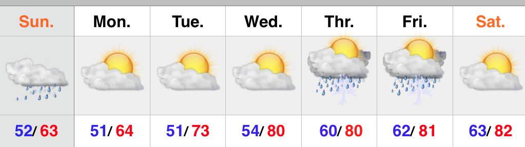
Chilly Now, But Warmer Days Coming…

Screen Shot 2015-06-01 at 10.16.25 PMHighlights:

  • Unseasonably chilly air begins to moderate
  • Dry weather returns
  • Eyeing the next cold front late in the weekend

The past couple of days have felt more like late spring or fall rather than the first day of meteorological summer (June, July, August).  No need to fret, however, as milder air will return beginning Tuesday afternoon…after another very chilly start.  The next couple of days will feature plenty of sunshine!  Enjoy!  Moisture will slowly begin to increase to end the week and an isolated to widely scattered storm chance will accompany the warmer, more humid air.  Best rain and storm chances look to come Sunday as a cold front moves closer.  Drier and cooler air will work back into the region Monday evening.

Upcoming 7-Day Rainfall Potential: 0.50″ – 0.75″

MUCH Cooler Today…

Screen Shot 2015-05-31 at 9.27.05 AMHighlights:

  • Unseasonably cool to open the new week
  • Dry pattern most of the week
  • Storm chances increase late week

Beneficial rains fell across the area Saturday and today we’re left with a cloudy, drizzly, and much cooler regime.  It certainly won’t feel like May 31st and June will also open on a much cooler than normal note.  Jackets will be required this afternoon.  Most of the upcoming week will feature dry skies along with a warming trend once to mid week.  Moisture will increase Thursday and we’ll introduce a chance of scattered thunderstorms Thursday into Friday.

Upcoming 7-Day Rainfall Potential: 0.25″ – 0.75″

Less Humid Today…

Screen Shot 2015-05-28 at 7.29.08 AMHighlights:

  • Less humid today
  • Best rain chances Saturday, but plenty of dry time too
  • Much cooler early next week

High pressure and a northeast flow will help provide a much less humid feel today, but it’ll still be warm.  Moisture will slowly increase again Friday and isolated to widely scattered storm coverage will return.  Best rain and storm chances will arrive Saturday afternoon and evening as a cold front passes through the region, but we want to make sure we also stress there will be plenty of dry time, as well.  The big story early next week will be a MUCH cooler air mass moving into the region.  Models are behaving in an inconsistent manner Sunday in regards to the timing and position of the frontal passage.  As of now, we’re leaning towards the drier solutions, but stay tuned.

Upcoming 7-Day rainfall potential: 1″ to 1.2″

Strong To Severe Storms Possible Tuesday PM…

Screen Shot 2015-05-25 at 7.13.18 PMHighlights:

  • Strong to severe storms possible Tuesday afternoon/ evening
  • Drier skies Thursday-Friday
  • Weekend cold front

hires_ref_indy_28Forecast radar above (courtesy of Weatherbell.com) shows our next weather concern and that has to do with an upper air disturbance moving northeast tonight into Tuesday.  This will likely ignite scattered strong to severe thunderstorms across the area Tuesday afternoon and evening.  Remain weather-aware tomorrow for the possibility of these severe storms. Large hail is the big concern.  Should we see morning sunshine of significance then that would “up the ante” for afternoon severe potential.  We remain in a rather unsettled, warm, and humid pattern this week, but there will be plenty of dry time.  Coverage of thunderstorms Thursday and Friday will be diminished from what we can expect tomorrow and Wednesday.  A cold front will arrive over the weekend, helping to increase shower and thunderstorm coverage.

A blend of short and mid range computer guidance prints out an average of 1.5″-2″ of rain over the upcoming ten days.  This is needed after what’s been several weeks in a row of a lack of widespread rains.

Great Weekend Weather Ahead…

Screen Shot 2015-05-21 at 10.40.39 PMHighlights:

  • Another chilly start
  • Lots of weekend sunshine
  • Rain chances continue to decrease for the Indy 500
  • More humid times next week

Screen Shot 2015-05-21 at 10.43.59 PM


An unseasonably chilly air mass continues to engulf much of the region (shown above).  As we flip the page and head into the long holiday weekend, we’ll note moderating temperatures and increasing humidity levels once to race day.  An isolated or widely scattered storm is possible Sunday, but rainfall coverage continues to diminish with each passing computer model run.  Even if we do see a passing storm Sunday, it’ll likely arrive later in the evening.  A more humid regime will build in here next week and we’ll keep mention of showers and thunderstorms, particularly during the afternoon and evening.  We’ll highlight Tuesday and Wednesday as days with potentially the most widespread coverage of showers and storms.