Category: 7-Day Outlook
 Highlights:
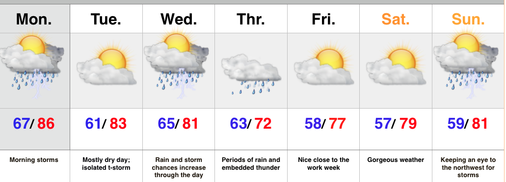
- Monday morning storms
- Wet mid week stretch
- Keeping a watchful eye to the northwest
As we type this, storms are expanding and intensifying in coverage to our north, across the Great Lakes region. We expect these storms to continue to build west as they sink south and southeast with time. As such, don’t be surprised by a predawn wake-up call, courtesy of Mother Nature Monday morning. A few storms could be strong to severe with the primary concern being damaging winds.
After a nice Tuesday, low pressure will track east and provide widespread rain and thunderstorms Wednesday into Thursday. Locally heavy rainfall is a good bet.
Once to late week and the weekend, confidence begins to lower. We’ll remain in a challenging northwest flow and models can struggle in handling specific features. That said, we’re keeping our fingers crossed for pleasant weather to wrap up the work week and head into the weekend, along with well below normal temperatures. Rain and storm chances return Sunday.
Upcoming 7 Day Rainfall Forecast: 2″ – 3″ with locally heavier totals
Permanent link to this article: https://indywx.com/early-morning-storms/
 Highlights:
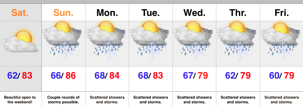
- Beautiful Saturday ahead
- Wet and stormy pattern returns
- Cooler than normal air arrives
We couldn’t ask for a better start to the weekend. Today will feature lots of sunshine, pleasant humidity and temperatures, and absolutely perfect conditions to spend time outdoors! Enjoy because active times return for the second half of the weekend that will carry us into next week.
As promised, we’re heading back into a very busy weather pattern. The hot dome of air (ridge of high pressure) will shift southwest and allow multiple disturbances to ride the outer periphery of the ridge in a northwest to southeast fashion. Each disturbance will be capable of producing periods of showers and thunderstorms- some of which may produce locally heavy rainfall.
As we progress into the latter portion of the work week questions abound. How far does drier air penetrate south? What’s the precise location of the ridge? Both will have to be answered in due time. For now, we’re sticking with an unsettled regime with progressively cooler air. If some of the drier solutions verify then we’ll remove rain and storms altogether once past Thursday and introduce even cooler air. Stay tuned.
Upcoming 7-Day Rainfall Forecast: 1.5″ – 2″ (locally heavier totals)
Permanent link to this article: https://indywx.com/awesome-open-to-the-weekend-wet-pattern-quickly-returns/
 Highlights:
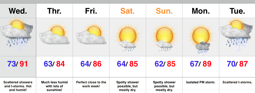
- Thundery Wednesday
- Much more refreshing feel to close the week
- Storm chances return early next week
A cold front will move through the region Wednesday afternoon and evening. The front will slice into a very warm and humid air mass so strong to severe thunderstorms will be possible, especially late morning into the afternoon/ evening. We’re not forecasting widespread severe, but with all of the moisture in the atmosphere, locally heavy rain and additional flash flooding can’t be ruled out.
At any rate, a much more pleasant feel can be expected to wrap up the work week. We note dew points plunge from the upper 70s Wednesday morning into the upper 50s Thursday morning. Talk about nice!
While we have to maintain a mention of a shower over the weekend, the majority will be rain-free. The pesky NW flow aloft may push a weak disturbance into central IN so we have to mention the threat of an isolated shower Saturday into Sunday.
Looking ahead, next week is potentially an active one, including a heavy rain threat followed by a big push of early August cool air.
Upcoming 7-Day Rainfall Forecast: 1.5″ – 2″ (locally higher totals under storms)
Permanent link to this article: https://indywx.com/hot-and-humid-with-storms-but-relief-is-coming/
 Highlights:
- Beauty of a close to the work week
- Humidity and storm chances return this weekend
- Turning hot ahead of a cold front next week
We simply can’t ask for more beautiful weather this time of year than what we’ll enjoy to wrap up the work week. (3 day weekend, anyone)? Make time to spend outdoors today!
Warmth and humidity will be on the uptick this weekend and with the increasingly humid air, isolated to widely scattered thunderstorms can be expected. That said, there’ll be more dry time than not this weekend so there’s no need to cancel any of those outdoor plans.
Heat will build early next week, along with continued “splash and dash” storm coverage- particularly of the PM variety. Best rain and storm chances should come Thursday as a cold front draws near.
Upcoming 7-Day Rainfall Forecast: 0.50″ – 1.00″ (locally heavier totals under stronger storms)
Permanent link to this article: https://indywx.com/cant-ask-for-anything-better-this-time-of-year/
 Highlights:
- Stretch of dry, beautiful, weather continues
- Warming up and turning more humid this weekend
- Isolated storm chances by Sunday
Beautiful weather continues today, thanks to a big area of high pressure. It almost feels like early fall out there this morning (and we’re certainly not complaining).
Overall, we’re looking at dry weather continuing into the weekend. There’s a weak disturbance that will pass Thursday and could spark an isolated shower, but we don’t think this will be a big deal in the least.
Temperatures will be on the uptick this weekend along with humidity levels and isolated to widely scattered thunderstorms can be expected Sunday before better rain chances Monday.
Upcoming 7-Day Rainfall Forecast: 0.50″ -1.00″
Permanent link to this article: https://indywx.com/beautiful-weather-continues/

