Category: 7-Day Outlook
 Highlights:
- Better coverage of Tuesday storms
- Splash and dash storms through the rest of the week
- Hot pattern continues into the holiday weekend
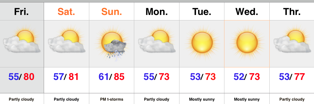
An upper level disturbance will track overhead Tuesday and be responsible for helping kick off more widespread showers and thunderstorms. These will be slow movers and capable of depositing hefty rainfall totals in localized areas. This won’t be a “uniform” rain event by any stretch of the imagination and some locales may not even see a drop of rain.
Coverage of showers and thunderstorms will diminish to “isolated” for mid and late week. The big weather story will be the unseasonably warm regime leading into the holiday weekend. Our next storm of note appears to be on the horizon around a week from today and deliver better rain and storm chances by next Tuesday, along with cooler air.
Upcoming 7-Day Rainfall Forecast: 0.10″ – 0.25″ (locally heavier totals)
Permanent link to this article: https://indywx.com/better-coverage-of-storms-tuesday/
 Highlights:
- Most widespread rain across northern IN today
- Isolated storm possible Sunday
- Warm week upcoming
A weak frontal boundary remains draped to our west this morning and is serving as the focal point for showers from IL into northern IN. As of now, most of central IN is simply dealing with mostly cloudy skies and dry conditions. As we progress into the afternoon we’ll include the mention of scattered showers, but this won’t be a big deal and many will remain rain-free today.
Though isolated showers or storms are possible during the upcoming week, most will remain free of any rain. Temperatures will be very summer-like- not a bad thing as we rumble towards the big Labor Day weekend and the kick-off to the college football season (hard to believe)!
Upcoming 7-Day Rainfall Forecast: 0.10″ – 0.25″
Yesterday was a fantastic day for a hot air ballon ride and the “@cryptics cam” caught just that! Be sure to follow @cryptics on Twitter for awesome views of the sky and associated weather conditions here across central IN!
Permanent link to this article: https://indywx.com/spotty-saturday-showers/
 Highlights:
- Taste of early fall continues (for now)
- Moisture slowly returns this weekend
- Heat builds this weekend and grows hotter next week
After a couple days of variably cloudy skies, we should see more in the way of sunshine as we get set to wrap up the work week. Conditions will remain unseasonably pleasant to be outdoors.
We’ll begin to transition to warmer and more humid times this weekend and with a disturbance nearby, an isolated to widely scattered shower or thunderstorm has to be included in our forecast. Most should remain rain-free, however.
Overall dry and increasingly hot conditions will be the rule next week as ridging develops over the Great Lakes region. Folks longing for more summer before fall truly sets in look to have their wish granted over the upcoming couple weeks ahead.
In the tropics, all eyes remain on Erika. Though many questions remain, folks from the east coast of Florida up along the Southeast coast should remain abreast of the latest developments. It’s likely Erika will go through a strengthening process over the next couple days.
Upcoming 7-Day Rainfall Forecast: 0.10″ – 0.25″
Permanent link to this article: https://indywx.com/early-fall-like-now-but-heat-builds/
 Highlights:
- MUCH cooler than normal, fall feel blows into town
- Dry week ahead
- Moisture and warmth returns for the weekend
A cold front is on the doorstep this evening and will sweep through the region tonight. Ahead of the front we’ll maintain mention of a shower or thunderstorm, but the band of storms coming through will be “broken” and everyone won’t get wet. A MUCH cooler feel will blow into town tonight and remain intact through the balance of the work week ahead- a downright fall feel. Winds will be breezy Monday afternoon out of the northwest.
Moisture and warmth will return as we head into the upcoming weekend along with an isolated to widely scattered thunderstorm chance.
Upcoming 7-Day Rainfall Forecast: 0.10″ – 0.25″
Tonight’s “@cryptics Cam” captures storm clouds gathering to the west as a cold front moves into town. This image was snapped around 4:15p Sunday evening.
Permanent link to this article: https://indywx.com/fall-feel-arrives-tonight/
 Highlights:
- Very nice close to the week
- Sunday storm potential
- Another blast of fall-like air to open the week
High pressure will remain in control of our weather to wrap up the week. As a result look for lots of sunshine and dry air to continue. The next couple mornings will get off to an unseasonably cool start, but the late August sun will help us warm quickly to around 80 today and Saturday. Enough southwesterly flow will be in place Sunday to bump temperatures and moisture levels a “touch.” As a cold front slides into the area we’ll add scattered to numerous thunderstorms into the picture Sunday afternoon and evening. Forecast models vary considerably on rainfall totals, including not much more than one tenth of an inch from the GFS to around an inch with the European. The 12z Canadian is very aggressive suggesting a swath of 2″ through central IN. We’ll discard that solution for now and side with a blend between the GFS and European.
The big story next week is another push of well below normal, unseasonably cool, air! If you aren’t craving fall now then you’re certain to by early next week! (Ah, we’re so close to football season I can hardly stand it).
Upcoming 7-Day Rainfall Forecast: 0.50″ – 1″
Talk about a gorgeous day and an even better sunset! Tonight’s “@cryptics Cam” captures that sunset in crisp, clear fashion. Be sure to follow @cryptics on Twitter for awesome views of the sky and associated weather conditions here across central IN!
Permanent link to this article: https://indywx.com/weekend-moderation-before-another-push-of-fall-like-air/
