Category: 7-Day Outlook
 Highlights:
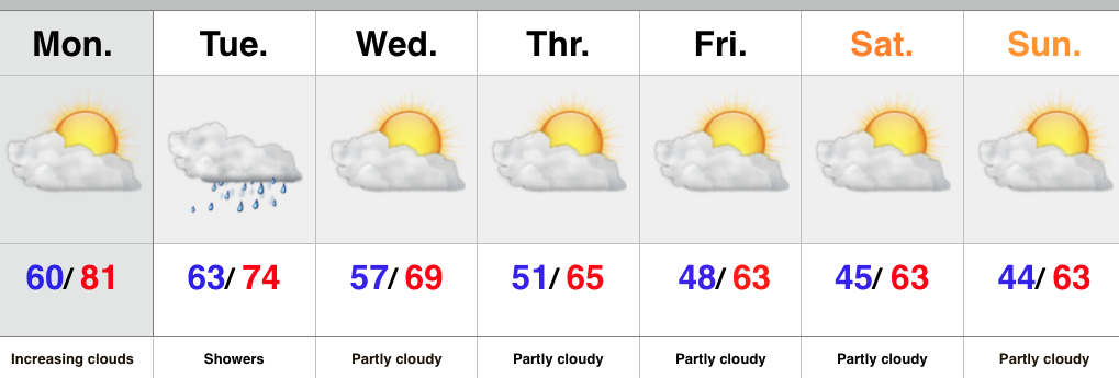
- Increasing clouds
- Shower chances go up tonight
- Much cooler air coming
The work week has gotten off to a pleasant and dry start with sunshine across central IN. That said, a quick look at the satellite shows clouds and moisture streaming north. Expect increasingly cloudy skies as we progress through the second half of the day with showers developing tonight. The region will be in a “squeeze play” of sorts Tuesday as a cold front from the northwest and tropical moisture from the Gulf of Mexico collide. The end result will be locally heavy rainfall downstate with numerous showers extending north into central Indiana, as well.
The cold front will sweep through the region Tuesday night and help usher in a much cooler air mass for the rest of the week, continuing into the weekend. Sweaters and jackets will be needed this weekend.
Upcoming 7-Day Central Indiana Rainfall Forecast: 0.10″ – 0.30″
Permanent link to this article: https://indywx.com/warm-start-to-the-week-but-cool-changes-coming/
 Highlights:
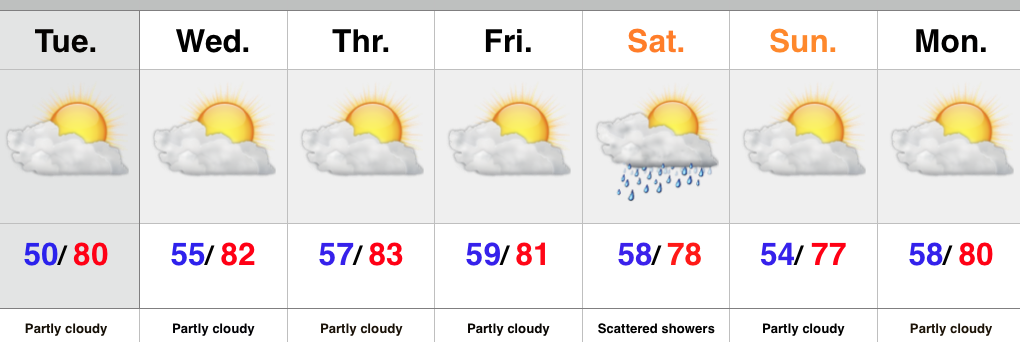
- Clouds increase to wrap up the work week
- Tropical connection courtesy of the Atlantic this weekend
- Midweek cold front
An area of low pressure is slowly tracking north along the SC coast Thursday evening. A surge of tropical moisture will retrograde (that’s for you, Rick ;-)) northwest and result in “showery” weather around these parts to open the weekend. We’re not talking a lot of rain, but expect periodic wet times for central and southern portions of the state Saturday. We’ll maintain mention of a shower Sunday, but Sunday will be the drier of the two days.
We’re back to “high and dry” early next week, but a weak frontal boundary will move through here late Wednesday with a broken band of showers. Not everyone will see rain Wednesday. Slightly cooler air will arrive late next week.
Upcoming 7-Day Rainfall Forecast: 0.10″ – 0.30″
Permanent link to this article: https://indywx.com/clouding-up-saturday-showers-arrive/
 Highlights:
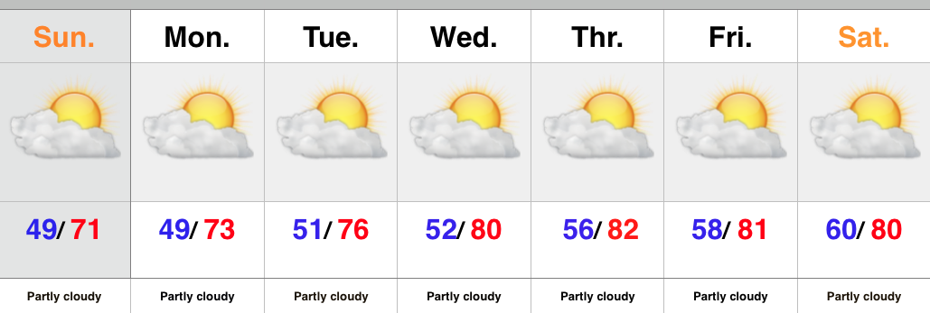
- Dry conditions continues
- Temperatures warm
- Weak front Saturday
It’s a very boring forecast as high pressure remains in control through the short-term. This will continue to promote dry conditions. Moderating temperatures can also be expected as our air flow backs around to the SW with time.
The only item of significance in this 7-day is a weak frontal boundary that will move through here with scattered showers Saturday. Slightly cooler air will push in behind the boundary, but it’s an overall very warm pattern.
Upcoming 7-day Rainfall Forecast: 0.10″
Permanent link to this article: https://indywx.com/warm-and-mostly-dry-forecast/
 Highlights:
- Dry conditions return
- Moderating temperatures through the week
There’s no reason to waste a bunch of pixels on the forecast ahead. High pressure is building in behind the cold front that moved through here Saturday morning. As a result expect dry skies and mostly sunny conditions into next weekend. The cooler, fall-like, air of the weekend will begin to moderate back to summer-like levels into the latter portion of the upcoming work week.
Upcoming 7-Day Rainfall Forecast: 0.00
Permanent link to this article: https://indywx.com/back-to-a-dry-pattern/
-
Filed under 7-Day Outlook, Autumn, Forecast Discussion, Forecast Models, Rain, Severe Weather, Summer, T-storms, Unseasonably Cool Weather, Unseasonably Warm
-
September 18, 2015
September to date has been drier and warmer than average across the region- right as planned thus far, overall. This morning featured a more aggressive push of showers…
You must be logged in to view this content. Click Here to become a member of IndyWX.com for full access. Already a member of IndyWx.com All-Access? Log-in here.
Permanent link to this article: https://indywx.com/a-look-where-weve-been-and-where-were-going/
