Category: 7-Day Outlook
 Highlights:
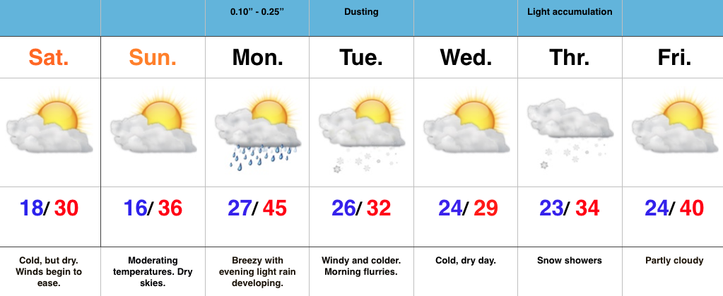
- Cold, but dry weekend
- Weak system delivers showers/ flurries early week
- Models disagree on clipper track
Cold, But Lots-O-Sunshine…A major winter storm is hammering areas still from the southern Appalachians into the Mid Atlantic and Northeast. Light flurries fell across central IN Friday evening, but drier air quickly built into the region overnight and sets the stage for a cold, but sunny weekend. Gusty NE winds that were felt Friday and overnight will also begin to diminish today.
Our next weather maker will blow into town Monday, but will be weak. Showers will accompany the frontal passage Monday evening before snow flurries/ light snow showers fly in the cold air advection Tuesday morning. All in all, this won’t be a big deal.
The next potential “trouble maker” awaits for the middle part of the week, but caution model data is all over the board on the eventual track of this clipper system. We’ll lean more towards the Canadian solution at this juncture (model of choice with clippers) and forecast snow showers to build into central IN Thursday. From this distance, model solutions range from snowy (light accumulation) to dry and mild. We wouldn’t have it any other way this winter. 
Permanent link to this article: https://indywx.com/dry-weekend-clipper-snow-next-week/
 Highlights:
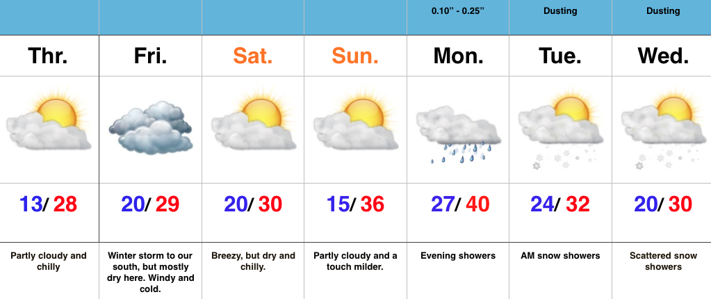
- Cold, dry, and increasingly windy
- Heavy snow across far southern IN
- Weak system Monday
Watching A Major Winter Storm To Our South…As busy as things will be for our friends to our south and east, the weather, locally, will be about as quiet as we can expect this time of year. Hefty (and in some cases crippling) snows will fall to our south and southeast. Here on the home front we can expect a day with mixed clouds and sun today before we turn mostly cloudy Friday. We’ll feel the “outer impacts” of the major winter storm to our south Friday in the form of strong and gusty east winds that slowly begin to diminish Saturday. Sunday looks beautiful and it’ll feel downright balmy when compared to the bitterly cold air of late.
Our next weather maker is looking less and less impressive and will deal a few showers Monday followed by cold air returning Tuesday and Wednesday with scattered snow showers. – Doesn’t look like a big deal in the least from this distance.
Permanent link to this article: https://indywx.com/action-to-our-south-relatively-quiet-here/
 Highlights:
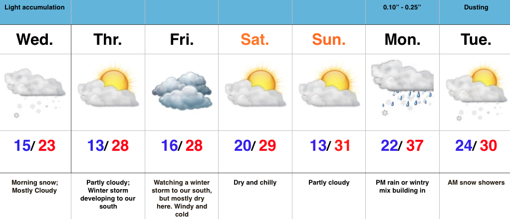
- Snowy morning
- Major winter storm impacts the southern Appalachians into the Mid Atlantic
- Dry, cold weekend in store
Snowy Morning; Next Winter Storm Shifts South…This morning’s snow “behaved” as planned with a quick thumping across a large portion of central IN. A quick scan of accumulation reports into the office this morning indicate amounts, on average, right around 2″ (some a bit more, some a little less). We’ll recap later this evening, with an overlay of our snowfall forecast map. Due to the timing of this event, this morning’s commute is a nightmare, as expected.
As we look ahead, the major winter storm (crippling for some) late week is trending further and further south. Now, instead of the initial low tracking through the TN Valley (which would’ve argued for a reflection of the low up west of the mountains), it appears to stay so far south that it tracks along the northern Gulf states before the primary low takes over and delivers the “snowy goods” to our friends from the east TN mountains north and east. By the way, this will be a monster event for the southern Appalachians (yard stick will be needed to measure the final product). Back here on the home front, we’ll forecast a dry, cold stretch with a blustery Friday (east winds gusting 20-30 MPH).
Our next weather maker of note will come early next week. More on that as we draw closer.
Safe travels and happy snow to all! 
Permanent link to this article: https://indywx.com/snowy-morning/
 Highlights:
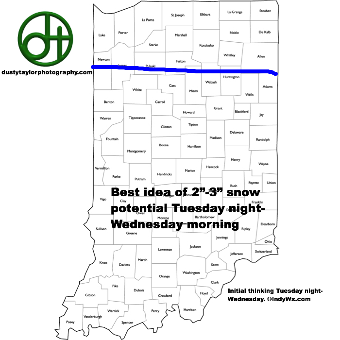
- Frigid day
- Accumulating snow Tuesday night-Wednesday
- Late week winter storm threat south
- Active pattern continues next weekend
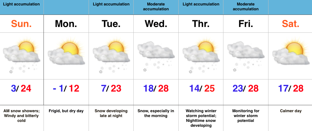
Bitterly Cold With Developing Snow Tuesday Night…It’s a bright, but frigid start to the day with mostly sunny skies in place. Temperatures are below zero for many this morning and ‘chills have dipped to as low as 20 below. If you have to be out today, layer up and limit time outdoors.
Clouds will quickly be on the increase Tuesday afternoon and snow will develop Tuesday night, continuing into Wednesday morning. Model data suggests snow may come down at a good clip at times early Wednesday morning. The initial snowfall map (below) places our best idea on accumulation for now. As we always say, this should be used as guidance at this distance and we’ll have to fine tune as we move forward.
The consensus of nearly all model data shifts our late week winter storm further south overnight. It’s too early to write this storm off, but we’ll trend our forecast drier in the Thursday-Friday time frame for now (that blocking high to our north can, at times, be a blessing and a curse ;-)). Another chance of snow rumbles in late in the weekend.
Permanent link to this article: https://indywx.com/frigid-day-watching-accumulating-snow-threat-tomorrow-night/
 Highlights:
- Frigid stretch of weather
- Accumulating snow mid week
- Winter storm potential late week
Busy Winter Pattern…Frigid air is helping usher in the new week and this morning’s snow bursts are setting the tone for potentially “more important” snow events in the days to come.
First things first though and that’s today. Morning snow showers and heavier squalls will diminish and give way to an absolutely bitter feel for the afternoon. Highs today took place at midnight and will continue to plummet through the day. We’ll be in the single digits by dinner. Wind chill values tonight and Monday will reach 20 degrees below zero. Ouch!
All eyes will then shift to an approaching mid week snow maker and this should be a “plowable” event for most. We expect a swath of snow to roll through central IN late Tuesday night into Wednesday morning.
Just as soon as the mid week snow maker moves out, we’ll have to turn our attention to late week. There are many questions regarding the northward extent of snow with this storm, but the overall set-up from this distance has to put a smile on the faces of Ohio Valley snow lovers. The blocking high to the north will be sufficient to supply cold air at the surface as moisture is supplied from the Gulf of Mexico, but it will limit how far north the low will track. Is this an Ohio Valley or TN Valley event? Ensemble data at the moment leads us to believe this will track far enough north to impact our region. We’ll have to sort through additional details in the coming days.
Permanent link to this article: https://indywx.com/active-wintry-week-ahead/
