Category: 7-Day Outlook

Stormy Evening…

Screen Shot 2016-02-02 at 7.24.07 AMHighlights:

  • Strong to severe storms this evening
  • Rain and snow showers Wednesday
  • Dry and chilly to wrap up the work week
  • Nice weekend ahead
  • MUCH colder next week

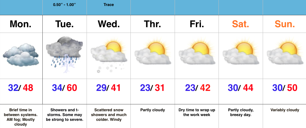
Stormy Evening…Tuesday is dawning nice and quiet with dry and chilly conditions in place.  A bit of fog has been reported just west and north of the city.  The quiet times will give way to a bumpy ride by this evening as a warm front passes, allowing a strong SW breeze to boost temperatures close to 60 (after dark high).

Scattered showers will develop this afternoon, but it’s the evening hours that we bracket (between 4-10p west to east) for the potential of strong to severe storms.  Some of these storms will be capable of damaging winds, and even a quick spin-up tornado can’t be ruled out.  Have a way to get the latest weather information this evening.

We turn cooler Wednesday with lingering moisture falling in the form of mixed rain and snow showers.  This won’t be a big deal.

Dry times will be with us to end the week and rumble into the Super Bowl weekend, with moderating temperatures.  The moderating trend won’t last long as models continue to suggest an arctic blast looms next week.  To go along with that cold, snow chances will also come.

Permanent link to this article: https://indywx.com/stormy-evening/

Strong To Severe Storms Tuesday PM…

Screen Shot 2016-02-01 at 7.03.14 AMHighlights:

  • Morning fog in spots
  • Strong Tuesday storms
  • Mid week snow showers
  • Quiet end to the week

Strong To Severe Storms Tuesday Afternoon-Evening…Today is a day in between storm systems. We’ll deal with morning fog in spots (some freezing fog is being reported north and northwest of Indy this morning) and mostly cloudy skies.  It’ll be colder when compared to the weekend, but still warmer than average.

All eyes for this forecast package remain locked on Tuesday.  It’s still shaping up to be an active day, with strong to severe thunderstorms likely.  We bracket 3p-11p for the most likely time frame of thunderstorms across central IN.  Damaging straight line winds are of greatest concern, but caution a few embedded cells will be capable of producing a tornado.

Things turn much colder Wednesday and with lingering moisture, a few snow showers will be a good bet.

We turn much quieter to wrap up the week and head into Super Bowl Sunday.

Permanent link to this article: https://indywx.com/strong-to-severe-storms-tuesday-pm/

Taste Of Spring Today, But Winter Roars Back…

Screen Shot 2016-01-30 at 9.32.06 AMHighlights:

  • Active period of weather ahead
  • Spring-like now turns much colder
  • Storms in between
  • Snowy February ahead?

Taste Of Spring Today, But Winter Roars Back…A quick scan over the 7-day above shows the busy times that lie ahead.  Our suggestion to you?  Enjoy today’s sunshine and early taste of spring!  Let us worry about what lies ahead.  You’re welcome!  😉

We’ll add some mid and high level cloudiness into the picture later today and those clouds will lower and thicken tonight.  Tomorrow, though still warm, won’t be as nice.  Look for cloudy skies, scattered showers, and breezy SW winds.

We’ll be in between systems Monday with a generally dry day and a bit cooler, though still above average for this time of year.

A strong area of low pressure will quickly move from the central Plains Monday night into the Great Lakes Tuesday night.  We’ll be on the warm side of this storm’s track and will note a dramatic shift in our wind to the SW early Tuesday that will help temperatures zoom into the lower 60s Tuesday.  The downside?  We’ll have to monitor things closely for strong to severe thunderstorm potential.

The area of low pressure will swing a cold front through here late Tuesday night and send temperatures into a free-fall for mid week.  We’ll have to watch things closely as we’ll be in an active NW flow heading into next weekend.  You know the drill by now- models struggle picking up pieces of energy plenty capable of producing accumulating snow from this distance with that potentially active NW flow.

Longer term, winter fans should really like what we’re seeing.  We’ll have a more extensive post on this later in the weekend, but the pattern shaping up is one that’ll feature the more sustained cold pattern (relative to normal) in the middle of the country through most of February, including the Ohio Valley.  A busy interior storm track is also noted in the coming weeks.  Far too early for specifics, but it’s a pattern plenty capable of leading to above normal monthly snowfall in our neck of the woods.  Again, more later!

Permanent link to this article: https://indywx.com/taste-of-spring-today-but-winter-roars-back/

Colder Today With Flurries…

Screen Shot 2016-01-26 at 7.22.15 AMHighlights:

  • Breezy and colder with flurries
  • Fast-moving clippers to our north
  • Mild and increasingly damp weekend

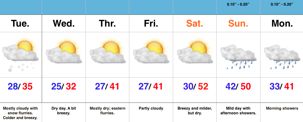
Colder Today With Flurries…A cold front passed through central IN during the overnight and gusty NW winds are greeting us out the door this morning.  A few flurries or light snow will likely fly later this morning and this afternoon.

As we progress into mid week, we’ll eye a couple of fast moving clipper systems to our north.  For the most part, central IN will be left out of any impacts, aside from a gusty SW wind from time to time.  A few flurries may clip eastern parts of the state Thursday.

The upcoming weekend will be a warm one, considering we’re in late January.  Moisture will begin to increase Sunday with clouds and light rain the result.

Permanent link to this article: https://indywx.com/colder-today-with-flurries/

Evening Showers; Relatively Quiet Week…

Screen Shot 2016-01-25 at 7.43.54 AMHighlights:

  • Evening light rain
  • Clipper watch
  • Mild weekend ahead

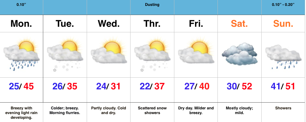
Evening Showers…A weak cold front will press through central IN tonight.  Moisture return isn’t impressive with this system, but light showers will scoot through the area this evening.  Rainfall amounts won’t add up to much.

A few flurries may fly Tuesday morning as cold air moves back into the area.  Temperatures during the day time Tuesday will be below freezing for the most part after a predawn high.

Forecast models still disagree with the overall track of a clipper system Thursday.  The GFS and European models don’t suggest we deal with any snow, whatsoever.  Meanwhile, the Canadian model remains consistent on Thursday snow showers.  Either way, this shouldn’t be a big deal.  We’ll keep an eye on things.

The weekend will shift unseasonably mild as we get into a strong SW flow.  We’ll eye a developing strong storm across the Plains early next week…

Permanent link to this article: https://indywx.com/evening-showers-relatively-quiet-week/