Category: 7-Day Outlook
 Highlights:
- Embedded Tuesday squalls!
- Fast moving NW flow!
- Bigger winter threat to close the week and again late weekend?
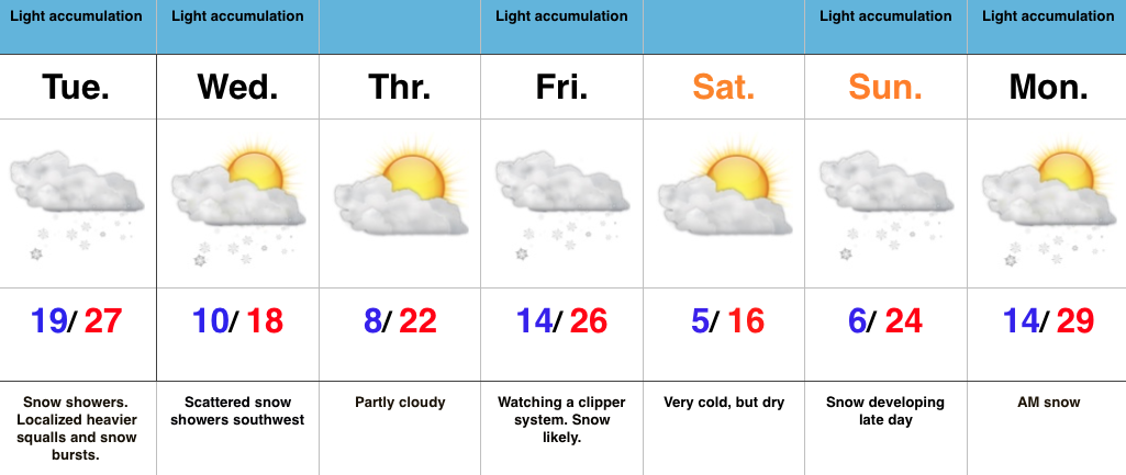
Busy, Cold Winter Pattern…The short term will continue to be dominated by a slow moving upper low over the region. Individual “spokes” (disturbances) of energy will rotate around the upper low and provide enhanced snow showers and embedded heavier squalls through Tuesday night. As promised, there will be “haves” and “have nots” with this system and, in general, we still like the idea of most folks in the 1″-3″ range with a few isolated heavier totals.
This is a challenging northwest flow and can wreck havoc on the timing front. Our best idea right now takes a disturbance southeast Wednesday, but this should remain a touch too far west to prevent much more than our southwest tier counties from seeing much, if any, snow.
A stronger clipper may deliver accumulating snow to wrap up the work week and then we also have our late weekend winter event to fine tune. Get the idea we’re locked into a busy time of things? 
Interested in our detailed consulting services? E-mail bill@indywx.com for further details.
Permanent link to this article: https://indywx.com/busy-cold-winter-pattern/
 Highlights:
- Long duration snow shower event
- Heavier snow squalls possible Monday night-Tuesday morning
- Another push of snow late week
- Bigger winter storm potential at the end of the period
Long Duration Snow Shower Event…A cold front will move through the area late tonight and may be accompanied by a shower or sprinkle as it moves through the region. Colder air will filter in behind the boundary after midnight and snow showers will begin to blossom Monday morning. This will be the beginning of a solid 48-60 hours of snow falling across most of central IN. We think heavier snow bursts and embedded squalls are a good bet Monday night into Tuesday morning as the true arctic air begins to push into the area. With so much upper level energy around, snow showers will continue into Wednesday.
As far as accumulation goes, we think the majority of central Indiana will accumulate 2″-3″ during the early week event, but this won’t be a uniform snow at all (there will be “haves” and “have nots”). Locally, there will also be a few 4″ reports.
Though timing is a challenge in this fast, active northwest flow, we think we’ll be dry and cold Thursday before snow returns to close the work week as another disturbance and reinforcing arctic air move south.
Well below normal cold remains entrenched across the region for Valentine’s weekend, and we note wintry “fun and games” brewing to our west Saturday night into Sunday. We’ll forecast a lowering and thickening cloud deck here Sunday with snow developing during the afternoon and evening. Early indications continue to suggest this could be a storm of “importance” around these parts… Stay tuned.
Permanent link to this article: https://indywx.com/long-duration-snow-shower-event-hope-you-like-winter/
1.) Be sure to get outside and enjoy today! We’ll take sunshine this time of year any how we can get it! Big changes loom moving forward. While Super Bowl…
You must be logged in to view this content. Click Here to become a member of IndyWX.com for full access. Already a member of IndyWx.com All-Access? Log-in here.
Permanent link to this article: https://indywx.com/saturday-afternoon-rambles/
You must be logged in to view this content. Click Here to become a member of IndyWX.com for full access. Already a member of IndyWx.com All-Access? Log-in here.
Permanent link to this article: https://indywx.com/friday-evening-video-update-4/
 Highlights:
- Nice close to the work week
- Enjoy a mild weekend
- Much colder next week with snow
Not A Bad Weekend; Winter Returns Next Week…Weak ridging will be with us as we close out the work week. This will supply a very nice Friday, after some freezing fog concerns in spots early.
The upcoming weekend will feature a weak weather maker scooting through here Saturday and that could have just enough “umph” to produce a flurry or sprinkle. Otherwise, look for mild weather for Super Bowl weekend. Enjoy it!
A cold front will push through the region late Sunday. A band of moisture will likely accompany this front- rain to snow type deal. As we move into early and mid next week, the weather pattern will be dominated by strong western ridging and a significant eastern trough. Models will likely continue to struggle handling the specifics concerning timing and strength with the individual disturbances and we’ll have to keep a close eye on early to mid next week moving forward. As it stands now, we think most widespread snow showers/ squalls come Monday into Tuesday.
Permanent link to this article: https://indywx.com/not-a-bad-weekend-winter-returns-next-week/
