Category: 7-Day Outlook

Mid Week Snow Storm For Parts Of The Area…

Screen Shot 2016-02-22 at 7.32.33 AMHighlights:

  • Nice open to the week
  • Mid week winter storm for parts of the area
  • Wind and heavy, wet snow

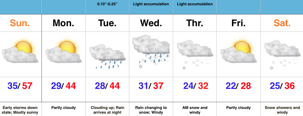
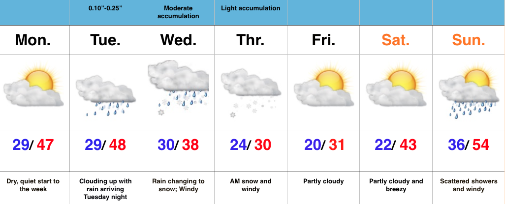
Mid Week Snow Storm For Parts Of The Area…Today is easy!  Weak high pressure will supply dry skies and a quiet time of things, but trouble’s lurking for mid week.

Clouds will increase Tuesday and rain will move in Tuesday evening as a developing storm system lifts northeast out of Texas, into the TN Valley, and into the eastern Ohio Valley.  Long term Hoosiers know that’s a classic track for a snow hit here across central IN and that will likely ring true for portions of the area Wednesday evening into Thursday.  We forecast rain to transition to a heavy, wet snow from northeast to southwest Wednesday afternoon into the evening.  There’s still fine tuning ahead, but as things stand now, this could be a significant event (6″+) for some central and northern IN neighborhoods.  Stay tuned.

The other component of this storm will be a strong and gusty northeast wind that eventually shifts to the north and northwest Wednesday into Thursday.  Cold conditions will be with us to wrap up the work week as the big dig begins for some.

2:23:16-2:25:16Initial

Permanent link to this article: https://indywx.com/mid-week-snow-storm-for-parts-of-the-area/

Nice Finish To The Weekend; Mid Week Storm Brewing…

Screen Shot 2016-02-21 at 10.39.59 AMHighlights:

  • Beautiful finish to the weekend
  • Mid week storm brewing with many questions
  • Snow potential for some
  • Colder pattern developing

Nice Finish To The Weekend; Mid Week Storm Brewing…A disturbance responsible for overnight/ early morning thunderstorms and heavy rain across southern IN is tracking east.  Drier air is working in now and we’ve dialed up a beauty of a close to the weekend across central IN.

The work week will get started on a quiet note, but trouble is brewing for mid week as a big storm system lifts out of the southern Plains and into the lower Ohio Valley.  We forecast a lowering and thickening cloud deck Tuesday followed by rain developing.  As colder air gets pulled into the system, rain will begin to transition to a heavy, wet snow across portions of the area.  Exactly who sees the transition and when remain in question and will have to be fine tuned as time goes along.  That said, the potential is there for a heavy, wet snow “thump” across a portion of our area.  Stay tuned.

This storm will set things into a much colder and rather active time to close the work week and head into next weekend.

Permanent link to this article: https://indywx.com/nice-finish-to-the-weekend-mid-week-storm-brewing/

Messy Monday Morning Commute; Watching Tuesday…

Screen Shot 2016-02-14 at 9.45.26 PMHighlights:

  • Freezing drizzle to start the day
  • Watching another storm system Tuesday
  • Mild and windy close to the week

Messy Monday Morning Commute; Watching Tuesday…After the snowy Valentine’s Day across the region, we’re concerned freezing drizzle will develop and add to what already will be a slick commute in spots overnight and Monday morning. Allow extra drive time and take it slow.

Attention will quickly shift to Tuesday as a vigorous piece of upper level energy dives southeast. We have to fine tune the track later Monday, but this has the potential to spread a swath of accumulating snow over portions of the state Tuesday afternoon and evening.  Stay tuned.

We turn windy, but much milder to wrap up the work week. Friday and most of the weekend will feature a taste of spring as a strong SW flow takes hold and helps pump well above normal temperatures into the area.  Don’t get used to the mild air, as cold will return to wrap up Feb and head into March.

Interested in our consulting services?  E-mail bill@indywx.com for more information.

Permanent link to this article: https://indywx.com/messy-monday-morning-commute-watching-tuesday/

Bitterly Cold; Accumulating Sunday Snow…

Screen Shot 2016-02-12 at 9.23.20 PMHighlights:

  • Bitterly cold
  • Light accumulating snow Sunday
  • Active pattern continues, but with questions

Bitterly Cold; Accumulating Sunday Snow…We label the cold that we’ll deal with Saturday “hurt your face” cold.  It’ll be a bitter day with lows in the lower-mid single digits (even some areas below zero), a biting NW wind, and AM lake-generated snow streamers across eastern portions of the state.  Bundle up, friends!

We still track accumulating snow for Valentine’s Day.  Clouds will lower and thicken Sunday morning and snow should overspread the area as we progress into the late morning hours.  The potential of a plowable snow still looks good from this distance, and we’ll have our initial snowfall map out later Saturday (want to get a look at the full 00z suite before issuing).

Right on the heels of Sunday’s snow maker will be another disturbance Tuesday. Modeling differs on the track (surprise, surprise ;-)), but the potential is there for additional accumulating snows Tuesday into Wednesday.  Stay tuned.

After a final disturbance Wednesday (with light snow potential), we’ll see a marked wind shift to the south to close the week, followed by a brief, but impressive, surge of milder air.

Permanent link to this article: https://indywx.com/bitterly-cold-accumulating-sunday-snow/

Very Cold; Eyes On Sunday-Monday…

Screen Shot 2016-02-10 at 7.10.06 AMHighlights:

  • Scattered snow showers continue
  • Reinforcing arctic air arrives Friday-Saturday
  • Winter storm brewing for some Sunday-Monday
  • Moderating temperatures next week

Very Cold; Eyes On Sunday-Monday…We’ve been dealing with snow showers for over 48 hours.  As expected, accumulations haven’t been uniform, but range, on average, from 1″ to 3″ across central IN.  Morning snow showers continue before drier air will invade from the west and shut the snow production off this afternoon.

Tomorrow will be a dry, cold day before arctic reinforcements arrive Friday into Saturday. Snow showers will accompany the arctic express to close the work week.

Saturday looks brutal. Very cold and windy with below zero wind chills most of the day.

Focus continues on Sunday and Monday and we forecast snow to overspread the area late Sunday night, continuing into Monday.  It’s still early, but this may be a “more important” event, locally.  This will actually come on the “tail end” of the arctic air mass that will have engulfed the region over a week by that point.  We think next week is much milder before we reload the cold to close February and head into March.

Permanent link to this article: https://indywx.com/very-cold-eyes-on-sunday-monday/