Category: 7-Day Outlook
Highlights:
- Snow changes to rain
- Dry close to the work week
- Warm, but wet pattern develops next week
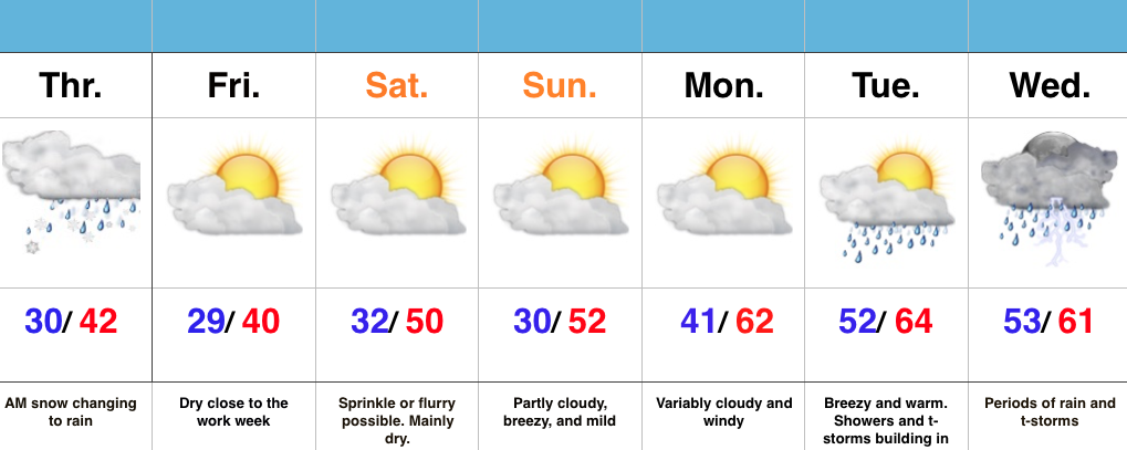
Snow Transitions To Rain…Snow spread over central IN during the overnight and most neighborhoods accumulated between 1″-2″. Warm air advection will result in snow transitioning to rain from south to north as we progress through the late morning hours. All in all, it’ll be a raw Thursday.
Weak high pressure will build in and result in dry conditions Friday with sunshine returning.
A fast moving system will clip the region Saturday with a sprinkle or flurry possible, but this doesn’t appear to be a big deal in the least.
The bigger story? The developing unseasonably warm period developing next week, but we caution this will also be a wet period as a prolonged SW flow transports moisture-rich Gulf of Mexico air into the region. Heavy rain totals will be a good bet.
Permanent link to this article: https://indywx.com/snow-transitions-to-rain/
 Highlights:
- Cold, dry midweek
- Snow changes to rain for central IN Thursday morning
- Much warmer times coming
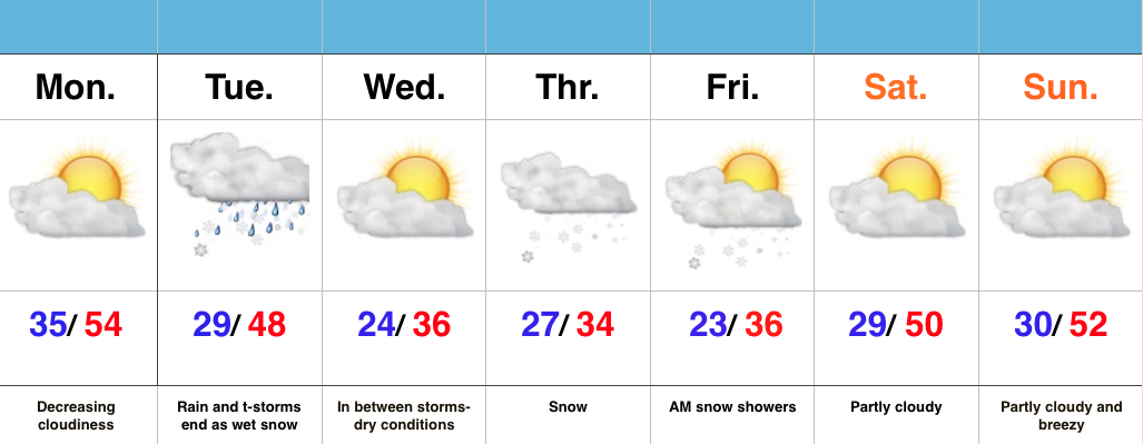
Slushy Snow Late Tonight For Some…It’s a much colder feel out the door this morning! You’ll want the heavier coat. The good news? Dry conditions today, including lots of sunshine.
Our next fast moving storm system will spread snow into central IN during the overnight (after midnight for most) and accumulate for some (snowfall forecast below). For the city, itself, look for a slushy coating to 1″. Further north, a band of 1″-3″ is expected before the transition to rain mid to late morning. Northern IN will be the “winner” with this system, including a 3″-5″ band. All precipitation will be to our east by Thursday evening.
A dry close to the work week is expected before another fast moving storm system deliver a sprinkle Saturday, but this just doesn’t look to be a big deal at the moment. We’ll keep an eye on things.
We turn much warmer early next week, but clouds and showers may keep us from being as warm as we could’ve been otherwise. Better rain and storm chances arrive late Tuesday. A stiff southwest wind will be with us early next week.
 For more in-depth and frequent video discussions and long-range forecasts, e-mail bill@indywx.com for details on our consulting options.
Permanent link to this article: https://indywx.com/slushy-snow-late-tonight-for-some/
Highlights:
- Increasing sunshine today
- Rain/ embedded thunder end as snow Tuesday
- Accumulating mid week snow
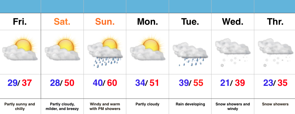
Busy Pattern This Week…After a windy and warm Sunday, a thin band of showers and embedded thunder moved through central IN last night. This was in association with a weak frontal boundary that will provide a dry start to the work week. Despite a cloudy start, sunshine should quickly develop as clouds decrease.
Quiet times won’t last long as our next storm system delivers showers and thunderstorms Tuesday. Colder air will quickly punch in here Tuesday afternoon and evening helping precipitation transition to wet snow before ending. We think the significant accumulations will remain north of central IN, but we’re keeping a close eye on things, nonetheless. Expect an evening update.
Busy times remain in the mid week period as a wave of low pressure spreads widespread snow across the area Thursday. Early indications would suggest this may be a plowable snow for some of the region.
As it stands now, moderating conditions and increasing sunshine are expected heading into next weekend. Longer term, a big ridge should develop across the area later next week. It’s a pattern supportive of anomalous warmth to the tune of 75-80 degrees….
Interested in our consulting options and personalized discussions to your business needs? E-mail bill@indywx.com for more information.
Permanent link to this article: https://indywx.com/busy-pattern-this-week/
Highlights:
- Dry, chilly close to the week
- Milder weekend
- Eyeing a mid week storm
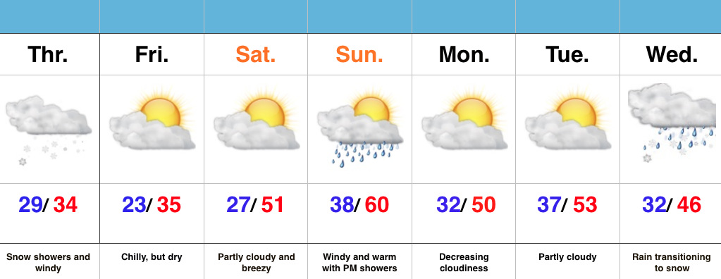
Milder Weekend Ahead…Scattered flurries are flying across northeastern and eastern parts of the state this morning, but drier air is invading from the west and this should lead to increasing sunshine through the afternoon.
Though Saturday won’t be as warm as Sunday, it’s our pick of the weekend with lots of sunshine and mild temperatures. We’ll add wind and evening showers into the mix Sunday.
The next storm of significance is slated to arrive Tuesday. Though we’ll have to fine tune details as we move forward, for now we’ll go with developing rain Tuesday followed by a transition to snow showers Wednesday. Stay tuned.
Indications late next week are that we may have to deal with an active NW flow and snow-producing clippers.
Permanent link to this article: https://indywx.com/milder-weekend-ahead/
Highlights:
- Snow showers and windy
- Dry, chilly close to the week
- Turning milder this weekend
- Next storm lining up the middle of next week
Snowy Thursday; Milder Weekend…Windy and periodically snowy conditions will be with us today, especially this morning. Drier air will win out later tonight and set the stage for a chilly, but dry close to the work week.
Temperatures will get several positive boosts in the right direction just in time for the weekend. Despite a bit of a breeze Saturday, sunshine and lower 50s will be great! Things turn increasingly windy Sunday with afternoon/ evening showers possible.
Our next item of “interest” moves in the middle of next week. It’s far too early for specifics, but some data is eerily similar to our most recent event…
Permanent link to this article: https://indywx.com/heading-in-the-right-direction-for-the-weekend/
