Category: 7-Day Outlook
 Highlights:
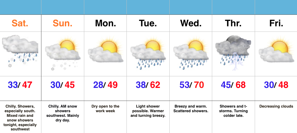
- Dry, chilly open to the week
- Unsettled mid week
- Watching Easter
Ice Scrapers Needed This Morning…Many Indiana neighborhoods awoke to temperatures in the 20s this morning. Thankfully, that late March sun angle will help boost temperatures quickly today to around 50 for afternoon highs.
A warm front will lift through the region Tuesday and could spark a shower or two, but most will remain dry. We’ll turn briefly milder Tuesday and Wednesday before better coverage of showers and embedded thunder arrive on scene Thursday. This is in association with a cold front that will deliver a quick pop of colder air to close the week, including Good Friday. There’s the chance enough cold air could catch lingering moisture to allow for a few snow showers late Thursday night before we dry things out completely.
As we look ahead to Easter, another storm system will arrive quickly. As such, we’re forced to increase rain chances (and coverage) Easter Sunday.
Longer term, indications continue to point towards a rather rude open to April, including well below normal temperatures.
Permanent link to this article: https://indywx.com/the-ups-and-downs-of-spring/
-
Filed under 7-Day Outlook, Forecast Discussion, Forecast Models, PSD, Rain, Spring, T-storms, Unseasonably Cool Weather, Unseasonably Warm, Weather Rambles
-
March 20, 2016
1.) Indianapolis is running much warmer (+9.1°) and slightly drier than normal (-0.15″) month-to-date. 2.) Snow is flying to our southwest, and accumulating for some in and around St.…
You must be logged in to view this content. Click Here to become a member of IndyWX.com for full access. Already a member of IndyWx.com All-Access? Log-in here.
Permanent link to this article: https://indywx.com/sunday-weather-rambles/
 Highlights:
- Chilly, showery weekend- especially south
- Wet snow mixes with rain tonight into early Sunday morning
- Turning warmer by mid week
- Late week showers and storms
Chilly Weekend…We’re dealing with a much colder feel this weekend (jackets and coats required as you venture out to watch the “madness” at your favorite local spot later today). That said, not all of the region will deal with precipitation. This morning into the early afternoon, showers will be most widespread from Indy and points south. Later tonight, another band of precipitation will develop in association with upper level energy, but mainly be confined to the western and southwestern parts of the state. It’s within this band, that we expect wet snow to mix in. With the exception of some early morning snow showers tomorrow, drier air should win out for the majority of the day. It’ll remain colder than normal.
We’ll open the work week on a chilly, dry note, but a warm front will lift through the state Tuesday. A quick-hitting shower is possible as the front lifts north, but the bigger deal will be a noted SW wind shift (it’ll turn gusty) and a much warmer feel by afternoon/ evening. Better chances of showers and thunderstorms will rumble into the state Thursday before we turn quickly colder by Good Friday.
Interested in more in-depth long range forecast discussions, video updates, ag. forecasts, and seasonal outlooks? E-mail bill@indywx.com for more information.
Permanent link to this article: https://indywx.com/chilly-weekend/
 Highlights:
- Mostly dry close to the work week
- Rain to snow this weekend
- Quickly warmer early next week
Keep The Jackets Nearby…We’ve enjoyed April and May-like temperatures over the past couple weeks, so you knew we had to make up for the warmth sooner or later. Thankfully, the pending weekend chill isn’t anything we can’t handle. That said, it will serve as a rather rude shock to the system for those craving sustained spring.
We’ll wrap up the work week on a mostly dry note (only a spotty shower chance), but we’ll increase overall coverage of shower activity Saturday. While it’ll be far from a wash out, when you combine the areal increase of shower coverage and much colder air, it may be a day to spend indoors watching basketball (any excuse will work, right? ;-)). As colder air gets involved, it’s possible rain ends as a wet snow flake, or two.
We’ll turn briefly milder early and middle parts of next week as a warm front passes with showers Tuesday. Steadier rains arrive Wednesday before colder air returns yet again heading into the Easter weekend.
7-Day Precipitation Forecast:
- Snowfall: Trace
- Rainfall: 0.50″ – 0.75″
Interested in more in-depth long range forecast discussions, video updates, ag. forecasts, and seasonal outlooks? E-mail bill@indywx.com for more information.
Permanent link to this article: https://indywx.com/much-colder-weekend-coming/
 Highlights:
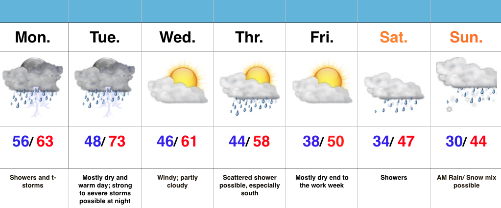
- Rainy open to the week
- Severe storms possible Tuesday night
- Active pattern continues this week
Rainy Monday; Severe Storms Possible Tuesday…A disturbance is helping push showers and thunderstorms north into central IN to open the work week. Most of the rain and embedded thunderstorms will fall during the morning into the afternoon hours before drier air works in here tonight. That will set us up for a mostly dry, breezy, and warm Tuesday, but all attention will be on Tuesday night. We still think thunderstorms that ignite in IL Tuesday afternoon will race eastward and impact Indiana Tuesday night. More specifically, we’re bracketing the hours of 8p-2a for severe prospects locally. All modes of severe weather are in play, particularly damaging winds and hail. Stay tuned.
As we progress into the second half of the week, things remain rather busy. A couple weak disturbances could offer up Thursday showers (especially south). The evolution of things this weekend is still very much up in the air, but for now we’ll go with increasing clouds Saturday giving way to showers. As colder air gets involved with this storm system, precipitation may mix or end as wet snow Sunday.
7-Day Precipitation Forecast:
- Snowfall: Trace
- Rainfall: 1.25″ – 1.75″ (locally heavier totals)
Interested in more in-depth long range forecast discussions, video updates, ag. forecasts, and seasonal outlooks? E-mail bill@indywx.com for more information.
Permanent link to this article: https://indywx.com/rainy-monday-severe-weather-possible-tuesday-night/


