Category: 7-Day Outlook

Thursday Morning Weather Notebook…

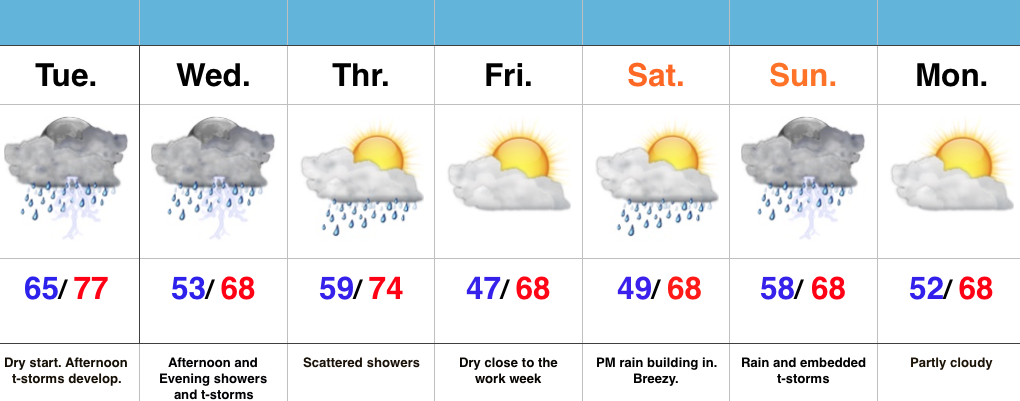
Noisy thunderstorms (non-severe) are impacting southern ‘burbs this morning, but dry time is coming as we get into the heart of the rush hour.  This dry time will continue into the late morning hours, but renewed showers and thunder will likely fire yet again early this afternoon (in scattered fashion).

2After an unsettled few days, we’ll get a break, albeit brief, from the wet, stormy times to close the work week.  High pressure will present an increasingly sunny sky Friday, but it’ll be much cooler than today (mid 60s for highs Friday).

4As mentioned, dry times won’t last long.  Rain builds back in Saturday and lingers into Sunday.  Locally heavy rain is possible, including embedded thunderstorms.  Early rain numbers fall in the 1″-1.5″ range over the weekend.

3
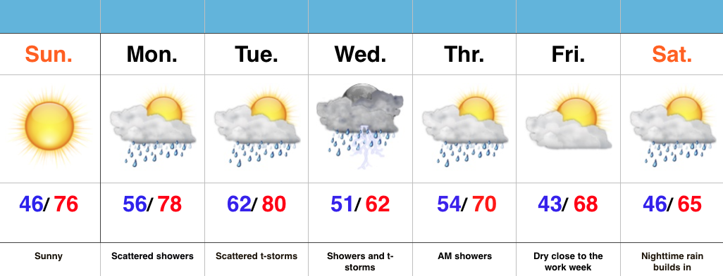
As we open May, attention turns to a much cooler than normal feel of things.  In fact, overnight data is particularly bullish on the chill next Thursday morning (suggests mid 30s).

1

Permanent link to this article: https://indywx.com/thursday-morning-weather-notebook/

Thunderstorms Fire This Afternoon…

Screen Shot 2016-04-26 at 7.57.17 AMHighlights:

  • T-storms develop this afternoon
  • Another round of showers and t-storms push in Wednesday afternoon/ evening
  • Briefly drier Friday
  • New storm delivers a wet weekend

Turning Noisy This Afternoon…It’s a relatively quiet start to the day across central IN, but a cold front will help ignite rather robust shower and thunderstorm development as early as the lunchtime hour.  Storms will grow in intensity and coverage as we progress through the afternoon and evening, especially along I-70 and points south.  Locally heavy rain will be likely.  Stronger storms will be capable of producing hail and damaging winds.

Another round of showers and thunderstorms are on deck Wednesday afternoon and evening.  When all is said and done by Thursday morning, widespread rain totals of 1″ to 1.5″ will be a good bet, with locally heavier amounts.

Friday will feature a beautiful close to the work week with drier air working in and some sunshine.  That said, the sunny skies won’t last as showers and thunderstorms return over the weekend.

Permanent link to this article: https://indywx.com/thunderstorms-fire-this-afternoon/

Bumpy Ride This Week…

Screen Shot 2016-04-25 at 12.57.17 PMHighlights:

  • Lots of sun through the daytime
  • Storms rumble in late tonight
  • Unsettled mid week pattern
  • New storm delivers rain and wind this weekend

Beautiful Today; Storms Arrive Late Tonight…We couldn’t ask for better weather through the daytime today (despite a gusty SW wind), but chances for rather noisy thunderstorms increase late tonight into the predawn hours Tuesday.  Unsettled conditions remain Tuesday, including scattered thunderstorms especially across the I-70 corridor and points south.  Locally hefty downpours will be possible.

More widespread showers and embedded thunder are on tap Wednesday into Thursday, especially through the morning hours Thursday.  Widespread 1″-1.5″ rain totals are a good bet between now and Thursday morning, with some locally heavier amounts.

We still think we get a briefly drier air mass in here to close the work week, but this won’t last long.  Our next storm system is dialed up for a weekend arrival and will provide a stiff easterly breeze and rain Saturday PM through Sunday.

Permanent link to this article: https://indywx.com/bumpy-ride-this-week/

Beauty Of A Sunday…

Screen Shot 2016-04-24 at 11.14.16 AMHighlights:

  • Sunny close to the weekend
  • Warm and increasingly humid early week with showers
  • Widespread rain and storms Wednesday
  • Significant rain maker to open May

Good Supply Of Vitamin D…High pressure will remain in control of our weather today and supply mostly sunny skies and warm temperatures.  Get outside and enjoy!

Moisture will begin to increase as we progress through the early portions of the work week with showers and scattered thunderstorms developing Monday into Tuesday.  We’ll still enjoy lots of dry time in between the scattered showers.

More widespread showers and thunderstorms will push into the state Wednesday.  Early numbers suggest amounts of 0.75″-1″.  Lingering showers remain Thursday morning, but we should get a nice push of dry air in here Thursday afternoon into Friday.

Attention will then shift to a significant system that promises to provide heavy rain and embedded thunderstorms as early as Saturday night.  We still have time to watch this, but from this distance it appears as if this will be a “juicy” storm system.  We’re also eyeing a much cooler open to May…

Permanent link to this article: https://indywx.com/beauty-of-a-sunday/

Saturday Morning Rambles…

April is running nearly 6° below average and nearly spot-on where we should be from a precipitation perspective through the 15th.       As we move forward, the big story…

You must be logged in to view this content. Click Here to become a member of IndyWX.com for full access.  Already a member of IndyWx.com All-Access?  Log-in here.

Permanent link to this article: https://indywx.com/saturday-morning-rambles-8/