 Highlights:
- Arctic air blows in tonight
- Winter storm potential this weekend
- Another blast of arctic air next week
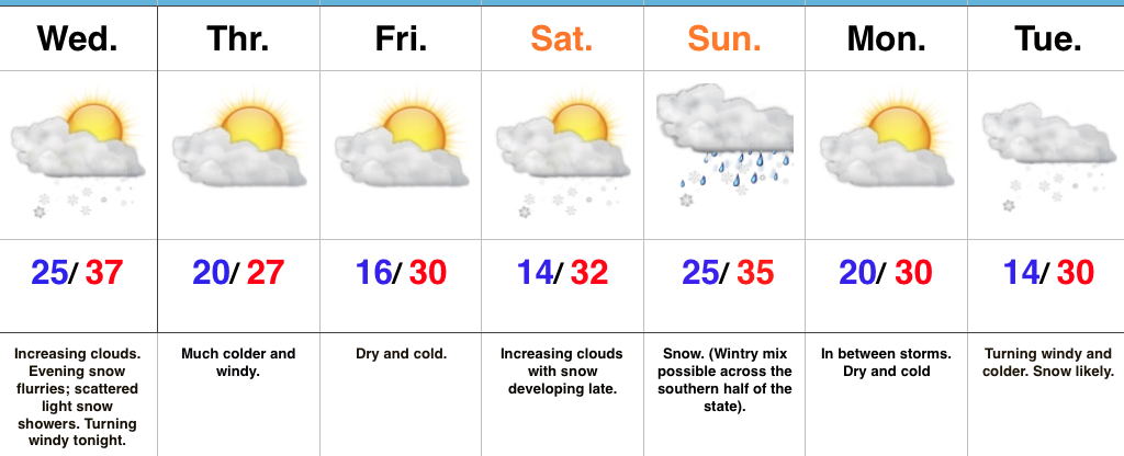
Busy Times Ahead…The fun and active winter pattern has arrived and will keep us forecasters on our toes as we go through the next couple weeks. Early sunshine will give way to an increasingly cloudy sky this afternoon and a couple snow flurries or scattered light snow showers may precede the arctic plunge this evening. Snow lovers, unfortunately the arctic wave didn’t materialize as we once thought. (Hang in there, you have many more snow opportunities ahead). We’ll turn windy tonight and wind chills will fall into the single digits by Thursday morning. We’ll stay dry, but cold to wrap up the work week.
Eyes will then shift to the weekend as a developing storm system pushes snow into the region Saturday night. Snow and/ or a wintry mix will continue Sunday. Where this remains all snow, it’s likely to be a “plowable” event. We still need to fine tune the details over the next couple of days to hone in on just where the mixing line will set up. Thinking now is that from Indianapolis and points north, this is mostly a snow event, but stay tuned.
Another round of snow and wind will blow into town early next week. This will likely be ahead of an even colder push of air by the middle part of next week.
Upcoming 7-Day Precipitation Forecast:
- Snowfall: 3″ – 5″
- Rainfall: 0.10″ – 0.25″
