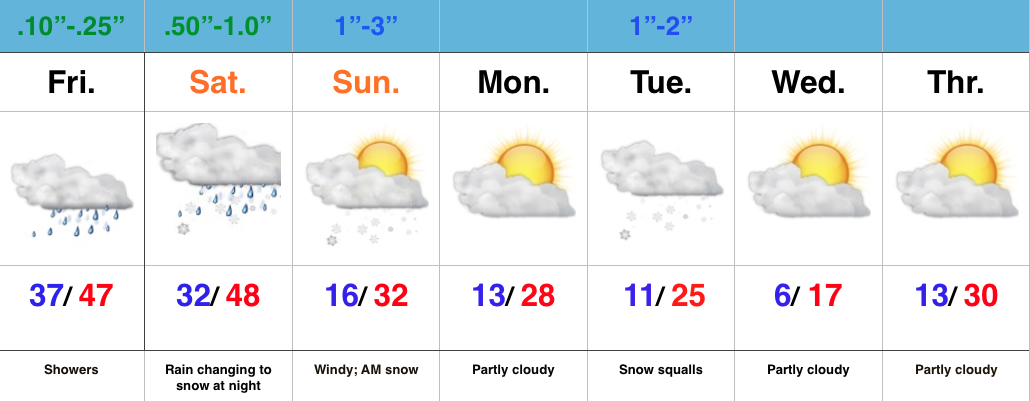
- Wet close to the week
- Rain to snow Saturday night into early Sunday
- One-two punch of arctic air
- Snow squalls Tuesday
Wet Close To The Week; Winter Blows In To Town…The region will deal with two storm systems as we go through the next few days. Today’s area of low pressure will be responsible for pushing rain showers through the state and while it won’t rain the entire day, it’ll be wise to keep the rain gear nearby.
A secondary area of low pressure will lift northeast Saturday into Saturday night. Heavier rains will arrive into central IN Saturday afternoon and the precise track of this second area of low pressure is key in determining the transition from rain to snow as cold air arrives on the scene. As of now, we’ll focus on a changeover overnight Saturday night/ Sunday morning. Initial thinking paints a 1″-3″ swath across central IN, but before issuing our first snowfall map, we want to have an opportunity to see the complete 12z model suite.
Regardless of how much snow falls Sunday morning, expect a much colder feel and strong and gusty winds as we go through the second half of the weekend. Arctic reinforcements arrive Tuesday and we’ll know it. Expect snow squalls and bitterly cold air for mid week.
Looking ahead, busy times continue down the road. An early look at next weekend shows a pattern plenty capable for renewed wintry “fun and games…”

