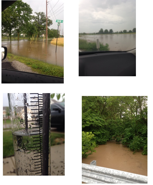
A rather rare flood event took place across localized areas of central Indiana between Wednesday, June 18th, 2014 and Thursday, June 19th, 2014. (27) hour rainfall totals 4pm Wednesday, June 18th through 7pm Thursday, June 19th reached 5.5″ (5) miles northwest of Zionsville, IN in southeastern Boone County, IN. 2.9″ of that rain fell in less than a (3) hour period between 4pm and 7pm Thursday, June 19th.
Local Agriculture impact:
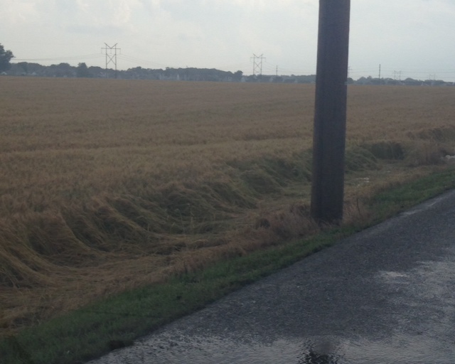
Numerous central and southern Boone County crops experienced some sort of damage from rapid run off of the torrential rainfall. Communities and farmland impacted included Lebanon, Whitestown, and Zionsville.
Ground-truth reports taken at our IndyWx.com headquarters (5 miles northwest of Zionsville, just outside Whitestown, IN) recorded 5.5″ of rain within the (27) hour period mentioned above.
Radar estimated data also shows the widespread 4-5″+ rainfall totals across Boone County over the past 24 hours- Wednesday, June 18th through Thursday, June 19th.
Forecast model data from as early as Thursday morning suggested that particular afternoon and evening could feature training of heavy rain producing thunderstorms through central Indiana, including some embedded strong to severe thunderstorms, despite the Storm Prediction Center including central Indiana in any sort of severe weather categorical outlook (Slight Risk, or above). That said, it should also be noted that this wasn’t a major severe weather outbreak across central Indiana, though isolated severe weather reports did come in, including a brief tornado touchdown near Anderson Thursday afternoon, along with a couple of additional severe thunderstorm warnings. That said, the purpose of this post will focus on the set-up for heavy, and in some cases excessive, rainfall “training” (moving repeatedly over the same locale) over central Indiana communities Thursday afternoon/ evening.
First, let’s take a look at the broad scale pattern set-up. Needless to say, it’s certainly easy to see why localized flash flooding developed.
Thursday morning’s 06z model runs suggested CAPE values, or Convective Available Potential Energy, would reach 4800-5000 across central Indiana. You can look at CAPE as the “umph,” or fuel, that basically will feed a thunderstorms it’s energy. Anything over 2000 is considered plenty enough for strong thunderstorm potential.
 The overall upper air pattern and steering currents suggested portions of the Ohio Valley would be under the gun, so to speak, for potential training of heavy rain and associated thunderstorms.
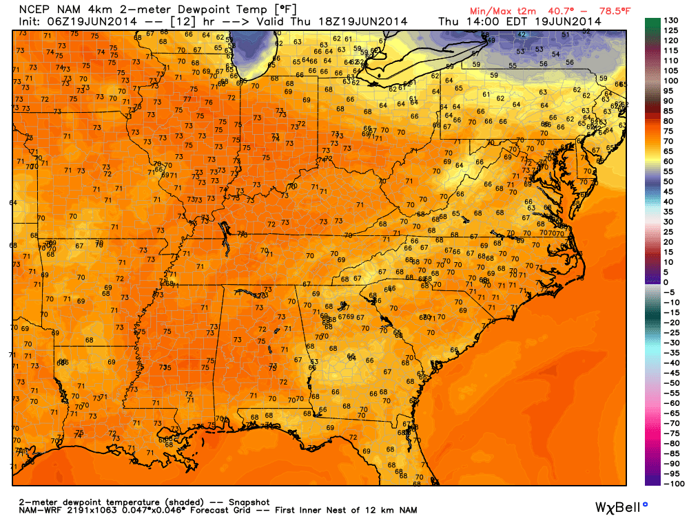
Rich tropical moisture was readily available across the area, indicative of 06z forecast dew points in the upper 60s and lower 70s across the Ohio Valley region.
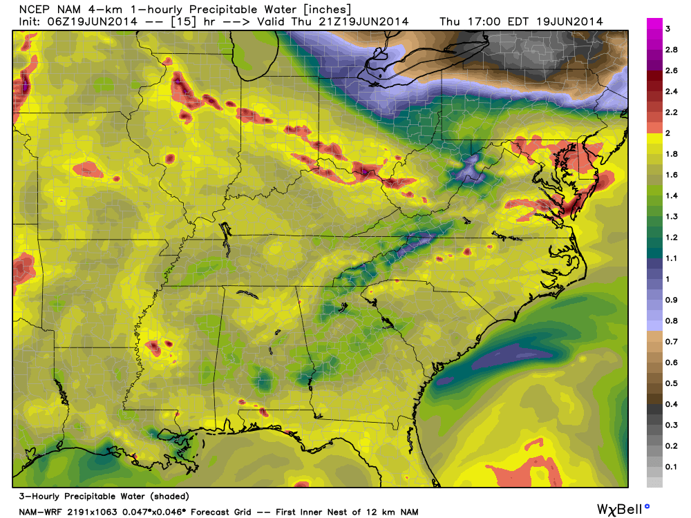
Perhaps the more telling story had to do with the forecast PWAT, or Precipitable Water, values that exceeded 2″ to 2.4″ across portions of central Indiana from the 06z model run Thursday morning. PWAT values are a good indication of heavy rainfall potential should there be something to trigger (lifting mechanism) showers and storms. PWAT values of 2″ and above are considered extreme and rather rare, even for this time of year.
We tip our hat to the 06z 4km NAM picking up on this early Thursday morning as it very closely matched where training thunderstorms and heavy rain initiated Thursday afternoon. Take a look at the forecast PWAT levels and the afternoon radar on Thursday, June 19th, as storms began to develop: Note rainfall rates exceeded 2″/ hr. across portions of central Indiana, including Boone County on the afternoon of June 19th.
Compare that to the forecast radar from another one of our short-term, high resolution, forecast models, the HRRR, valid 6pm:
(We want to thank the fine folks at Weatherbell Analytics for some of the forecast model images. Additionally, thanks to Radarscope for the radar storm rainfall totals).
In closing, a combination of ingredients came together to present a localized, yet very significant flood event, for central Indiana. The upper air pattern promoted movement of abnormally moist air to stream north into the Ohio Valley region. At the same time, the same pattern resulted in a steering current that was relatively weak across our immediate region- adding to the potential of training. The storms actually initiated (formed) along an old outflow boundary from the previous night, Wednesday, June 18th/ early morning Thursday, June 19th.
The days ahead will continue the unsettled theme across the region and we’ll have to remain on our toes for potential additional significant weather impacts as we move forward Friday, and even into the weekend. Much more later.


1 comment
Bill,
I wanted to comment on this evening a little further in depth than tweets will allow. To preface the detail, I work in downtown Indy (to pay the mortgage) and I take the scenic route to and from work.
– As I left the office at 5:00 Thursday evening, I checked the radar and noted storms around Lafayette. I figured I had enough time to get home and complete the chores before the storms made it to the farm. There were no storms in the Indy metro area.
– Exiting I-65 at 71st Street at approx. 5:15, I noted dark clouds closer than I expected and figured the storms were popping more quickly than I had hoped.
– Waiting to cross Oak Street (old 334) at Kissel Road at approx. 5:25, it started to sprinkle.
– Less than one mile later, I had to slow down due to the intensity of the rain.
– Within the next three miles, I drove through four separate areas where the road was flooded.
-By the time I reached home at approx. 5:45, our rain gauge already read slightly over 2″. All told from that storm, we had 3.1″ in leases than two hours.
Farmer Paul