Thoughts Shift Towards Severe Weather Season…

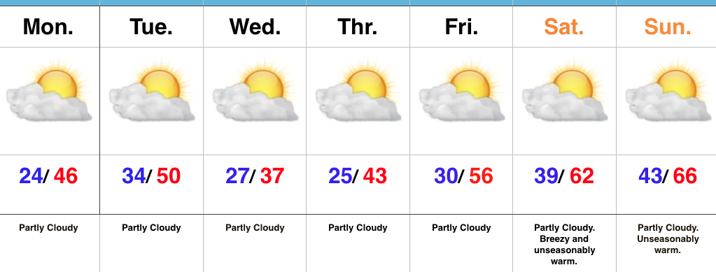
With the unseasonable warmth this week, our thoughts begin to shift to the coming spring months ahead.  Of course with spring comes the potential of storms- some of which include severe weather outbreaks.

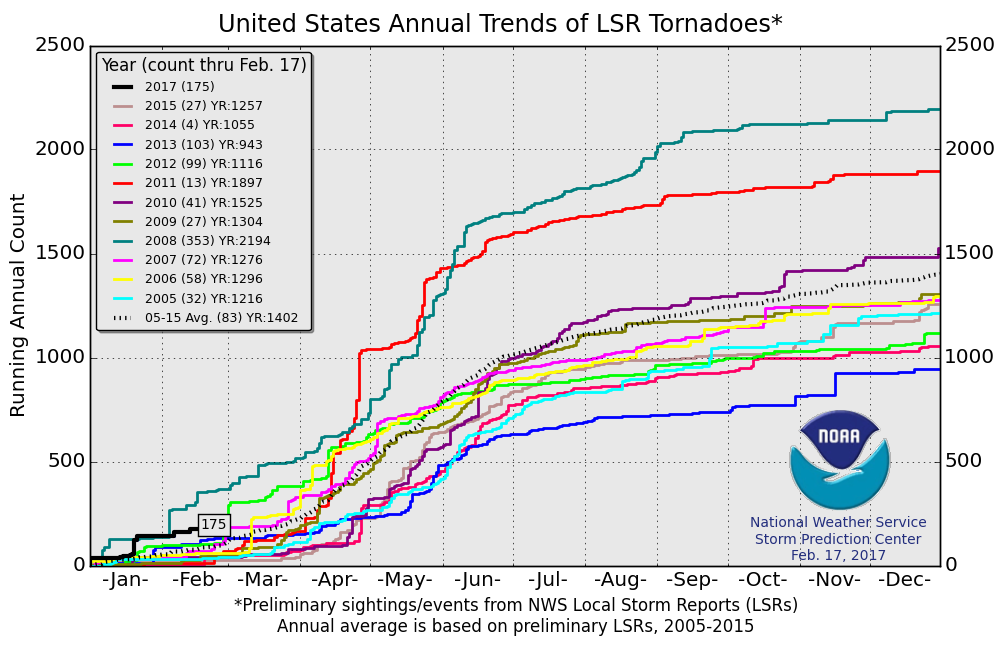
Already, 2017 has wasted no time in the tornado department, year-to-date- more than double the (10) year average across the United States.
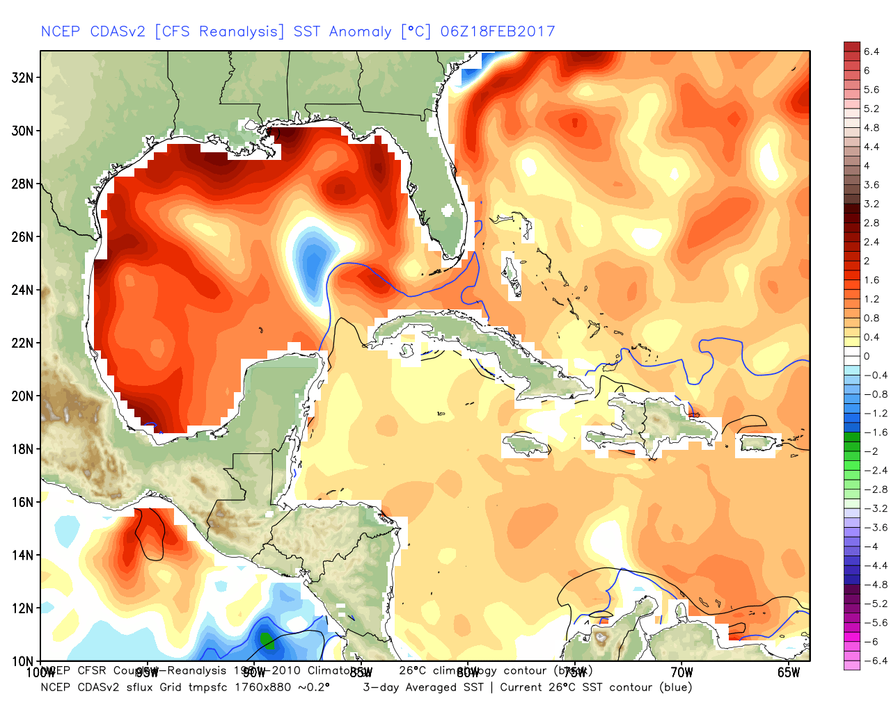
The Gulf of Mexico is boiling warm (running 1°-3° C above normal) and this will aid in transporting moisture-rich air north.  As storms eject out of the Rockies and Plains, one would tend to believe anomalously warm dew points and precipitable water values will be available.
The JMA Weeklies show an active stretch developing as we progress through the next few weeks.
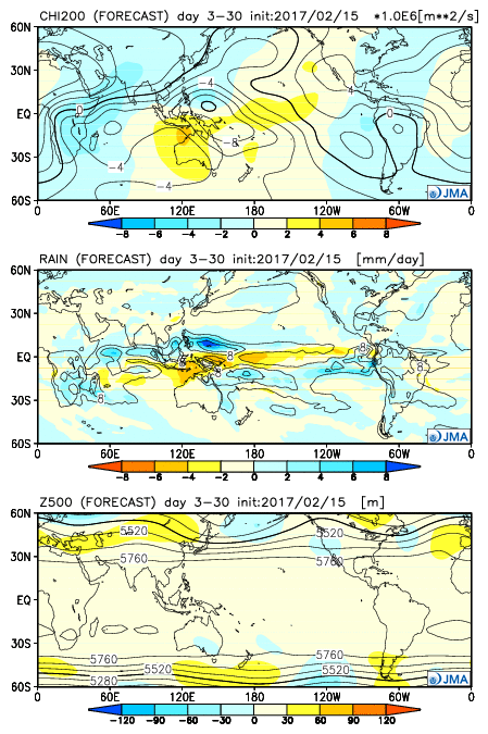
As we rumble deeper into the spring months, the mean trough position should be located across the west.  The end result should be a mean storm track that runs into the Ohio Valley- courtesy of resistance from an eastern ridge (that warm water in the Gulf and East Coast screams the mean ridge position should be located across the east coast).  Confidence is greater than normal on a busy severe weather season.

Much more later as spring evolves.

Extended Dry Period; Spring-Like Weekend Ahead…

Highlights:

  • Chilly today
  • Spring-like weekend
  • Extended dry period

Beautiful Weather…There’s no reason to waste many pixels on this forecast.  Despite a slight “speed bump” today (temperatures will top out a few degrees below normal), the balance of this 7-day forecast period is one that will feature unseasonably pleasant (and quiet) weather.  We’ll note periods of clouds today as weak cold air advection kicks in, along with a gusty northerly breeze this afternoon.

After Thursday morning, it’s off to the races as an extended period of sunshine will be with us as we wrap up the work week and head into the weekend.  Temperatures will reach 60 Friday, mid/ upper 60s this weekend, and near 70 Monday.

The next weather item of note will be increasing clouds late Tuesday, followed by showers Wednesday.

Upcoming 7-Day Precipitation Forecast:

  • Snowfall: 0.00″
  • Rainfall: 0.00″

Uneventful Weather; Warming Up Late Week…

Highlights:

  • Dry weather this week
  • Briefly cooler mid week
  • Weekend warm-up

Sunglasses Required…We’re opening the work week with crystal clear blue skies and cold temperatures. Mostly sunny conditions will give way to increasing high level cloudiness this afternoon/ evening as a storm system passes by to our south.  That increase in cloudiness is about as “exciting” as it gets this week in the weather department.  Reinforcing chilly conditions will dive south into the region Tuesday night into Wednesday, but we’ll remain precipitation-free.

Like so many other cold blasts this winter, the chill won’t have staying power and we’ll get back to a moderating trend heading into the weekend.  Many places will likely come close to 70° by the second half of the weekend as dry conditions remain. Enjoy friends!

Upcoming 7-Day Precipitation Forecast:

  • Snowfall: 0.00″
  • Rainfall: 0.00″