Author's posts

VIDEO: Chilly Pattern Locks In; Talking Precipitation Chances In The Week Ahead…

Updated 04.22.23 @ 7:50a

You must be logged in to view this content. Click Here to become a member of IndyWX.com for full access.  Already a member of IndyWx.com All-Access?  Log-in here.

Permanent link to this article: https://indywx.com/2023/04/22/video-chilly-pattern-locks-in-talking-precipitation-chances-in-the-week-ahead/

Long Range Update: Looking In More Detail At May…

Updated 04.21.23 @ 7:56a

You must be logged in to view this content. Click Here to become a member of IndyWX.com for full access.  Already a member of IndyWx.com All-Access?  Log-in here.

Permanent link to this article: https://indywx.com/2023/04/21/long-range-update-looking-in-more-detail-at-may/

VIDEO: Timing Out Rain And Storms To Close The Week; Chilly Pattern To Close Out April…

Updated 04.20.23 @ 8:04a

You must be logged in to view this content. Click Here to become a member of IndyWX.com for full access.  Already a member of IndyWx.com All-Access?  Log-in here.

Permanent link to this article: https://indywx.com/2023/04/20/video-timing-out-rain-and-storms-to-close-the-week-chilly-pattern-to-close-out-april/

VIDEO: Tracking 2 Rounds Of More Widespread Rain Heading Into The Weekend…

Updated 04.19.23 @ 7:49a

You must be logged in to view this content. Click Here to become a member of IndyWX.com for full access.  Already a member of IndyWx.com All-Access?  Log-in here.

Permanent link to this article: https://indywx.com/2023/04/19/video-tracking-2-rounds-of-more-widespread-rain-heading-into-the-weekend/

Note On Late Week…

Updated 04.18.23 @ 7:15p

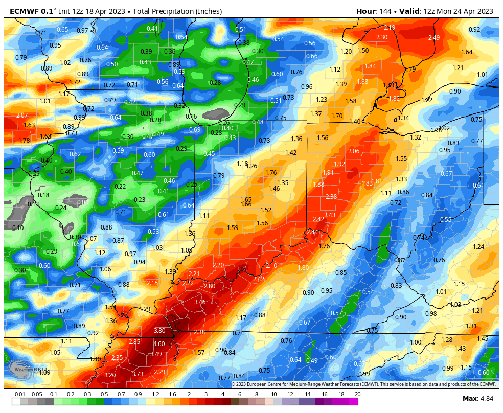
Today’s guidance is starting to hone in on the most likely scenario as we close out the work week and head into the weekend. After a couple days of what sure seemed like “far fetched” solutions being printed out by the GFS, it’s trended much closer towards what the European was showing this morning. The model is actually more like a “blend” of the two ideas from this morning.

We continue to believe the initial wave of moisture will arrive Thursday evening (after a very warm and dry day). This will then be followed by a second surge of moisture Friday night into Saturday morning (lasting into Saturday afternoon across eastern Indiana). This second wave of precipitation will likely be more widespread and heavier for the eastern half of the state during the aforementioned time frame. As colder air gets pulled into the region, wrap-around precipitation will mix with wet snow (yet again) Saturday night into Sunday morning. High pressure should then build overhead allowing for the coldest air to settle in Sunday night and Monday morning (potentially with a repeat Tuesday morning depending on the timing of our next system). If skies clear as anticipated, the potential remains for overnight lows to dip into the upper 20s.

As mentioned above, forecast models are now in much better agreement regarding rainfall placement and amounts (heaviest across central and eastern IN) with this event.

We’ll see if these trends hold firm overnight and be sure to cover this (and more) in our Client video discussion Wednesday morning!

Make it a relaxing evening!

Permanent link to this article: https://indywx.com/2023/04/18/note-on-late-week/

VIDEO: Brief Warm-Up On The Way; Unsettled Close To The Week And A Cooler Than Normal Close To April/ Open To May…

Updated 04.18.23 @ 7:33a

You must be logged in to view this content. Click Here to become a member of IndyWX.com for full access.  Already a member of IndyWx.com All-Access?  Log-in here.

Permanent link to this article: https://indywx.com/2023/04/18/video-brief-warm-up-on-the-way-unsettled-close-to-the-week-and-a-cooler-than-normal-close-to-april-open-to-may/

VIDEO: Ugly Open To The Work Week Ahead Of A Brief Spike In Temperatures; More Pleasant Weather. Hard Freeze Threat Early Next Week…

Updated 04.17.23 @ 7:45a

You must be logged in to view this content. Click Here to become a member of IndyWX.com for full access.  Already a member of IndyWx.com All-Access?  Log-in here.

Permanent link to this article: https://indywx.com/2023/04/17/video-ugly-open-to-the-work-week-ahead-of-a-brief-spike-in-temperatures-more-pleasant-weather-hard-freeze-threat-early-next-week/

VIDEO: Rain Changes To Snow To Open Up The Week; Hard Freeze Threat On The Table Early Next Week…

Updated 04.16.23 @ 8:01a

You must be logged in to view this content. Click Here to become a member of IndyWX.com for full access.  Already a member of IndyWx.com All-Access?  Log-in here.

Permanent link to this article: https://indywx.com/2023/04/16/video-rain-changes-to-snow-to-open-up-the-week-hard-freeze-threat-on-the-table-early-next-week/

VIDEO: Gorgeous Saturday Ahead Of An Unsettled Open To The New Week; Chilly Close To April On Deck…

Updated 04.15.23 @ 8:56a

You must be logged in to view this content. Click Here to become a member of IndyWX.com for full access.  Already a member of IndyWx.com All-Access?  Log-in here.

Permanent link to this article: https://indywx.com/2023/04/15/video-gorgeous-saturday-ahead-of-an-unsettled-open-to-the-new-week-chilly-close-to-april-on-deck/

VIDEO: Half And Half Weekend; Couple Systems To Track Next Week…

Updated 04.14.23 @ 7:55a

You must be logged in to view this content. Click Here to become a member of IndyWX.com for full access.  Already a member of IndyWx.com All-Access?  Log-in here.

Permanent link to this article: https://indywx.com/2023/04/14/video-half-and-half-weekend-couple-systems-to-track-next-week/

IndyWx.com