Author's posts

VIDEO: To Quote Bob Dylan, “Times, They Are A Changin…”

Updated 11.13.21 @ 7:22a

You must be logged in to view this content. Click Here to become a member of IndyWX.com for full access.  Already a member of IndyWx.com All-Access?  Log-in here.

Permanent link to this article: https://indywx.com/2021/11/13/video-to-quote-bob-dylan-times-they-are-a-changin/

VIDEO: The First Flakes Of The Season…

Updated 11.12.21 @ 6:45a

You must be logged in to view this content. Click Here to become a member of IndyWX.com for full access.  Already a member of IndyWx.com All-Access?  Log-in here.

Permanent link to this article: https://indywx.com/2021/11/12/video-the-first-flakes-of-the-season/

A Step In The Right Direction, But Persistent Cold Pattern Still A Ways Off…

Updated 11.11.21 @ 6:55a

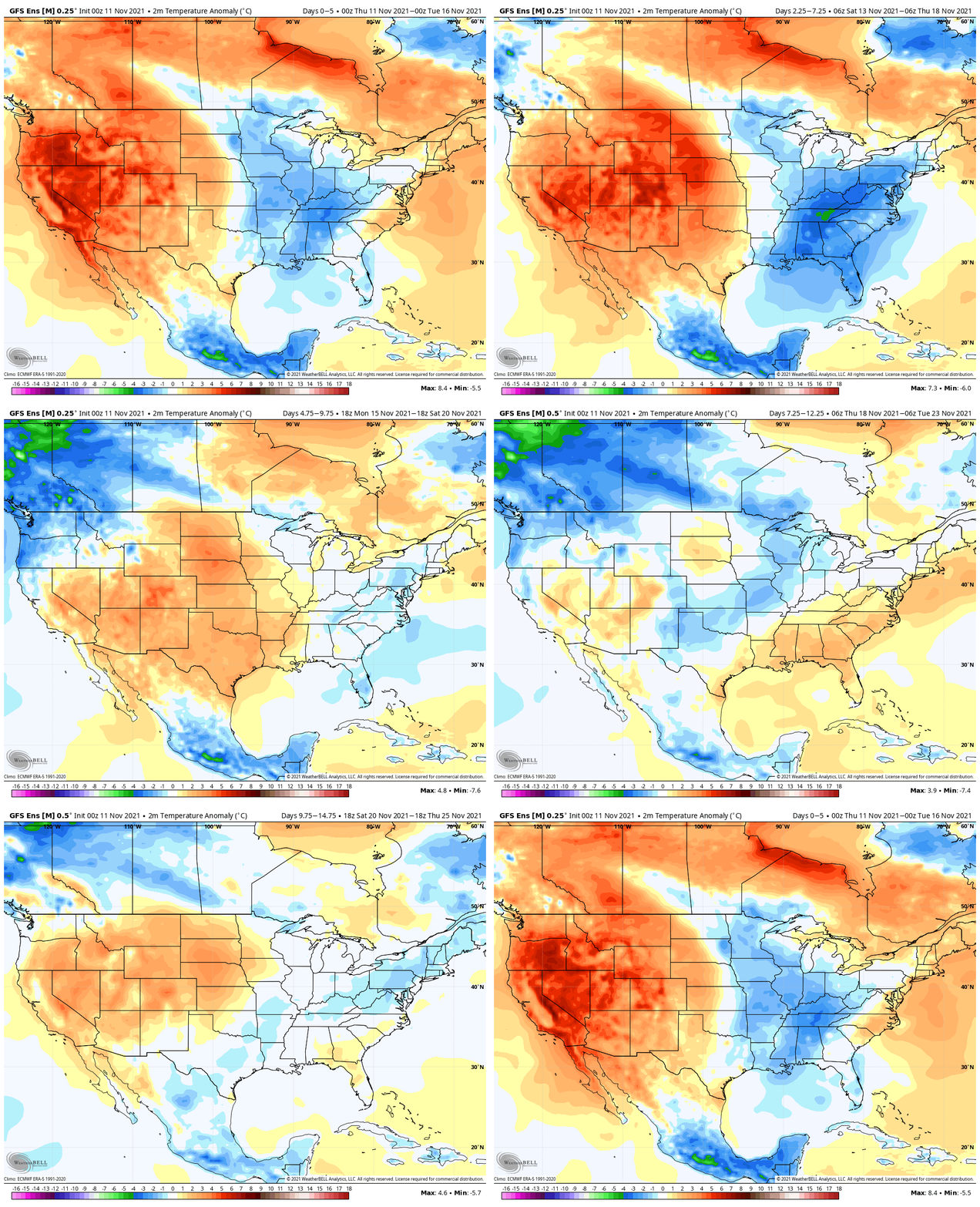
The long running idea here (since summer) has been one that has thought a rather sharp and significant colder pattern would emerge around Thanksgiving to help kick-start a fast start to meteorological winter. Guidance shows a couple of chilly air masses poised to settle into the region over the upcoming couple of weeks.

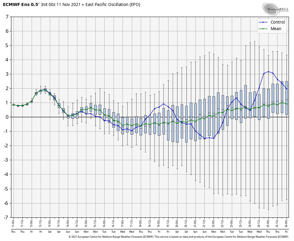
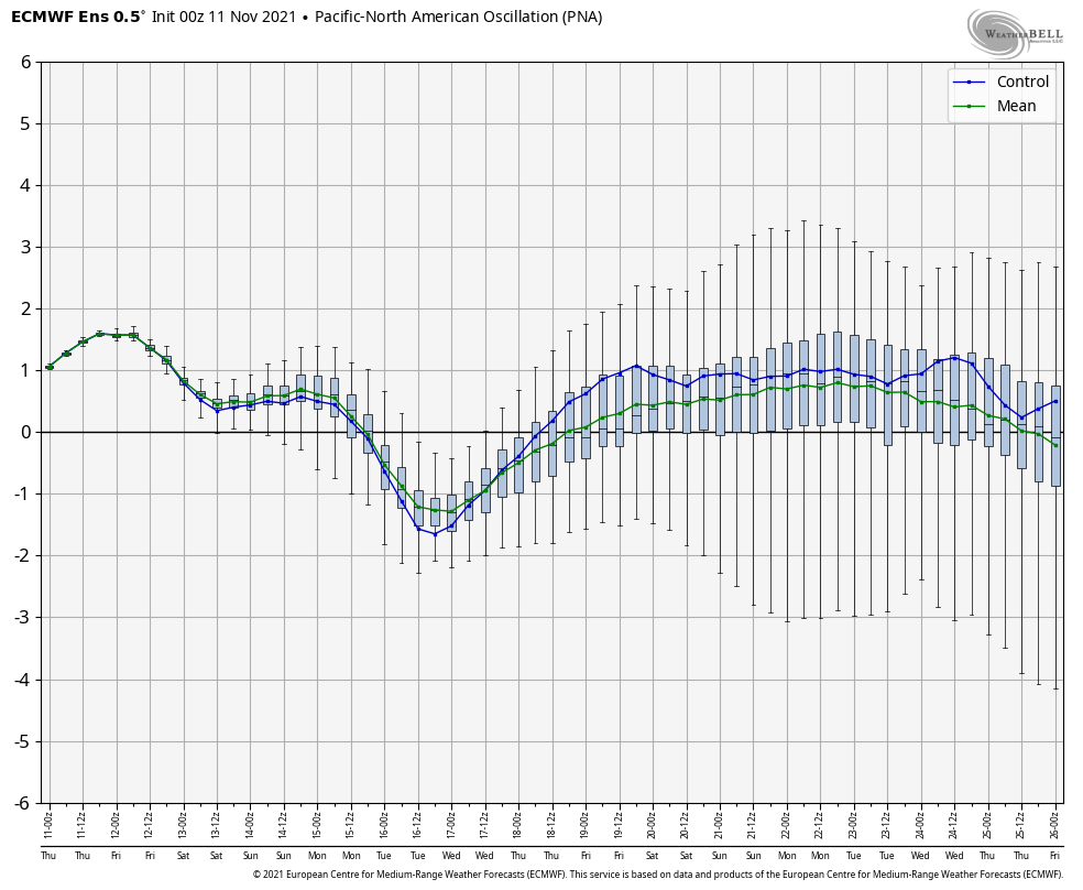
The coldest air of the season so far (lower 20s) awaits next week, but notice that guidance takes a transient approach with these colder shots. That’s for good reason when you look at the teleconnections. We’re still waiting on the PNA and EPO (MJO remains off the playing field- for now) to align in a manner that will drive a persistent cold pattern, but over the next couple of weeks, it doesn’t appear this will be the case. For those wanting a persistent cold pattern, you want to root for a positive PNA to compliment a negative EPO.

Rest assured the idea here isn’t changing regarding the fast and cold start to meteorological winter, but we’re rapidly approaching the period where this idea will be put to test. If by Thanksgiving week we still don’t see the movement expected with the EPO and PNA then it’ll be time to look for a Plan B.

One additional element with this is that we believe the MJO will become a driver in the expected cold start to the season (a byproduct of the sea surface temperature configuration and 2nd year Nina). It’ll be interesting to see if we can get the MJO out of the neutral phase and into position to make an impact driving an expected more persistent cold regime.

Potential is high in this setup. Now it’s time to simply sit back, wait, and watch for the hours of research back in the summer to either come to fruition or flop. 😃

Permanent link to this article: https://indywx.com/2021/11/11/a-step-in-the-right-direction-but-persistent-cold-pattern-still-a-ways-off/

VIDEO: Cold Front Whips Across The State Thursday…

Updated 11.10.21 @ 6:47a

You must be logged in to view this content. Click Here to become a member of IndyWX.com for full access.  Already a member of IndyWx.com All-Access?  Log-in here.

Permanent link to this article: https://indywx.com/2021/11/10/video-cold-front-whips-across-the-state-thursday/

VIDEO: Changeable Late Week Weather; Weekend Snow Maker For Some Across The Region?

Updated 11.09.21 @ 7:22a

You must be logged in to view this content. Click Here to become a member of IndyWX.com for full access.  Already a member of IndyWx.com All-Access?  Log-in here.

Permanent link to this article: https://indywx.com/2021/11/09/video-changeable-late-week-weather-weekend-snow-maker-for-some-across-the-region/

VIDEO: Beautiful Open To The Work Week Before An Unsettled, Colder Finish…

Updated 11.08.21 @ 6:55a

You must be logged in to view this content. Click Here to become a member of IndyWX.com for full access.  Already a member of IndyWx.com All-Access?  Log-in here.

Permanent link to this article: https://indywx.com/2021/11/08/video-beautiful-open-to-the-work-week-before-an-unsettled-colder-finish/

Stretch Of Pleasant Conditions Before A Change…

Updated 11.07.21 @ 7:51a

We’re opening up the new week with glorious early-November conditions. High pressure will remain in firm control of our pattern, supplying plentiful sunshine. A shift in our wind direction to the southwest will help drive a big boost in temperatures into the middle part of the upcoming week.

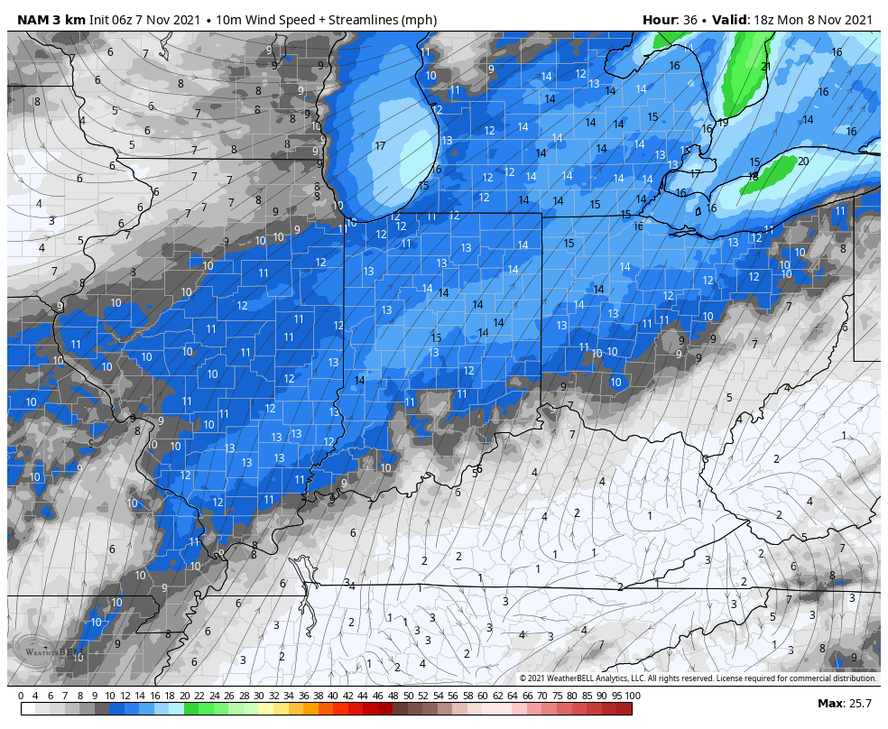
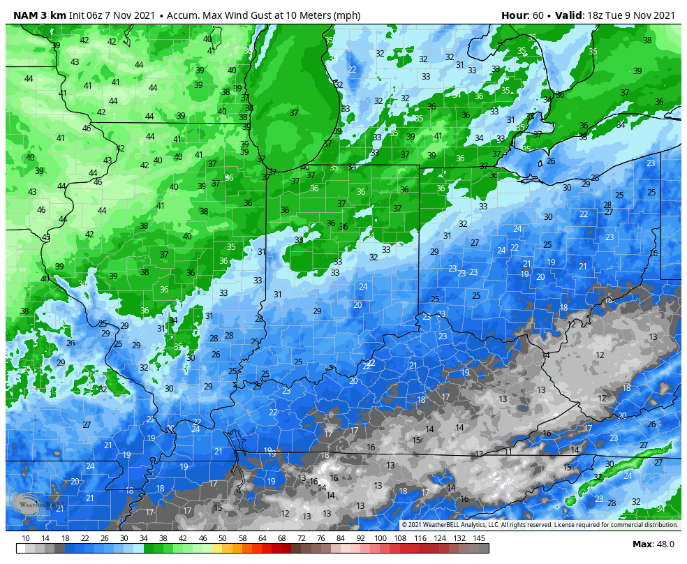
At times, these southwest winds will gust more than 30 MPH Monday afternoon.

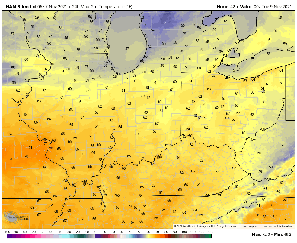
This will help boost high temperatures into the lower and middle 60s today through Wednesday. Get out there and enjoy the unseasonably mild conditions!

Changes are on deck as we move into the middle of the week thanks to an approaching cold front. Clouds will increase and we could have a couple of light showers sneak in here Wednesday before more widespread showers arrive Thursday with the frontal passage, itself. Plan on another day of big wind gusts Thursday (40+ MPH) as the front sweeps through.

As of now we expect rainfall amounts to check-in between 0.25″ and 0.75″ with the passage of Thursday’s front.

We’ll keep close eyes on “wrap-around” moisture Thursday night and Friday. With colder air in place at this point, the first snowflakes of the season appear likely for several of our neighbors across northern Indiana.

The coldest air so far this fall season will arrive next weekend.

Permanent link to this article: https://indywx.com/2021/11/07/stretch-of-pleasant-conditions-before-a-change/

VIDEO: Temperatures Moderate And We Remain Dry Into Midweek; Pattern Change Dialed Up By Mid Month…

Updated 11.06.21 @ 8a

You must be logged in to view this content. Click Here to become a member of IndyWX.com for full access.  Already a member of IndyWx.com All-Access?  Log-in here.

Permanent link to this article: https://indywx.com/2021/11/06/video-temperatures-moderate-and-we-remain-dry-into-midweek-pattern-change-dialed-up-by-mid-month/

VIDEO: Moderating Trend Gets Underway Ahead Of A Deep Trough Late Next Week; Winter Outlook Recap…

Updated 11.05.21 @ 7:45a

You must be logged in to view this content. Click Here to become a member of IndyWX.com for full access.  Already a member of IndyWx.com All-Access?  Log-in here.

Permanent link to this article: https://indywx.com/2021/11/05/video-moderating-trend-gets-underway-ahead-of-a-deep-trough-late-next-week-winter-outlook-recap/

2021-2022 IndyWx.com Winter Outlook…

Updated 11.03.21 @ 9:50p

Quick-Hitter Highlights of the ’21-’22 Winter season:

I. Expecting a fast, cold, and wintry start to the season.

II. Active times continue, but expecting a pull back in the cold mid and late winter.

III. Overall, expecting a slightly warmer than normal winter, locally.

IV. Forecasting 20″ of snow at IND this winter (first flake to last flake- average is 25.5″).

A weak La Nina is expected to dominate headlines, globally, this winter. We know no Nina, Nino, or La Nada event is going to behave identical but we can look back at the archives and pull together analogs to perhaps get some sort of indication of what the coming months will dish up!

In short, we expect an active storm track through the Ohio Valley and upper Mid West this winter. A “typical” La Nina pattern (remember the disclaimer above, however) features a wet and cold Northwest with an active jet stream pushing frequent storm systems through the Ohio Valley and interior Northeast. Many times, the aforementioned jet stream pattern can lead to an unseasonably warm and dry south-central into the Southeast- overall.

There are certain wild cards that can create headaches in any winter, including the NAO, AO, MJO activity, and Pacific patterns (namely, PNA and EPO).

In our research looking back at La Nada and weak Nina events, there’s a clear tendency for fast starting winters. We’ve been sharing this idea through the summer months and continue to believe a rather significant and perhaps dramatic shift towards cold, wintry conditions looms to wrap up November and head into December.

Getting right to the point, we lean towards December featuring average temperatures that range close to 3° below normal and features above average snowfall of 7″ to 10″ across most central Indiana reporting sites, including IND (where the Dec. average is 6.4″).

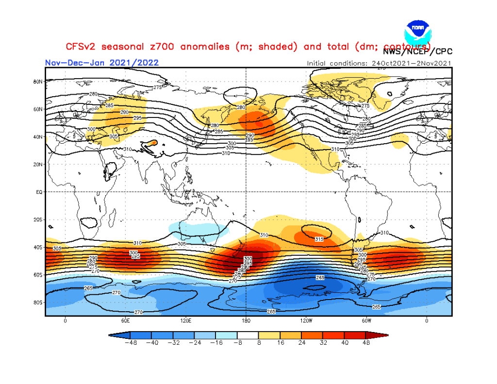
The way the CFSv2 seasonal handles the evolution in the upper levels over the course of the late fall into early spring makes sense to us.

Note how the trough begins to pull back into the West towards mid and late winter. While the active storm track will likely continue to keep us on the playing field for the “perfect marriage of moisture and cold,” the overall pattern should lead to more of a wet/ warm/ mixing issue as compared to cold being able to maturely lock-in to provide an above average snow season across central and southern portions of the state. Across the northern 1/3 of the state, that’s a different story as early season lake effect will also add up!

The idea here is that while we get off to a fast start this winter, it likely will transition towards a milder regime just after the New Year and continue for the better part of the remainder of the winter. That’s not to say we won’t get transitional cold blasts (as is the case in any winter around these parts), but what should be a pattern that drives persistent cold to open meteorological winter is likely to shift in a manner that pulls that cold into the West and opens us up to relatively milder times though continued active for the remainder of January and February. This is based on the current and expected development of sea surface temperatures in the central Pacific, as well as the anticipated MJO activity.

The wild card that can *potentially wreck havoc in this idea 🙂 is that NAO and AO, especially as we get into the 2nd half of winter. Unfortunately, there’s no way to peg those tendency’s with any sort of accuracy this far out.

The IndyWx.com 2021-2022 Winter Outlook for Indianapolis includes a total of 20″ of snow (first flake to last flake) and temperatures (meteorological winter: Dec. through Feb) that run 1.5° above normal.

Happy snow, y’all!

Permanent link to this article: https://indywx.com/2021/11/03/2021-2022-indywx-com-winter-outlook/

IndyWx.com