IndyWx.com; IndySportsReport.com Announce Long-Term Partnership

ISRlogo2-280x121Whitestown, IN- Just in time for the 2014-2015 football season, we’re excited to announce a new partnership with IndySportsReport.com.  IndyWx.com will be the sole provider of weather forecasts for Colts games this fall, including that all-important detailed tailgate forecast.  Additionally, IndyWx.com will provide a state-wide weather break down for the many high school football games all autumn long.

The Indiana Sports Report was started in 2013 as an alternative to pay walls and ‘babes of the day.’ If you want a no-nonsense, no frills approach to your sports coverage, then you’ve come to the right place. The Indiana Sports Report has the entire state of Indiana sports covered from high school to the pros, from Evansville to South Bend. The reporters of the Indiana Sports Report bring you insight from the courts and fields and locker rooms. ISR provides you with up-to-the-minute analysis and unfiltered opinions.

The Indiana Sports Report is an accredited member of the media. This is how ISR differs from other blogs and so-called news sites. ISR is viewed as a credible news source for Central Indiana. ISR is fully credentialed with:

  • Indianapolis Colts
  • Indiana Pacers
  • Indiana Fever
  • Indianapolis Indians
  • Indy Eleven
  • Indiana Ice
  • Indianapolis Motor Speedway
  • Lucas Oil Raceway Park
  • Purdue University Athletics
  • Indiana University Athletics
  • Ball State University Athletics
  • Indiana State University Athletics
  • Butler University Athletics

ISR enjoys covering all sports from a new perspective. All of their reporters are new to the business and have a general “thirst’ for digging in.

Mr. Jessen has some exciting plans for IndySportsReport.com moving forward.  In addition to the mainstay items that you can find on the site, the team has planned expanded state-wide coverage.  “This fall, we have expanded into covering high school football as well as basketball. It brings a whole new look to our site than before. And with our growing college coverage of Purdue, IU, ISU, Ball State and into IUPUI, we want to cover all sports properly; not just the ones that bring the most viewers.”

Like Bill, Mr. Jessen is a fan of the colder months.  “I am a fall and winter kinda guy. I love watching patterns change and things develop honestly. God has made our world so perfect with how the seasons change and react that it is awesome to sit back and watch His glory and handiwork.”

We are thrilled to be a partner with the Indiana Sports Report and look forward to providing a behind the scenes forecast you learn to count on all autumn long!

IndyWx.com

IndySportsReport.com

Continued Steamy; Afternoon Storms In Spots…

Sat.

Sun.

Mon.

Tue.

Wed.

Thr.

Fri.

 Status-weather-showers-day-icon

 Status-weather-showers-day-icon

 Status-weather-clouds-icon

 Status-weather-clouds-icon

 Status-weather-showers-day-icon

 Status-weather-showers-day-icon

 Status-weather-showers-day-icon

70/ 89

70/ 88

71/ 90

70/ 90

 71/ 90

70/ 88

68/ 85 

Steamy…Plan for plenty of heat and humidity this weekend.  Sunshine can be expected both days, but evening and nighttime storms will be scattered about the region.  We don’t anticipate as widespread coverage as compared to late last week, but some locally heavy downpours will be around Saturday and Sunday, including the chance of more localized flooding.

Hot, Hot, Hot…The ridge will expand early next week and this will essentially eliminate rain chances Monday and Tuesday (only isolated coverage at best).  Additionally, this will allow temperatures to reach the lower 90s for many communities across central Indiana.

Late Week Cold Front…We forecast more unsettled weather to develop late next week as a cold front draws closer to the area and the ridge begins to break down.  Scattered to numerous showers and thunderstorms lie ahead once past mid week, with best rain chances in the forecast period above likely arriving Friday.

7-Day Precipitation Forecast:

  • 7-Day Rainfall Forecast: 0.50″-1.00″ (locally heavier totals)
  • 7-Day Snowfall Forecast: 0.00″
Highs may reach 90 in a couple spots today, but we forecast Indy's official Saturday high at 89.
Highs may reach 90 in a couple spots today, but we forecast Indy’s official Saturday high at 89.

Cooler To Open September?

As we move through the next week, we continue to think we’ll cool things off as we wrap up August. We’re not talking about any sort of major unseasonably cool…

You must be logged in to view this content. Click Here to become a member of IndyWX.com for full access.  Already a member of IndyWx.com All-Access?  Log-in here.

Periods Of Storms; Localized Flooding…

Fri.

Sat.

Sun.

Mon.

Tue.

Wed.

Thr.

 Status-weather-showers-day-icon

 Status-weather-showers-day-icon

 Status-weather-showers-day-icon

 Status-weather-showers-day-icon

 Status-weather-clouds-icon

 Status-weather-showers-day-icon

 Status-weather-showers-day-icon

74/ 88

72/ 89

72/ 90

72/ 90

71/ 91

70/ 88

69/ 83 

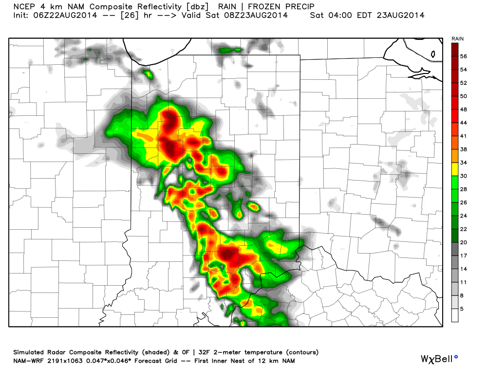
More Storms To Go…Our “ring of fire” pattern continues into the weekend and as disturbances ride the periphery of the heat dome to our south, periods of thunderstorms will be the result here.  Locally heavy rain will be possible with each storm complex and localized flooding will result.  Some extreme rainfall amounts of 5-8″ has been reported over the past couple days across north-central Indiana where training of storms has occurred.

After our current storm complex moves southeast, we think we deal with an additional couple of storm complexes late tonight into early Saturday and again Saturday evening.  Overall coverage of storms will be on the decline as we go deeper into the weekend, but rain can’t be totally eliminated from your forecast.

Hot And Humid…While we may fall a degree or two shy of the polarizing 90 degree mark, it’ll still feel mighty hot and humid today and Saturday. As rain and storm chances begin to decrease, that’ll allow us to take temperatures up a couple notches late weekend into early next week.  We forecast lower 90s Sunday through at least next Tuesday.

Late Month Relief…We still forecast a cooler pattern developing to wrap up August and move into September.  Much more on this in the coming days.  Right now, the big story remains the storm chances in the short term.

7-Day Precipitation Forecast:

  • 7-Day Rainfall Forecast: 2.00″ (locally heavier totals)
  • 7-Day Snowfall Forecast:  0.00″
Another complex of rain and strong storms will rumble in tonight/Saturday morning.

More Storms To Go…

Another night, another round of storms! Our busy and stormy “ring of fire” pattern continues and will promote additional storm complexes Friday morning (followed by more stormy times Friday night/…

You must be logged in to view this content. Click Here to become a member of IndyWX.com for full access.  Already a member of IndyWx.com All-Access?  Log-in here.