Brief: Heavy Snow & Sleet
Forecaster: McMillan

What: Heavy Snow & Sleet
When: 12a to 8a Wednesday
Temperatures: Upper 20s to lower 30s
Wind: E 15-25 MPH
Blowing/ Drifting: Moderate before mixing with sleet
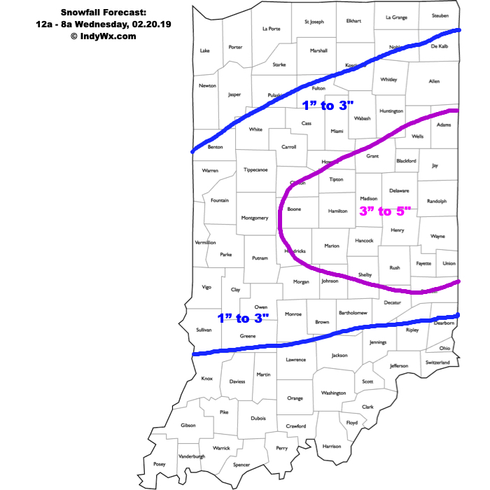
The setup remains the same as a warm front lifts north during the overnight. Copious amounts of moisture will arrive into central Indiana and with cold air in place, a period of moderate to heavy snow will develop. Timing into the city, itself, should come around, or just before, midnight. While the snow will be of the heavy, wet variety, gusty easterly winds will result in blowing and drifting snow (especially on north-south roadways) before precipitation transitions to sleet. We’ve “beefed” our accumulation forecast up to include a 3″ to 5″ band across east-central Indiana, including Indianapolis, as short-term guidance is indicating a period of significant “forcing” (or lift in the atmosphere) that will lead to heavy snowfall rates before the transition to sleet. A couple of hours with snowfall rates in excess of 1″ per hour will likely be observed in that 1a to 3a window. Precipitation will transition to sleet and a period of freezing rain between 3a and 5a from south to north, before turning to all rain in the city before sunrise. Further north, a transition to rain won’t be noticed until after 8a, but the majority of precipitation will likely be over with by that point (just lingering drizzle and fog).
Confidence: High

