 Highlights:
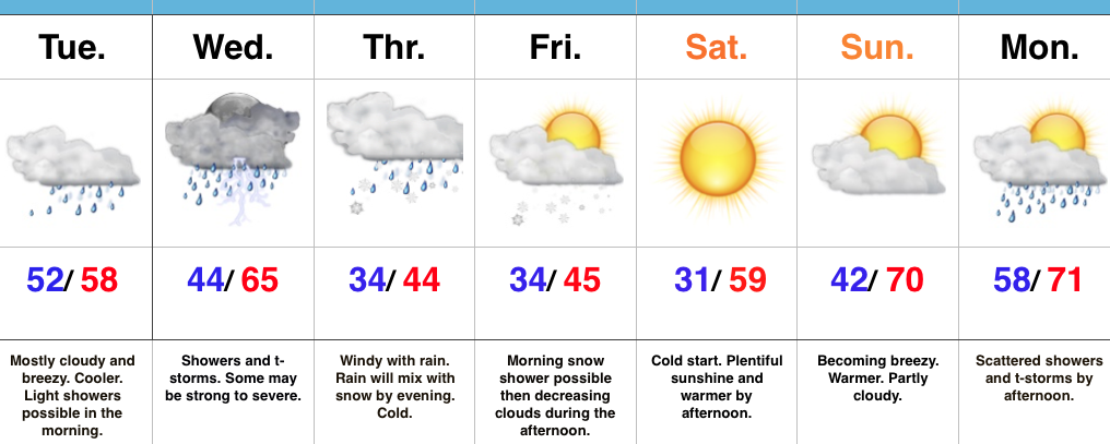
- Strong-severe thunderstorm potential Wednesday
- Turning colder to close the week with snow showers
- Beautiful weekend ahead
Changeable Weather…The region will be in between storm systems Tuesday. We think clouds will hang tough and the storms from overnight will move off to the east. In place, scattered showers will dot the north-central Indiana landscape especially through the morning hours.
A new storm system will take aim on the region Wednesday and strong to severe thunderstorms will be possible. Many questions remain in regards to instability, but shear will be plentiful and we’ll have to keep a close eye on future developments over the next 24-36 hours. Stay tuned. From this distance, conditions seem favorable for super cells to develop especially across southern Indiana. We’ll transition from storms to more of a wintry-like feel Thursday and Friday and continue to think the air will grow cold enough to support mention of wet snowflakes mixing with the rain by Thursday evening into Friday morning.
As we flip the page into the weekend, high pressure will build into the Ohio Valley and support increasingly sunny conditions. After a cold and frosty start Saturday morning, temperatures will rebound nicely under that strong early-April sunshine.
Our next storm system won’t begin to impact the region until Sunday afternoon (increasing southwest winds) and Monday (scattered showers and thunderstorms).
Upcoming 7-Day Precipitation Forecast:
- Snowfall: 0.00″
- Rainfall: 2.00″ – 2.25″
