 Highlights:
- Next weather maker arrives to close the work week
- Dry weekend coming
- Next storm system on deck
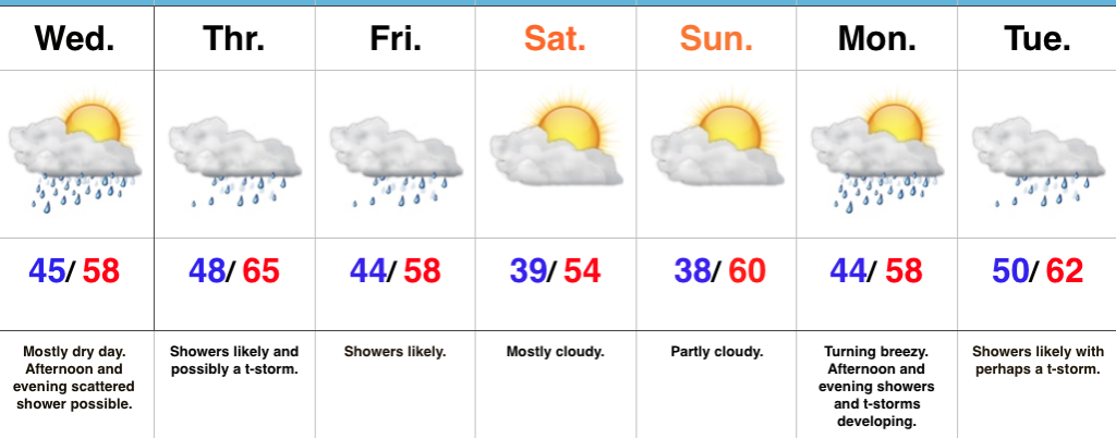
Rain Gear Needed To Close The Work Week…Wednesday will dawn with low clouds and areas of fog in spots, but that should diminish and possibly give way to a couple looks of the sunshine before our next storm system quickly approaches. If we see any sun Wednesday it won’t last long, as clouds will once again be on the increase Wednesday afternoon with a scattered shower possible. Rain coverage will become more widespread Thursday, and we’ll introduce a rumble of thunder into the forecast Thursday afternoon/ evening. Showers will continue Friday before scattering Friday afternoon.
The decreasing Friday afternoon rain chances signals a drier change that we’ll enjoy for the weekend (perfect timing)! High pressure will build into the region and support dry conditions. The temperature forecast is a bit tricky Saturday. We’re banking on a mostly cloudy sky that would limit highs into the middle 50s. Should we see more in the way of sunshine than currently expected, highs would zoom close to 60° Saturday. Dry conditions remain Sunday.
Our next storm system will result in increasing rain and storm coverage Monday afternoon, continuing into the day on Tuesday. If we look just beyond the forecast period, a shot of unseasonably cold air could send temperatures to sub-freezing levels by the latter parts of next week…
Upcoming 7-Day Precipitation Forecast:
- Snowfall: 0.00″
- Rainfall: 1.00″ – 1.50″
