 Highlights:
- Turning much colder tonight
- Light snow Thursday
- Bitterly cold, but dry weekend
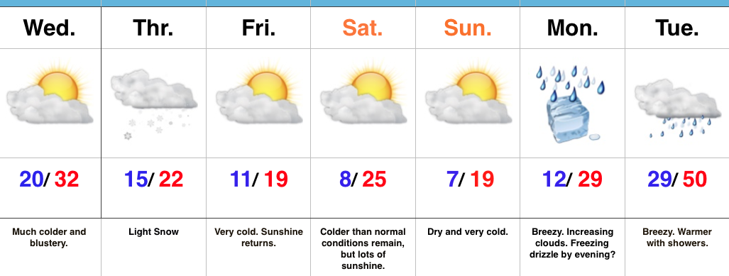
The Ice Box Returns…An arctic cold front will sweep through the state tonight and help usher in a drastically colder feel as we progress through the middle and latter parts of the week. Left over rain showers this evening may end as a couple of snow flurries before precipitation comes to an end. Winds will really increase tonight behind the cold front, gusting between 30 and 40 MPH. This will lead to single digit wind chill values out the door Wednesday morning.
Our next weather disturbance arrives Thursday morning and will help spread light snow across the southern half of the state. Snow will continue into the early afternoon before departing off to the east. Light accumulations (around 1″) will be possible, especially from Indianapolis and points south. We’ll keep an eye on fresh data coming into the forecast office tonight and update if need be.
Otherwise, the big story going into the weekend will be the return of bitterly cold air. In fact, overnight lows will drop into the single digits Saturday and Sunday mornings. Dress warmly if you have plans to be outside for any length of time.
Our air flow will back around to the southwest early next week and temperatures will begin to moderate. Moisture may make it to the surface to create a little spotty freezing drizzle Monday evening before temperatures sky-rocket to around 50 Tuesday as showers return.
Upcoming 7-Day Precipitation Forecast:
- Snowfall: 1.00″
- Rainfall: 0.25″ – 0.50″
