 Highlights:
- Even colder this week than last
- Light snow chances
- Bigger storm next weekend
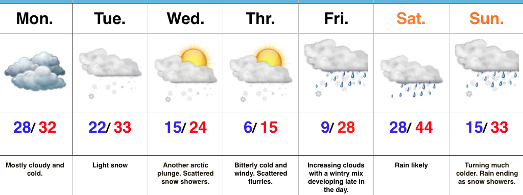
Bitterly Cold Week Ahead…We’ll kick off the work week with mostly dry, but mostly cloudy and continued cold conditions. Be careful if traveling early in the morning as some refreezing may take place across central IN during the overnight.
Reinforcing arctic air will begin to blow into town mid week and an area of light snow may precede this next arctic punch to the gut Tuesday. Scattered snow showers and flurries will fly in the bitterly cold, arctic, air mass Wednesday and Thursday. Along with highs only in the teens Thursday, expect below zero wind chills.
Eyes will then shift to the end of the week as our next storm of significance approaches. This storm appears to be stronger than this past weekend’s system, but similar to this weekend’s overall pattern, we expect a “mild up” and mostly a liquid event across central parts of the state. The primary reason? Lack of high latitude blocking to keep the storm track south (more on that in another post later tonight or Monday). Add in a “feisty” southeast ridge that keeps flexing it’s muscle and you have the makings for what’s likely another cutter to the Lakes. Unlike this current event, we will have to keep an eye on a potential second wave of moisture moving along the front Sunday as the arctic air returns.
Upcoming 7-Day Precipitation Forecast:
- Snowfall: 1″ – 2″
- Rainfall: 0.75″ – 1.00″
