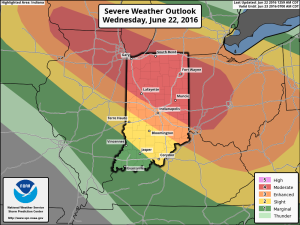
The first of two waves of showers and thunderstorms is moving through the region this morning. It’s the second wave of storms this evening/ tonight that has most of our attention.
The Storm Prediction Center has included more of central IN in a Moderate Risk of severe weather with the morning update.
 All modes of severe weather are possible this evening and tonight, including tornadoes, hail, and damaging straight line winds. Localized flash flooding is also possible where storms train.
Specific timing remains in question and we’re still not confident in the way short-term model data is handling the situation. Fine tuning will be required as we move into the afternoon hours.
Once we rid the morning storms, clearing should develop for the afternoon and help boost temperatures into the middle 80s. Sunshine is a bad thing this afternoon. It won’t take much to destabilize things and ignite the second round of storms to our northwest this evening (southern WI/ northern IL). That second round of storms is the one expected to pack a punch for some as they race southeast.
Have a means to get the latest weather information later today and ensure your family’s severe weather plan is in place.
Much more later this afternoon!
