Updated 02.17.21 @ 8:06a
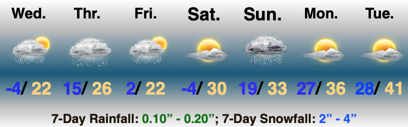
Snow Builds Back In…As easy as the previous storm was, this one has been a royal pain in the neck. Stubbornly, I anticipated a further northwest shift (especially given the PNA state), but that’s not to be the case. While southern and southeastern Indiana will tack on a few additional inches with this storm, this is a 1″ to 2″ type deal for central Indiana, and most of that falls tomorrow morning into Thursday afternoon.
A few lingering light snow showers are possible Friday followed by clearing. High pressure will build overhead Friday night and set us up for another “nasty” cold night. Temperatures will likely rival where we are this morning come Saturday morning as winds go calm and skies clear.
The next potential trouble maker looms on the horizon Sunday. Models are beginning to slowly understand that we’re simply not going to dislodge all of this cold air in quick fashion. As such, a wintry mix and/ or wet snow is becoming increasingly likely by Sunday PM into Sunday night as this system blows through.
Quiet conditions return into early portions of the work week.
Averages: H: 41°/ L: 24° on the 17th –> H: 43°/ L: 26° on the 23rd
Leave a Reply