Updated 02.10.21 @ 6:23p
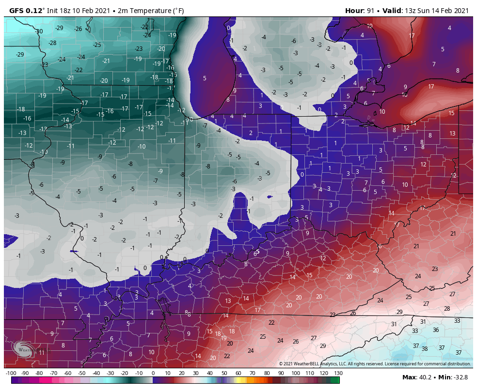
Before we look ahead, snow continues to fall across most of central Indiana. So far, immediate downtown Indy has avoided significant snow, but other areas are approaching 1″ to 2″ already as of this post. We continue to believe another band of snow will organize during the overnight into the predawn hours across central Indiana (especially along and north of the I-70 corridor). Given how cold it’s been as of late, even the lightest snow is creating havoc on area roadways. As winds become gusty, blowing and drifting issues will remain into the day Thursday.
As we look ahead, this pattern remains nothing short of remarkable. Feb. 5th (last Friday at 6p) was the last time Indianapolis was above the freezing mark. As we look ahead, we’re likely talking about another 12 days below freezing (if not longer). The “moderation” that some models are hinting at after that time frame isn’t something I’d label as high confidence at this point. That’s rare territory for central Indiana- even during some of the infamous cold winters of the “good ole days.” There’s also already been a fair share of snow events in this pattern. Sure the big one hasn’t hit (yet), but many across the state are getting used to clearing snow off the sidewalk and driveway on a daily basis. Not counting today’s snow, Indianapolis, officially, sits at 2.3″ month-to-date. Areas downstate received as much as half a foot (or more) earlier this week. As we look ahead, there’s a lot more white gold where that came from. (Keep in mind, the “average” snow total during the month of February in Indianapolis is 6.5″).
A fresh intrusion of arctic air will arrive just in time for the weekend. We’re looking at a mostly dry stretch of weather through the weekend, with the exception of some light snow prospects Saturday. Again, given how cold it’s been, even these light snow events will likely create travel trouble.
The coldest morning appears to be Sunday with lows falling to between 3° and 6° below zero. Wind chill values will approach 20° below zero, or worse, in spots.

By this time, all eyes will be on the developing storm system in the northwest Gulf of Mexico. There’s already been a great deal of chatter about this storm and that will only continue to ramp up as we move forward. Given the overall pattern and model consensus at this juncture, there’s plenty reason to believe the Ohio Valley, including central Indiana, is in store for a significant winter storm early next week.
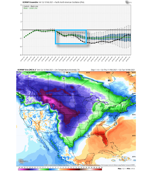
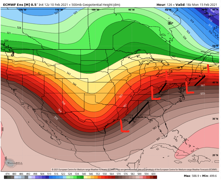
With that said, nothing is a lock in this business. While the negative PNA (image 1 below) argues for the southeast ridge to “flex” it’s muscle and lead to a more inland track, the fact arctic air will be pressing southeast (image 2 below) does at least raise an eyebrow for potential shifts southeast in time over the next couple of days. It’s another fascinating meteorological battle we’ll have the pleasure to watch unfold in real time.
As it sits right now, we favor a storm track that will be far enough west to put central Indiana in play for potentially significant wintry precipitation (far too early to throw numbers out). The early call is for surface low to move out of the northwest Gulf and track west of the mountains before a secondary low take over along the Mid-Atlantic and moves northeast off the New England coast.
If this wasn’t enough, another storm system likely follows later next week that could also produce additional wintry “goods.”
Will every storm produce in your backyard? Negative. That said, when we get to March 1st, central Indiana winter weather fans are likely to look back on February 2021 as a truly special ride.
I suppose time will tell…
Leave a Reply