Type: Impactful Wintry Weather

What: Accumulating Snow/ Wind
When: Today through Tuesday Morning
Temperatures: Upper 20s to lower 30s
Wind: NW 15-20 MPH; Gusting to 35 MPH
Blowing/ Drifting: Moderate, especially with late afternoon-evening lake-effect snow band.
Pavement Impacts: Salting required; plowing required within lake-effect snow band.
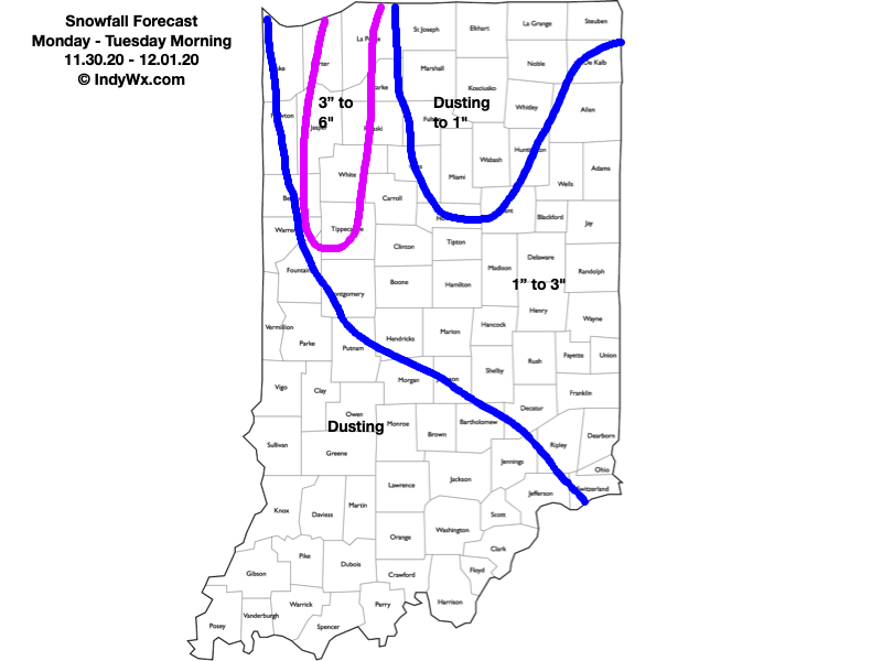
Summary: We’ll undergo a transition from “system” snow (mostly light) this morning into early afternoon to a more localized, but robust lake-effect snow event late afternoon and this evening. At least for central portions of the state, this is the better opportunity for accumulating snow. As temperatures continue to fall and the wind direction becomes better aligned, a band of lake effect snow is expected to develop initially across northwestern Indiana late morning. It’s this band of snow that should continue to get better organized and heavier as we move into late afternoon and the evening hours and be driven well inland. Eventually, this lake snow band should reach areas as far south as Indianapolis (and surrounding ‘burbs) by late afternoon, potentially including the 5 o’clock rush for parts of the city. Snowfall intensity within this band is expected to be heavy enough to whiten roadways and create slick spots. For most this will only last an hour or two before the band pivots east and impacts east-central Indiana for a longer period of time into the overnight and early Tuesday morning. If you find yourself under this lake effect snow band, a quick 1″ to 2″ can be expected
Confidence: High
Next Update: Tonight (video package)
Leave a Reply