January 2024 archive

VIDEO: Snowy Close To The Week; Final Arctic Hammer Drops This Weekend Before Significant Pattern Change…

Updated 01.17.24 @ 6:58a A band of snow will drop south into north-central IN Thursday morning, likely making it as far south as the Indianapolis-area proper before falling apart. This…

You must be logged in to view this content. Click Here to become a member of IndyWX.com for full access.  Already a member of IndyWx.com All-Access?  Log-in here.

Permanent link to this article: https://indywx.com/2024/01/17/video-snowy-close-to-the-week-finally-arctic-hammer-drops-this-weekend-before-significant-pattern-change/

Snow Event And Arctic Reinforcements To Close The Week; Active Storm Track Ahead…

Updated 01.16.24 @ 12:34p

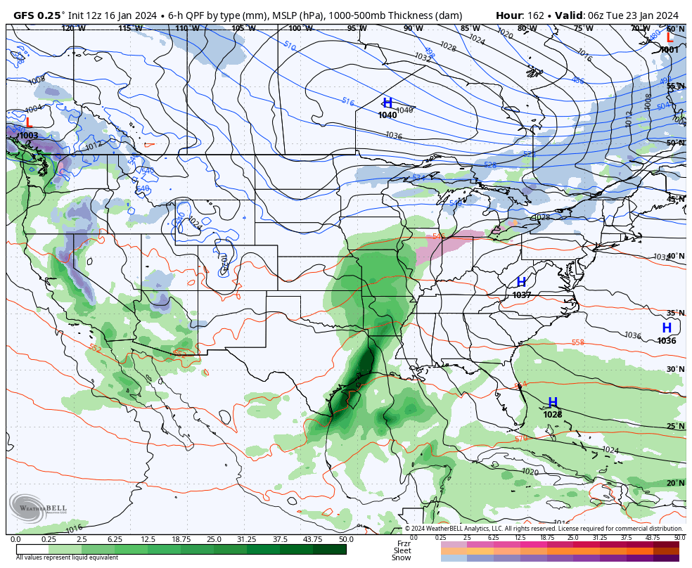
Today and most, if not all, of Wednesday will be plain ole cold but at least precipitation free. We’ll have to watch short term guidance closely for a band of snow that will develop across northern Indiana overnight and into Thursday morning. We think this snow band will sink south into at least north-central Indiana after sunrise Thursday before falling apart likely around Indianapolis. A quick 1”-2” of snow is likely across northern and north-central Indiana Thursday morning.

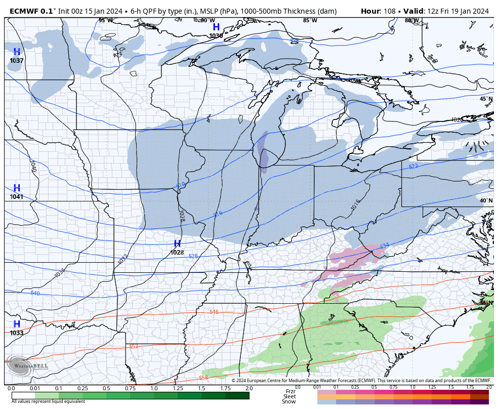
Our next opportunity of snow (area wide) will move in Thursday night and Friday morning. This will be a much higher ratio type snow (think 20:1) than typical with the cold, arctic airmass in place. We should easily be able to accumulate 2”-4” with this event, with the potential of a couple 4”+ reports. (Snow removal clients, plowing and salting will be activated by Thursday evening).

A fresh round of bitter, arctic air flows in as we kick off the weekend. With a fresh snowpack, another round of subzero lows should be expected. Look for highs in the 10s Saturday and 20s Sunday. Wind chill values will dip to around -20° as we kick off the weekend.

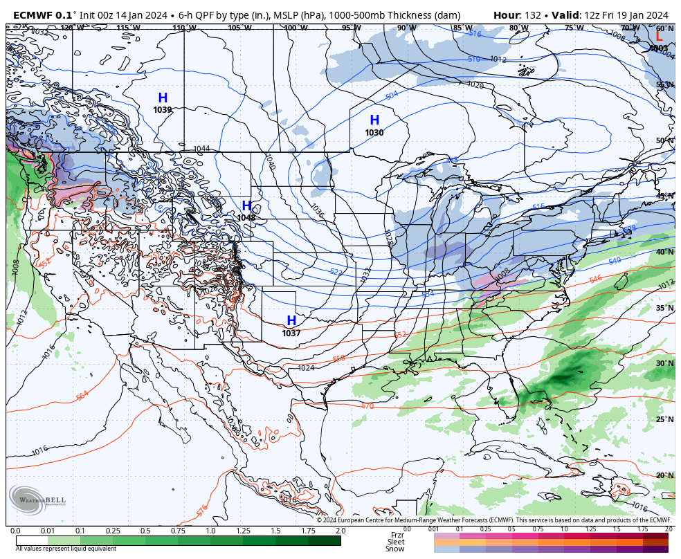
Though a moderating trend will kick in in full force next week, we’ll have to watch for the potential of a freezing rain and/ or sleet event Monday night into Tuesday (arctic air is always slower to erode than usually modeled) and a true shift to a wet pattern for the middle and latter part of next week.

Permanent link to this article: https://indywx.com/2024/01/16/snow-event-and-arctic-reinforcements-to-close-the-week-active-storm-track-ahead/

Bitter Week Ahead: Talking Snow Chances And Arctic Reinforcements For The Weekend…

Updated 01.15.24 @ 6:29a

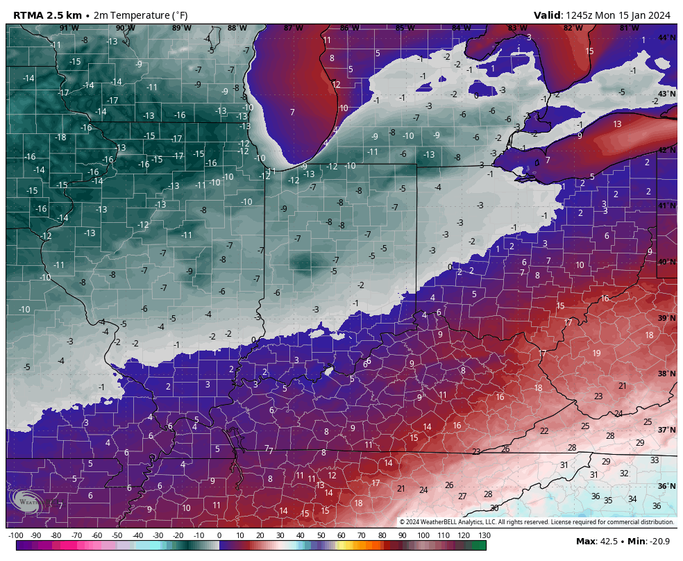
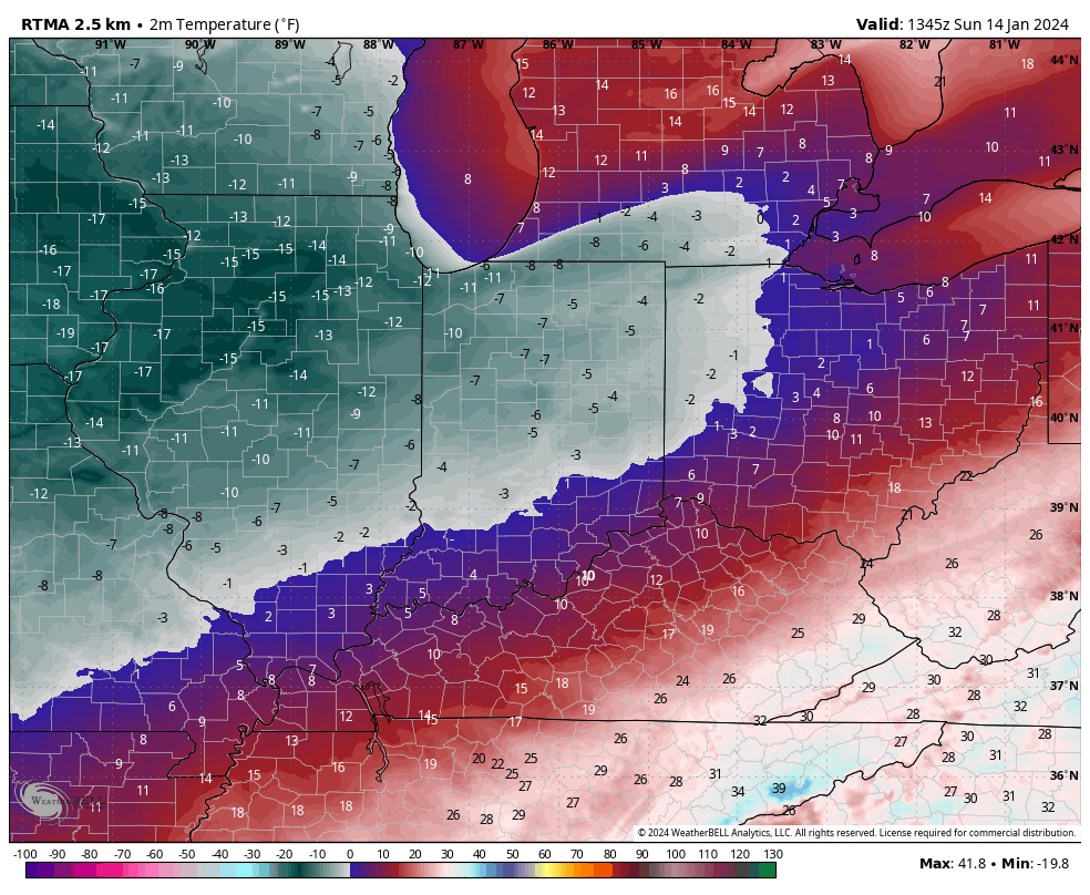
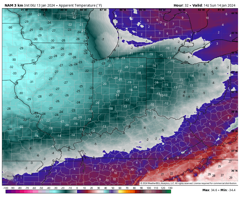
Officially, IND dipped to 4° below zero Sunday morning with a high of only 12°. We’re even colder this morning across the area, including double digit below zero readings north and 6° to 9° below zero for most central IN neighborhoods.

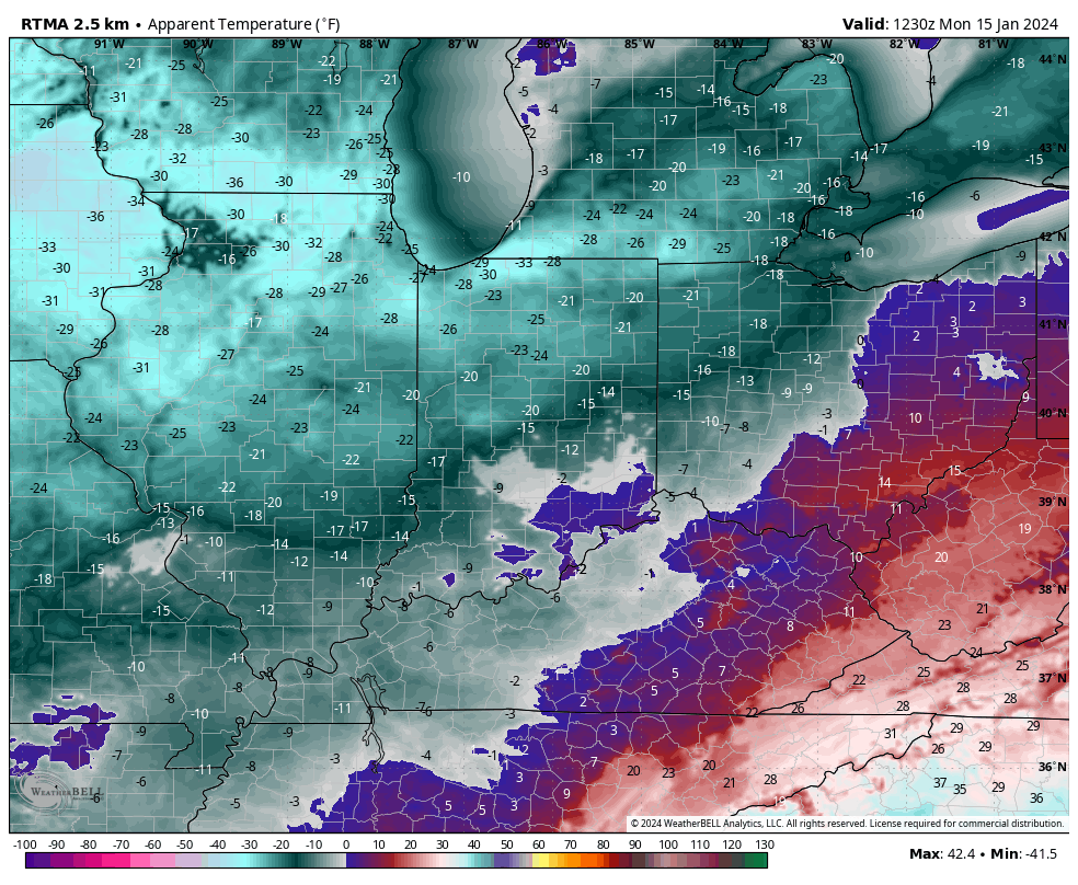
It’s another frigid start to the morning across central Indiana.
Monday morning wind chill values

Another round of light snow will scoot through central IN tonight, accumulating anywhere from 0.50” to just under an inch.

The next chances of snow come late week, in advance of arctic reinforcements for the weekend (we think we go back below zero over the weekend). We’re tracking Wednesday night into Thursday morning and Thursday night into early Friday for the next rounds of snow- both of which should be light events but will add up to a couple if not several inches when all is said and done (2”-4” for most is a reasonable call from this distance).

Wednesday night – Thursday morning
Thursday night – Friday

That fresh snowpack will lay the ground for a renewed batch of arctic air for the weekend, including lows back to below zero and highs in the 10s.

Permanent link to this article: https://indywx.com/2024/01/15/bitter-week-ahead-talking-snow-chances-and-arctic-reinforcements-for-the-weekend/

Sunday Morning Rambles From The Deep Freeze…

Updated 01.14.24 @ 7:13a

Hoosiers are waking up to subzero temperatures this morning. We note double digit below zero readings now penetrating into northwest parts of the state. Wind chill values are dangerously cold.

Highs today will barely sneak into the single digits as the true arctic air mass continues to have a tight grip on the region.

Some light snow may scoot through the area Monday evening into Tuesday morning. This won’t amount to much even if it does materialize. (Dusting to half inch of snow if that).

The next opportunity for potentially more meaningful snow arrives late week – in the Thursday PM through Friday timeframe, preceding another intrusion of bitter arctic air to open next weekend.

For folks longing for milder times, hang in there. A pattern change still seems afoot come late month. This January thaw may even take highs back into the 40s and 50s ahead of a reloading of cold times as we flip the page to February.

Permanent link to this article: https://indywx.com/2024/01/14/sunday-morning-rambles-from-the-deep-freeze/

Bitter Cold Settles In; Looking At Snow Chances In The Week Ahead…

Updated 01.13.24 @ 6:57a

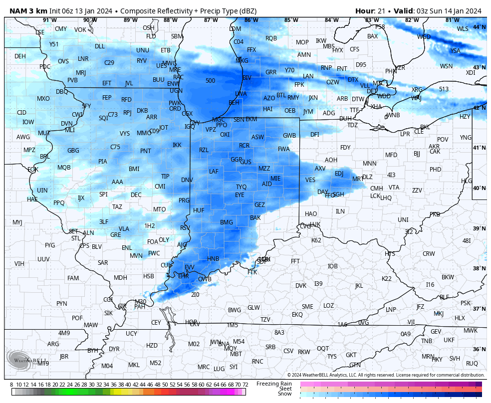
We’re waking up to light snow this morning in the wake of our departing strong storm. As a new (albeit much, much weaker) disturbance moves across the Ohio Valley tonight, snow will increase in coverage and intensity this evening, continuing into early Sunday morning. At times, snow may fall at moderate intensity. This is all a byproduct of maximizing every bit of available moisture as the true bitter arctic air rolls into town. We’ll also need to be prepared for blowing and drifting issues.

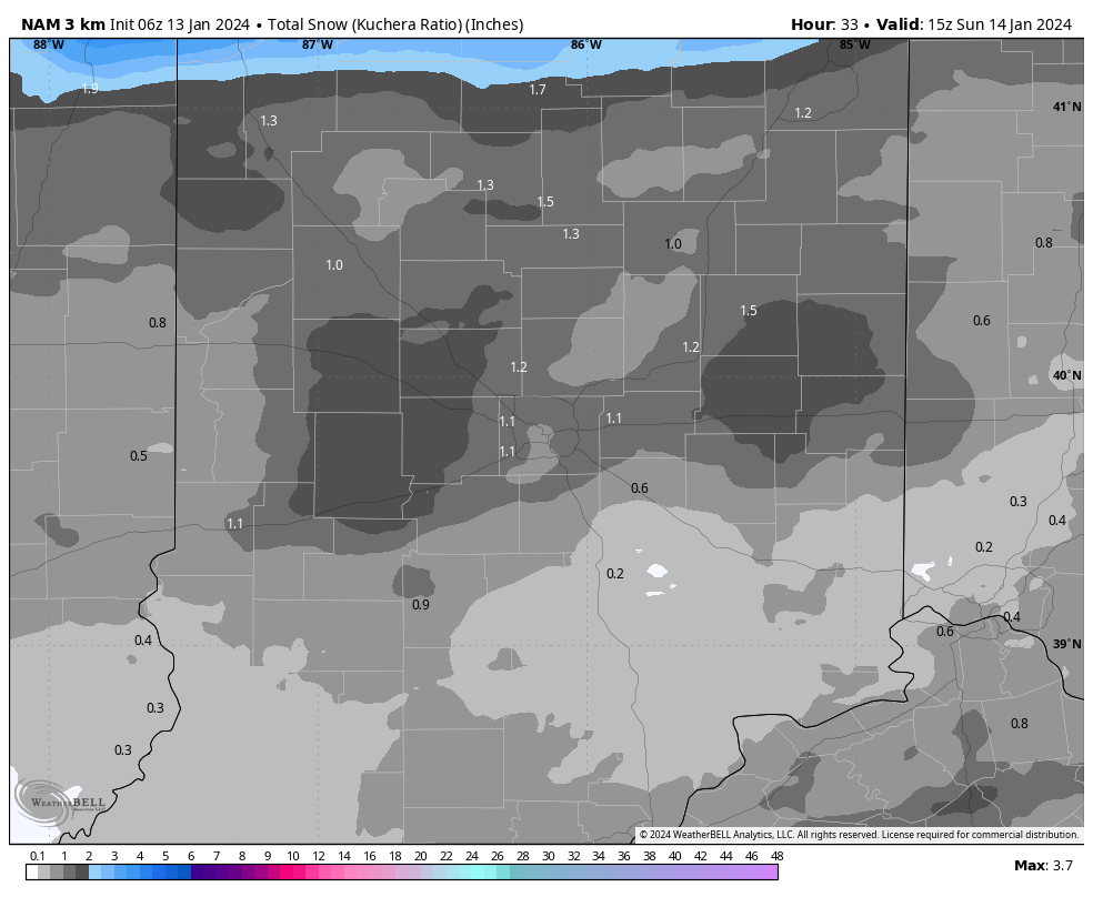
A fresh 0.5” to 1.5” (may see a couple local reports of 2”) of snow can be expected with this system.

By tomorrow morning, dangerous wind chill values of 20° to 25° below zero can be expected.

“Cold” is the word in the week ahead but we’ll also monitor a couple of quick moving opportunities of additional snow. While it still doesn’t appear that anything overly heavy is on the table, it won’t take much for these systems to overachieve in the bitter arctic air (“fluff factor” will be present in the upcoming week). With the cold, even light snow events will make a mess of area roadways, so be sure to allow extra time to safely reach your destination.

It continues to appear that the system Monday into Tuesday will take a more suppressed route. We don’t expect much, if anything, here across central Indiana from a snow standpoint. Our eyes continue to focus in on Thursday/ Friday. The jet may buckle just enough to allow energy to slow down and organize a bit more to generate a more widespread snow event across our neck of the woods, but even this is admittedly tricky from this distance- just something we’ll continue to closely monitor in the week ahead.

One thing is for sure, whatever snow does fall in this pattern won’t be going anywhere as frigid as we’re going to be. Stay safe (and warm), friends!

Permanent link to this article: https://indywx.com/2024/01/13/bitter-cold-settles-in-looking-at-snow-chances-in-the-week-ahead/

Prolonged Period Of Bitterness, But A Change Is On The Horizon…

Updated 01.12.24 @ 12:18p

The upcoming 10-days is a case of cold and if you believe some of the guidance, even colder (next weekend). Multiple nights below zero and dangerous wind chill values of 20° to 30° below zero are on tap at times during this period. You know that we’re interested to see if we meet our respective targets. It’s not just the magnitude of the cold, but the duration and widespread nature, as shown over the upcoming 10-day temperature anomalies from last night’s European ensemble.

But milder changes are on the horizon as we rumble through the warmer phases (at least this time of year) of the MJO and see some temporary trends within our teleconnection suite (AO, NAO, EPO, and PNA) that favor a period of much less harsh, and even milder than normal conditions developing by the last week of the month.

After our frigid stretch, temperatures even only a few degrees above normal will feel like a heatwave.

The hunch here is that we return to another cold stretch as we rumble into February. Long range guidance shows “part 2” of our high latitude blocking event and the thought here is this is a byproduct of a combination of sea surface temperature (SST) configuration in the northwest ATL, the current state of our Nino, as well as the SST configuration in the central/ northern PAC. At any rate, the alignment between teleconnections and, of course, the MJO rolling into the colder phases supports this idea. Let us worry about that and you enjoy the late month “mild-up!” Heavens knows after these next couple weeks, you will have earned it!

We’ll continue to keep tabs on the threat of snow over the next couple weeks. Things can, obviously, change but as of now I’m not seeing any hefty snow threats for central Indiana. The one feature that does potentially require watching is out there towards the end of next week, but the overall fast paced flow should prevent this from deepening into anything overly significant. At least that’s the way we see it now.

We’ll continue to keep close tabs on short-term trends but feel good with what we have out there concerning rain/ snow amounts, timing of the transition, and damaging wind potential.

Permanent link to this article: https://indywx.com/2024/01/12/prolonged-period-of-bitterness-but-a-change-is-on-the-horizon/

VIDEO: Conditions Go Down Hill Through The Day; Bitterly Cold Pattern On Tap…

Updated 01.12.24 @ 6:22a A potent storm system will deal out a multitude of weather conditions over the next 12 to 18 hours, including strong winds, heavy rain, and light…

You must be logged in to view this content. Click Here to become a member of IndyWX.com for full access.  Already a member of IndyWx.com All-Access?  Log-in here.

Permanent link to this article: https://indywx.com/2024/01/12/video-conditions-go-down-hill-through-the-day-bitterly-cold-pattern-on-tap/

VIDEO: Long Range Manifesto And Fresh Thoughts On Friday/ The Weekend…

Updated 01.11.24 @ 6:12p Busy times remain in the good ole forecast office! This evening we dig into not only new long range thoughts but look deeper into the latest…

You must be logged in to view this content. Click Here to become a member of IndyWX.com for full access.  Already a member of IndyWx.com All-Access?  Log-in here.

Permanent link to this article: https://indywx.com/2024/01/11/video-long-range-manifesto-and-fresh-thoughts-on-friday-the-weekend/

VIDEO: Prolonged Cold, Wintry Pattern…

Updated 01.11.24 @ 7:07a Yet another strong storm system (we may break minimum pressure records once again) will roll across the state Friday leading to a wind-whipped heavy rain event…

You must be logged in to view this content. Click Here to become a member of IndyWX.com for full access.  Already a member of IndyWx.com All-Access?  Log-in here.

Permanent link to this article: https://indywx.com/2024/01/11/video-prolonged-cold-wintry-pattern/

Client Brief: Rain To Snow? Yes, But Bigger Deal Damaging Wind Potential And Bitter Cold…

Updated 01.10.24 @ 5:33p

Type: Severe Winter Weather

A prolonged period of strong, gusty, and potentially damaging winds will develop Friday into Saturday.
Expected maximum wind gusts

What: Rain changing to snow; prolonged period of strong winds, and bitter cold

When: Friday, 1/12/24 and Saturday, 1/13/24

Wind: Variable 20-30 MPH with gusts to 50 MPH

Temperatures: Middle 40s Friday falling below freezing Friday night and below zero by Sunday morning.

Pavement Impacts: Salting will be required Friday night through the weekend.

Summary: A rapidly deepening area of low pressure will track through central Indiana Friday. What will likely be a SLP in the low 990s (millibars) Friday morning is liable to be in the low 970mb range by Friday night in southern Michigan. This will undoubtedly lead to a “big blow” across all of the region as we close out the work week and head into the weekend and that’s where we want to start with the headlines. A prolonged period of 20-30 MPH winds with gusts close to 50 MPH can be expected during this time frame.

As far as precipitation goes, rain is forecast to move into central Indiana Friday morning, falling heavy at times. If you have travel plans up north across northern Indiana, more in the way of wet snow is forecast during this time period. We’re not expecting to transition to snow until after sunset Friday (from west to east) as colder air pours in on the backside of the strengthening low. Snow showers will continue to fall into Saturday morning and with the strong and gusty northwest winds in place, lowered visibility and some slick spots can be expected across the region. Only light snow amounts are forecast, locally, to the tune of 0.50″ to 1.50″, but good luck measuring that in all of the wind. Scattered snow showers (arctic haze) will continue into Sunday as brutal arctic air oozes into the region.

Confidence: High

Next update: 7:30a Thr

Permanent link to this article: https://indywx.com/2024/01/10/client-brief-rain-to-snow-yes-but-bigger-deal-damaging-wind-potential-and-bitter-cold/

IndyWx.com