Updated 05.31.23 @ 7:24a
You must be logged in to view this content. Click Here to become a member of IndyWX.com for full access. Already a member of IndyWx.com All-Access? Log-in here.

May 31
Updated 05.31.23 @ 7:24a
You must be logged in to view this content. Click Here to become a member of IndyWX.com for full access. Already a member of IndyWx.com All-Access? Log-in here.
Permanent link to this article: https://indywx.com/2023/05/31/video-widely-scattered-showers-this-evening-cooler-pattern-next-week/
May 30
Updated 05.30.23 @ 7:24a
You must be logged in to view this content. Click Here to become a member of IndyWX.com for full access. Already a member of IndyWx.com All-Access? Log-in here.
Permanent link to this article: https://indywx.com/2023/05/30/video-isolated-storms-heat-builds-into-the-weekend/
May 29
Updated 05.29.23 @ 10:20a
You must be logged in to view this content. Click Here to become a member of IndyWX.com for full access. Already a member of IndyWx.com All-Access? Log-in here.
Permanent link to this article: https://indywx.com/2023/05/29/happy-memorial-day-pattern-heats-up-this-week/
May 28
Updated 05.28.23 @ 8:31a
You must be logged in to view this content. Click Here to become a member of IndyWX.com for full access. Already a member of IndyWx.com All-Access? Log-in here.
Permanent link to this article: https://indywx.com/2023/05/28/video-heat-builds-briefly-this-week-better-chances-of-rain-precede-cooler-week-2-pattern/
May 27
Updated 05.27.23 @ 10:32a
Meteorological summer (June through August) is only a few days away and, as you’d imagine, hotter days are on tap. BUT…we continue to believe the 90° days will be brief over the next couple of weeks.
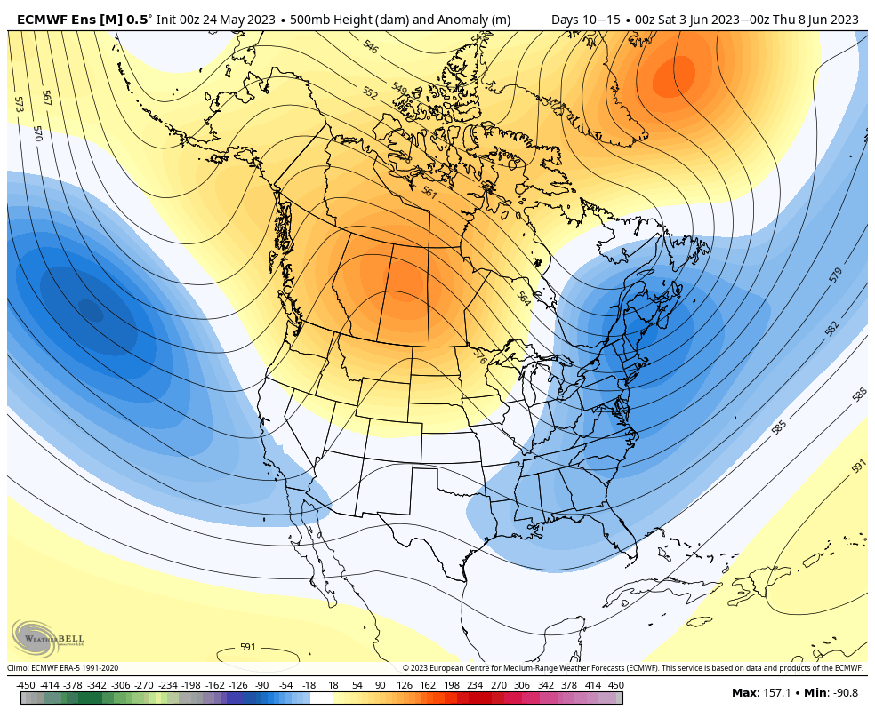
Note the upper pattern evolution shown below. Upper ridging briefly expands over the northern Great Lakes into the Ohio Valley and north-central in the Day 2-7 time period. However, by the Day 10-15 period, that same ridge has retrograded northwest in significant fashion and a significant eastern trough takes up residence.
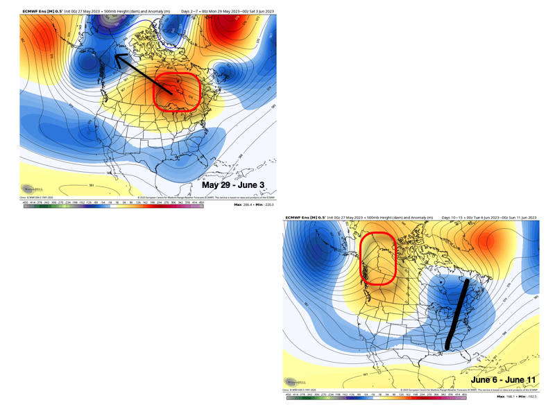
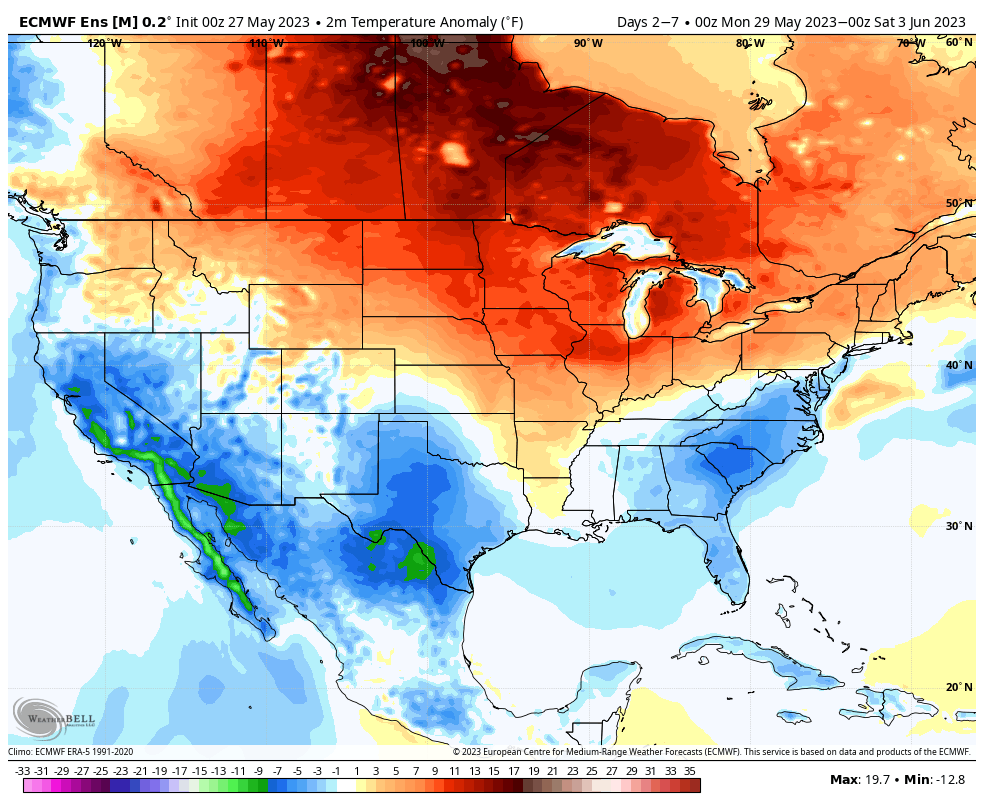
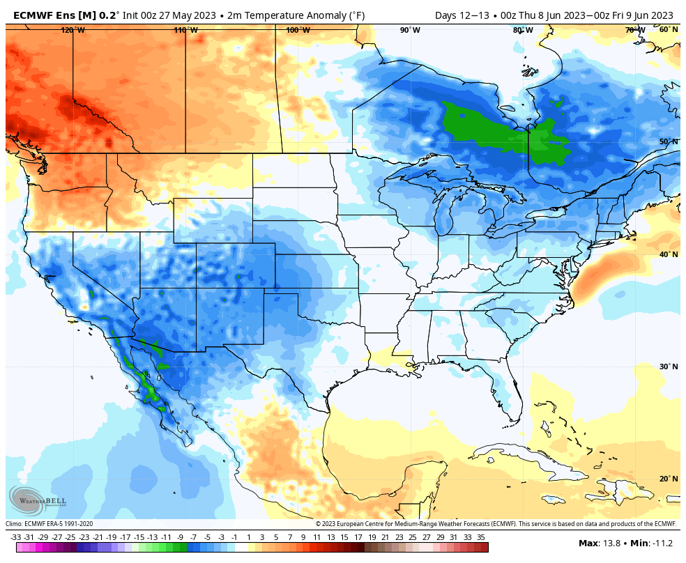
The transitional hotter pattern of next week will be replaced with cooler than normal temperatures during the second full week of June.
The reason for such a pattern transition as noted above has to do with (2) primary drivers: the EPO tanking negative just past the beginning of the month and the PNA spiking strongly positive.
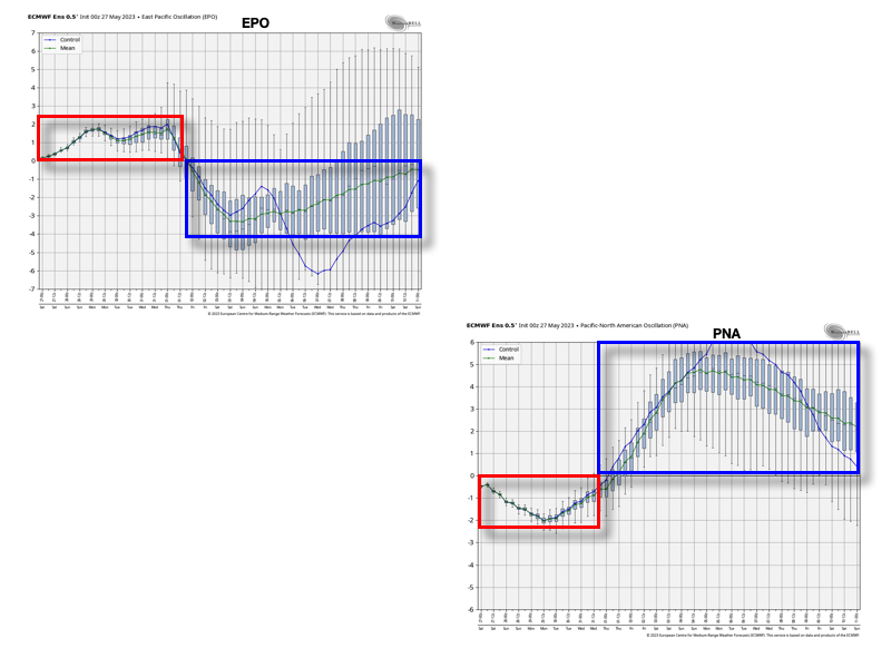
These will work in tandem to pull that upper ridge and associated hot dome into what will likely be more of a permanent June position while the ‘mean’ trough will likely reside in the eastern portion of the country for the better part of the first month of meteorological summer.
While still not an overly wet pattern by any stretch of the imagination (remember, we don’t think wholesale changes take place in the precipitation pattern until the 2nd half of the summer this year), the transition of regimes will likely generate at least better opportunities for needed moisture in the Week 2-3 period.

Permanent link to this article: https://indywx.com/2023/05/27/doubling-down-on-the-june-pattern-transition/
May 27
Updated 05.27.23 @ 8:58a
You must be logged in to view this content. Click Here to become a member of IndyWX.com for full access. Already a member of IndyWx.com All-Access? Log-in here.
Permanent link to this article: https://indywx.com/2023/05/27/all-important-race-day-forecast-moisture-levels-slowly-rise-next-week/
May 26
Updated 05.26.23 @ 7:40a
You must be logged in to view this content. Click Here to become a member of IndyWX.com for full access. Already a member of IndyWx.com All-Access? Log-in here.
Permanent link to this article: https://indywx.com/2023/05/26/video-warming-trend-develops-into-next-week/
May 25
Updated 05.25.23 @ 9:44a
You must be logged in to view this content. Click Here to become a member of IndyWX.com for full access. Already a member of IndyWx.com All-Access? Log-in here.
Permanent link to this article: https://indywx.com/2023/05/25/lr-update-next-weeks-heat-doesnt-last-pattern-turns-much-cooler-in-the-week-2-time-period/
May 24
Updated 05.24.23 @ 12:26p
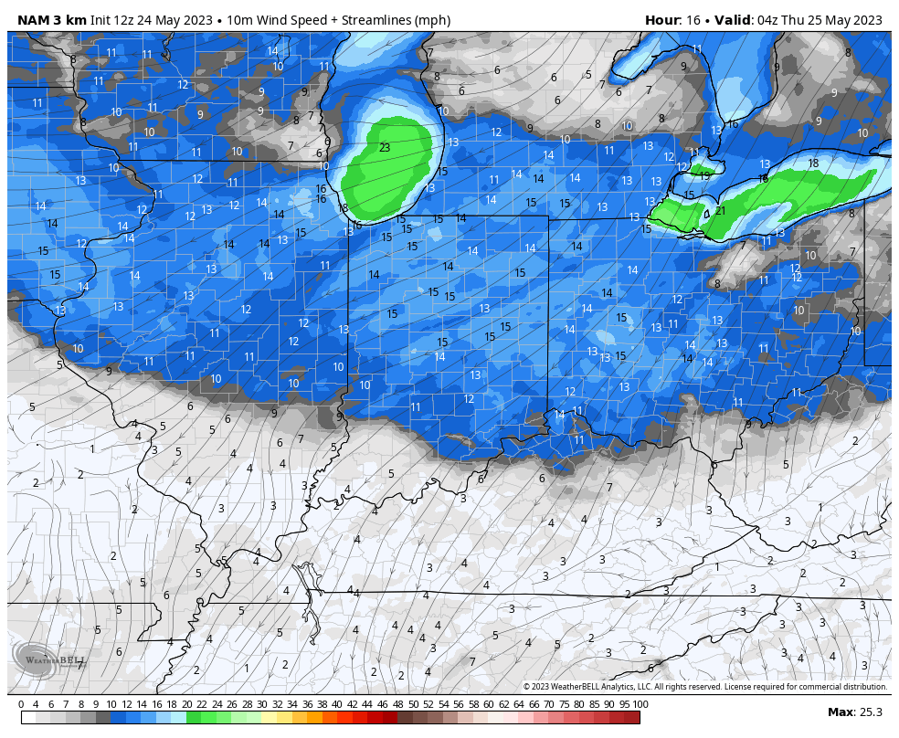
A dry cold front will pass through the state this afternoon. While we won’t see any precipitation from this frontal boundary, northeast winds will turn gusty into the evening and much cooler temperatures will greet us out the door Thursday morning. Some outside of the city, itself, might wake up to temperatures into the upper 30s!
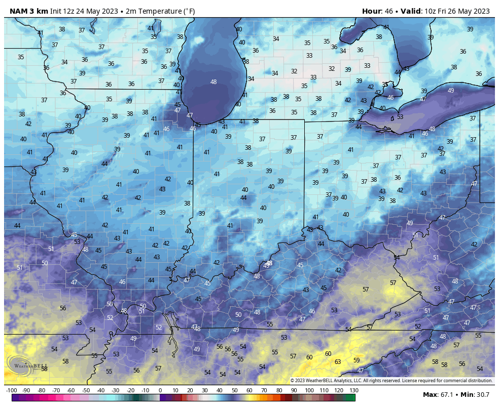
Highs will top out in the middle to upper 70s as we close out the work week before creeping back up north of 80° over the weekend and Memorial Day, itself. Dry and sunny conditions can be expected through the period.
While we’re continuing to keep eyes on the upper low to our south, as of now, it still doesn’t appear as if it’ll have much, if any, impact on our weather, and we’ll maintain a dry approach for race day and the holiday, itself.
Heat should temporarily build next week, including the potential of a few 90° days, but we don’t envision this hotter pattern holding. Just past Day 10 eastern troughiness is already returning (image 2 below). This evolution will likely generate better rain chances in the Week 2 timeframe as well.

Permanent link to this article: https://indywx.com/2023/05/24/cooler-but-dry-time-holds/
May 23
Updated 05.23.23 @ 7:56a
As the old saying goes, there’s no reason to waste any pixels on the short-term forecast through Friday. We’re simply on “cruise control” as a dry frontal passage serves up some reinforcing cool Canadian air.
Things become a bit more tricky as we get into the all-important weekend though, thanks to the potential influence of an upper level low and additional upper air disturbances scooting in from the west.

As of now, the call remains for dry weather to hold across central Indiana through the holiday weekend, but we’ll be keeping close eyes on both features above for the threat of any last minute changes.
Unlike many similar setups in years past, the local airmass will be much drier than normal so it’ll take a lot for big changes to take place for the wetter. That said, given all going on between Friday and Monday, we’ll continue to closely monitor. If (big “if”) rain chances need to be introduced, it appears as if Sunday evening into Sunday night would offer up the best opportunity for a few showers.
Permanent link to this article: https://indywx.com/2023/05/23/all-eyes-on-the-weekend/