March 2020 archive

VIDEO: Wet Snow Accumulates For Some Today; Severe Weather Set-Up Late Next Week…

You must be logged in to view this content. Click Here to become a member of IndyWX.com for full access.  Already a member of IndyWx.com All-Access?  Log-in here.

Permanent link to this article: https://indywx.com/2020/03/14/video-wet-snow-accumulates-for-some-today-severe-weather-set-up-late-next-week/

March Snow Events Are Always Fun: Discussing Placement/ Accumulation Amounts…

Saturday morning will open with a lowering and thickening cloud canopy and moisture will soon follow. We expect precipitation to arrive first on the scene across north-central Indiana (between 8a and 10a) and likely fall predominantly as wet snow. Further south (closer to Indianapolis), a mixture of rain and snow is expected to develop between 11a and noon. All rain is anticipated across southern parts of the state.

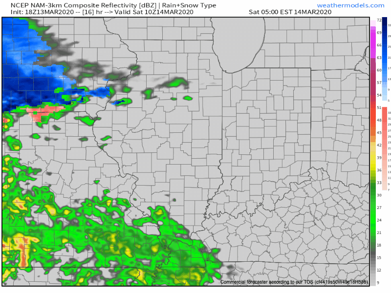
Once the precipitation arrives, it’ll set up shop for the better part of the rest of the day. It won’t be until closer to the 7p to 9p timeframe that we’ll begin to see the mixture of rain and snow exit the state from west to east.

Temperatures will be marginally cold (lower-middle 30s) throughout the event, and we’ve also discussed the challenge of getting snow to accumulate with that increasingly high March sun angle. That said, even with marginally cold temperatures, if we can generate heavier precipitation rates, areas north of the city can expect to accumulate an inch or two of wet snow. Significant pavement impacts aren’t expected.

Here’s our snowfall forecast:

Temperatures will fall into the upper 20s to around 30 for all of central Indiana Saturday night and Sunday morning. Thankfully, high pressure will return and provide increasing sunshine for the 2nd half of the weekend. It’ll still be chilly with highs topping out in the middle 40s.

Permanent link to this article: https://indywx.com/2020/03/13/march-snow-events-are-always-fun-discussing-placement-accumulation-amounts/

Old Man Winter Returns For Some Saturday- Latest Details…

You must be logged in to view this content. Click Here to become a member of IndyWX.com for full access.  Already a member of IndyWx.com All-Access?  Log-in here.

Permanent link to this article: https://indywx.com/2020/03/13/old-man-winter-returns-for-some-saturday-latest-details/

VIDEO: Severe Weather Episode Set To Unfold Across Southern IN This Afternoon-Evening…

You must be logged in to view this content. Click Here to become a member of IndyWX.com for full access.  Already a member of IndyWx.com All-Access?  Log-in here.

Permanent link to this article: https://indywx.com/2020/03/12/video-severe-weather-episode-set-to-unfold-across-southern-in-this-afternoon-evening/

VIDEO: Storms To Snow; Long Range Update Into Late March…

You must be logged in to view this content. Click Here to become a member of IndyWX.com for full access.  Already a member of IndyWx.com All-Access?  Log-in here.

Permanent link to this article: https://indywx.com/2020/03/11/video-storms-to-snow-long-range-update-into-late-march/

Very Active Pattern Looms For Mid And Late March…

Before we get into the longer range weather pattern, rain this morning has been locally heavy in spots. Moving forward today, that rain will push east of the state and we’ll turn cooler. Temperatures will settle into the middle to upper 40s this afternoon across central Indiana.

Another couple of weak systems will scoot through the area as we push through the remainder of the work week. The first, tomorrow, will impact areas primarily to our north, however, a cold front will sweep through the state Thursday night and early Friday with light rain and an abrupt wind shift to the northwest. Rainfall amounts with the passage of this cold front should average only between a trace and 0.05″.

A third system will push east across the TN Valley Saturday into early Sunday. With marginally cold air in place across the Ohio Valley, precipitation may transition to wet snow or a mix of rain and snow along the I-70 corridor during this time frame. The northward extent of the precipitation shield is in question and we’ll have to keep a close eye on this system over the next couple of days.

As we look longer term, a tight thermal gradient is expected to setup shop across our region. This will force a cold pattern across the west with eastern seaboard warmth. We’ll be in that “back and forth” battle zone of sorts, locally.

What this will also do is help assist in a hyper storm track through the MS River Valley and Ohio Valley. Above to well above average precipitation is expected during the middle and latter part of March across our region.

Unfortunately, local landscaping companies, turf management, farmers, and others with ag interests are likely to experience delays as we move through the 2nd half of March and into early April.

Permanent link to this article: https://indywx.com/2020/03/10/very-active-pattern-looms-for-mid-and-late-march/

VIDEO: Week-Ahead Outlook; Deeply Negative EPO Creates Interesting Times Mid-Month…

You must be logged in to view this content. Click Here to become a member of IndyWX.com for full access.  Already a member of IndyWx.com All-Access?  Log-in here.

Permanent link to this article: https://indywx.com/2020/03/09/video-week-ahead-outlook-deeply-negative-epo-creates-interesting-times-mid-month/

VIDEO: Warm Now, But We’re Likely Not Finished With The Snow Just Yet…

You must be logged in to view this content. Click Here to become a member of IndyWX.com for full access.  Already a member of IndyWx.com All-Access?  Log-in here.

Permanent link to this article: https://indywx.com/2020/03/08/video-warm-now-but-were-likely-not-finished-with-the-snow-just-yet/

VIDEO: Gorgeous Weekend; Discussing Timing Of Systems Next Week And Longer Range Impacts Of The MJO/ EPO…

You must be logged in to view this content. Click Here to become a member of IndyWX.com for full access.  Already a member of IndyWx.com All-Access?  Log-in here.

Permanent link to this article: https://indywx.com/2020/03/07/video-gorgeous-weekend-discussing-timing-of-systems-next-week-and-longer-range-impacts-of-the-mjo-epo/

Long Range Update: Active Mid-March Storm Track…

After a relatively quieter stretch of weather as of late, all signals ahead point towards an increasingly busy time of things over the upcoming couple of weeks. After (2) systems that will track in more of west-east fashion across the Ohio Valley during the 1st half of next week, the mean storm track will shift towards one that features low pressure systems moving out of the south-central Plains into the western Great Lakes thereafter.

What this will do is replace a couple of systems (the mid-week one likely to still dish out wintry precipitation across the northern Ohio Valley/ Great Lakes region) during the first half of next week that feature cooler air and lighter rain with a more traditional spring flavor. The storm systems that impact our area during the mid-March time period will include heavier rain potential, along with warmer/ more humid air and the risk of stronger storms.

Just in the next 2 weeks, we count a total of (5) storm systems that will impact the region. In the face of what the latest JMA Weeklies were trying to suggest around drier conditions, it appears as if our wet March forecast will play out nicely.

Note the longer range computer model guidance from the GEFS and European Weeklies also see the wet anomalies greatest through an area that includes the Ohio Valley.

We’ll also have to begin paying attention to the potential of increased severe weather threats into the Ohio Valley with the expected mid-March storm track.

In the short-term, if you can deal with today’s snow and wintry feel, a gorgeous weekend is dialed up, including plentiful sunshine and quickly moderating temperatures (low 50s Saturday and low 60s Sunday).

More later!

Permanent link to this article: https://indywx.com/2020/03/06/long-range-update-active-mid-march-storm-track/

IndyWx.com