You must be logged in to view this content. Click Here to become a member of IndyWX.com for full access. Already a member of IndyWx.com All-Access? Log-in here.
March 2018 archive
Permanent link to this article: https://indywx.com/2018/03/22/video-latest-thoughts-on-friday-night-saturday/
Mar 22
Significant Weekend Winter Storm…
A significant winter storm will impact the heart of the state Friday night into Saturday evening. The National Weather Service has already hoisted Winter Storm Watches, and for good reason, as significant impacts are expected from this system, including in and around the Indianapolis area.
An area of low pressure will track off the lee of the Rockies Friday morning, central Plains Friday afternoon, and southeastern Illinois Saturday morning. A tight thermal gradient will result in temperatures into the lower 70s just to the south of the track, while areas north of the low remain around freezing, including central Indiana. This gradient will also support banding features and incredibly heavy snowfall rates late Friday night and Saturday within the heavy snow zone. Snowfall rates of 1″ to 2″ per hour are possible, leading to very difficult travel Saturday, and total accumulations in the range of 6″ to 10″. Add in a gusty wind over 30 MPH and you have the makings for a day that’s best served off the roads and indoors Saturday.
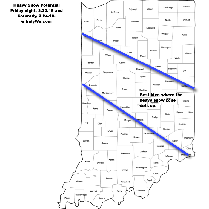
Just south of where the heaviest band of snow sets up, a period of sleet and freezing rain is also possible before a cold rain falls far downstate. Precipitation will end from northwest to southeast Saturday night and the weekend will wrap up dry Sunday- when the heart of the state will be digging out from a significant snow event. We’ll continue to keep a close eye on things.
Permanent link to this article: https://indywx.com/2018/03/22/significant-weekend-winter-storm/
Mar 21
VIDEO: Weekend Winter Storm Brewing For Portions Of The State…
You must be logged in to view this content. Click Here to become a member of IndyWX.com for full access. Already a member of IndyWx.com All-Access? Log-in here.
Permanent link to this article: https://indywx.com/2018/03/21/video-weekend-winter-storm-brewing-for-portions-of-the-state/
Mar 21
Close Attention Warranted Friday Night-Saturday…
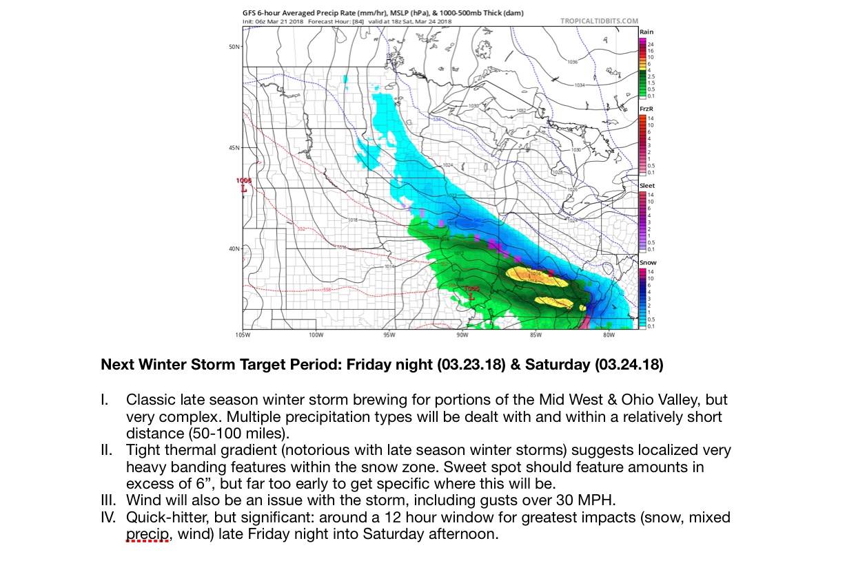
Just a quick update concerning some of our latest thinking around the next winter storm threat Friday night & Saturday. We’ll have a full update later this evening.
Permanent link to this article: https://indywx.com/2018/03/21/close-attention-warranted-friday-night-saturday/
Mar 20
Heavy Snow Targets Southern; Eastern Parts Of The State…
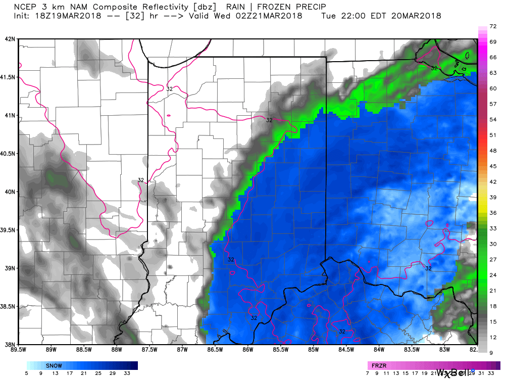
Snow will continue to expand across southern and eastern Indiana as we progress through the evening hours. Additionally, snowfall intensity will increase overall into the overnight hours across southeast Indiana.

Radar at 7:15p shows heavy snow across southern Indiana.
Our latest snowfall forecast is vastly unchanged from this morning, with the exception of expanding the 3″ to 6″ area a bit further west. Within this zone there will be a few reports of 8″ to 10″ before things wind down Wednesday afternoon.
 Snow will continue to fall through the overnight and into Wednesday morning before eventually diminishing across eastern parts of the state early Wednesday afternoon. At times, snow will be heavy and we continue to expect tough travel tonight into the daytime Wednesday across southern and eastern Indiana. When shoveling and cleaning things up Wednesday, remember this snow event will take on a heavy, wet characteristic.
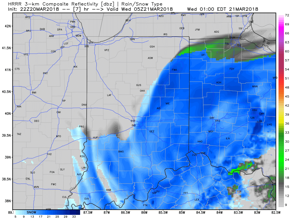
Forecast radar 1a, courtesy of weatherbell.com.

Forecast radar 8a, courtesy of weatherbell.com.
After a mostly dry and quiet time of things Wednesday afternoon and Thursday, our next storm system will approach Friday evening. This event will also have a wintry flavor to it and the potential is present for additional ice and snow accumulation Friday night into Saturday. If you have travel plans this weekend we recommend keeping close tabs on the forecast!
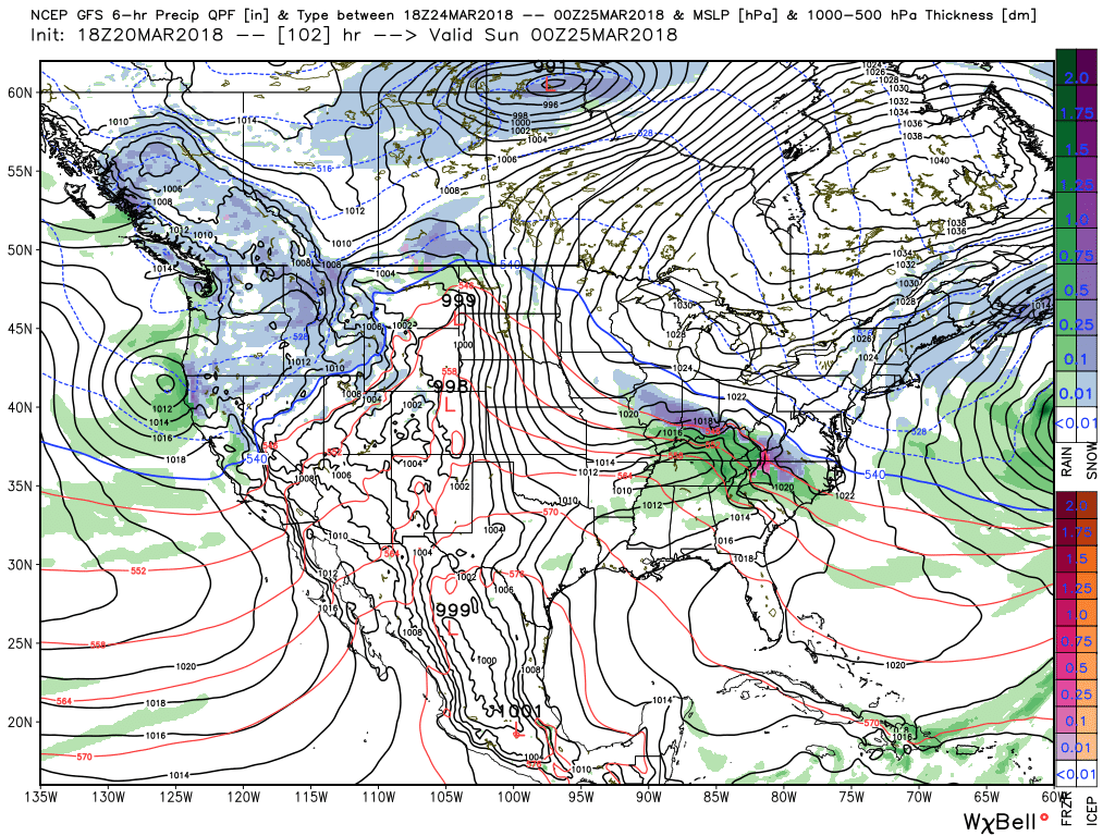 As mentioned in this morning’s video update, the longer range pattern is one that continues to suggest colder than average temperatures will rule the day. Until we can shake that negative NAO we don’t anticipate any major improvements in this pattern. Remember, we’re only the messenger… 🙂

Permanent link to this article: https://indywx.com/2018/03/20/heavy-snow-targets-southern-eastern-parts-of-the-state/
Mar 20
VIDEO: Snow Overspreads Southern; Eastern Indiana This Evening…
You must be logged in to view this content. Click Here to become a member of IndyWX.com for full access. Already a member of IndyWx.com All-Access? Log-in here.
Permanent link to this article: https://indywx.com/2018/03/20/video-snow-overspreads-southern-eastern-indiana-this-evening/
Mar 19
Wet Snow Event For East-Central Indiana…
Moisture will overspread the southern half of the state as we progress through the evening. Expect an increasingly damp time of things, especially from the I-70 corridor and points south through the overnight period. Eventually, as cold air oozes south, precipitation will become mixed with a wintry “cocktail” of sleet, freezing rain, and wet snow along the I-70 corridor during the overnight into the predawn hours Tuesday.
 While major travel problems aren’t expected, a slushy accumulation is possible along the I-70 stretch early Tuesday morning.
We’ll be in between systems and undergo a bit of a lull in the action during the majority of the daytime hours Tuesday. However, as upper level energy spins closer to the region, we’ll notice an expanding area of snow that will initially develop across south-central parts of the state Tuesday afternoon before encompassing eastern portions of the region Tuesday evening. During this time period, snowfall intensity will also begin to ramp up and we fully expect periods of wet heavy snow to fall through the nighttime into Wednesday morning across eastern Indiana.
 Our initial first-stab at accumulations includes a band of 3″ to 6″ amounts across far eastern parts of the state, and it’s within this zone that we’ll likely see a few 6″+ reports before things begin to wind down late Wednesday morning into the early afternoon. Somewhere between New Castle and Richmond very well may end up being the winner with this event.
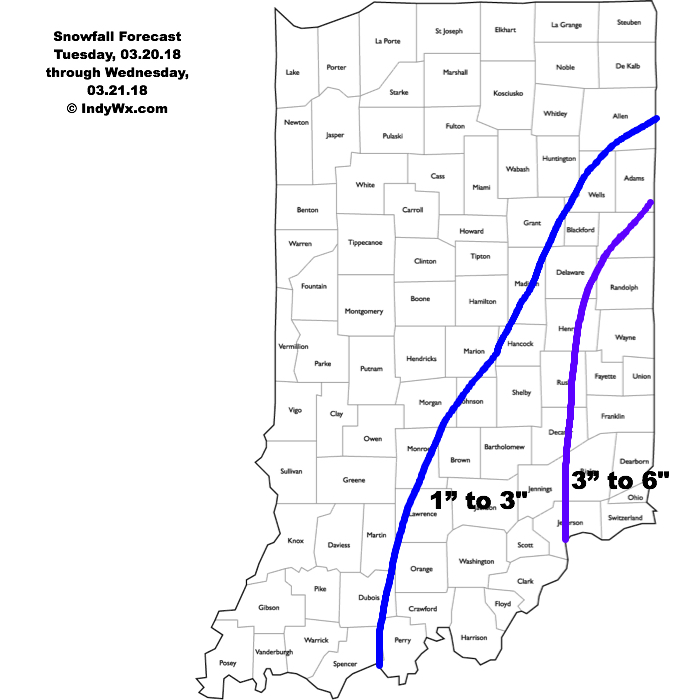 Given the unseasonably cold March ongoing, along with expected snowfall intensity, accumulation on roadways and travel problems are expected to develop Tuesday night into Wednesday morning across eastern Indiana. We recommend having travel completed before sunset Tuesday evening if your travels take you to, or through, far eastern Indiana.
As we’ve stated, March snow events always have “surprises.” While we try our best to eliminate as many of these surprises as possible, it’s simply the nature of the beast this time of year. Early spring snow events are notorious for producing localized intense bands of snow (more so than even high resolution models can show) given the right dynamics and time of day. Just something to keep in mind as we progress through the upcoming 24 to 48 hours.
Permanent link to this article: https://indywx.com/2018/03/19/wet-snow-event-for-east-central-indiana/
Mar 19
VIDEO: Accumulating Snow Impacts Parts Of The Area Tuesday-Wednesday…
You must be logged in to view this content. Click Here to become a member of IndyWX.com for full access. Already a member of IndyWx.com All-Access? Log-in here.
Permanent link to this article: https://indywx.com/2018/03/19/video-accumulating-snow-impacts-parts-of-the-area-tuesday-wednesday/
Mar 18
Brilliant Close To The Weekend; Wet Snow Thump For Some Early Week…
Though we were greeted with a cold and frosty start to our Sunday, high pressure will supply plentiful sunshine as we wrap up the St. Patrick’s Day weekend. Find a patio this afternoon that’s showing the Madness and soak up that Vitamin D. The increasingly powerful March sun angle will help boost temperatures into the middle to upper 50s for most of central Indiana.
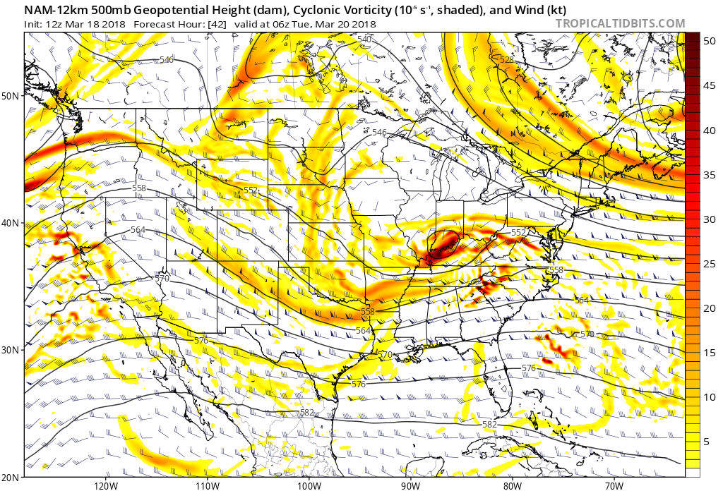
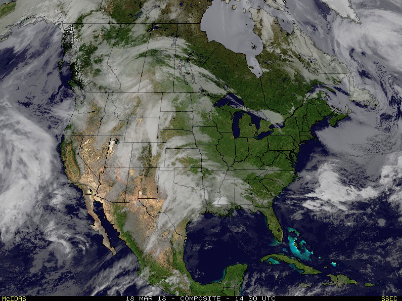 Things will begin to change as we open up a new work week. Surface low pressure will track out of the central Plains into the lower Ohio Valley Monday into Tuesday. This will spread moisture into the southern half of the state Monday evening. With air just cold enough, precipitation will mix with and perhaps change to a wintry mix of sleet and wet snow along the northern periphery of the precipitation overnight into Tuesday morning.
 March snow events can offer “surprises” and we’ll need to keep a close eye on the precise details pertaining to the track of the upper low Monday night into Tuesday. Under and just north of these little bundles of energy can often times be the spot for a wet snow “thump” this time of year. For now, it appears areas from southern IN into Ohio may be the sweet spot for a late season accumulating snow event.
 The mid week stretch should be showcased by dry, but unseasonably chilly conditions. Lows in the 20s and highs in the 40s aren’t what many Hoosiers on Spring Break want to deal with…
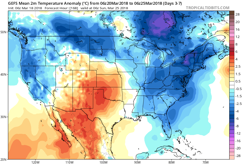 Our next item of significance arrives Friday as a warm front lifts northeast through the Ohio Valley. This will result in a wet close to the work week.
 Looking ahead, the weather pattern sure looks active to wrap up March and open April, including above average precipitation and potentially an “uptick” in severe weather episodes…

Permanent link to this article: https://indywx.com/2018/03/18/brilliant-close-to-the-weekend-wet-snow-thump-for-some-early-week/
Mar 17
VIDEO: Negative NAO’s Chilly Early April Impacts…
You must be logged in to view this content. Click Here to become a member of IndyWX.com for full access. Already a member of IndyWx.com All-Access? Log-in here.
Permanent link to this article: https://indywx.com/2018/03/17/video-negative-naos-chilly-early-april-impacts/
