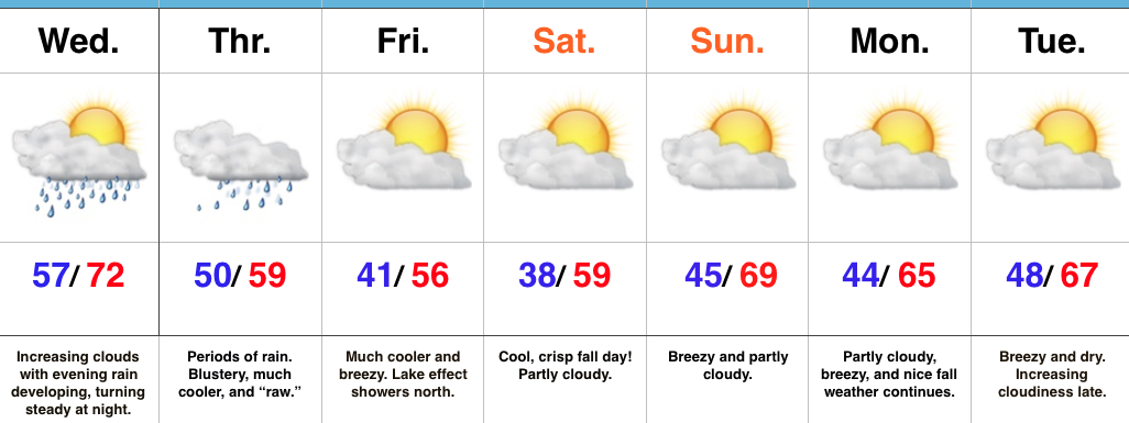
 Highlights:
- Wet weather moves in from south to north Wednesday PM
- Raw Thursday
- Much cooler, fall weather this weekend
Find The Rain Gear…Most of Wednesday will feature dry conditions with lots of sunshine to start, but clouds will be on the increase and rain will follow. We expect rain coverage to increase from south to north as evening gives way to nighttime. This is all in association with a surface low developing along a stationary boundary to our south. This area of low pressure will track along the Ohio River (Thursday) to the interior northeast (Friday). (Indiana snow enthusiasts know that’s a perfect track for the snowy “goods” if only it was a month, or so, later). We will continue to dream… 🙂
Back to regularly scheduled programming…
Rain will grow in coverage and intensity Wednesday night into early Thursday morning and periods of rain will be with us through the day Thursday. Heaviest rains should fall through the southern half of the state (where localized 2″+ totals are possible). The other weather element we’ll have to deal with Thursday is an increasingly chilly and raw northeast wind shifting to the north late. Temperatures will remain steady and slowly fall by evening.
As the area of low pressure pulls off to the northeast, it’ll help drive the coolest air of the season southward. Patchy frost is possible for outlying areas Saturday morning. Fall foliage should be looking “really nice” this weekend across central IN.
Dry, but breezy, conditions will be with us early next week, but we’re eyeing our next storm system by the middle to latter portions of the week.
Upcoming 7-Day Precipitation Forecast:
- Snowfall: 0.00″
- Rainfall: 1.00″ – 1.50″ (locally heavier amounts southeast)
