February 22, 2016 archive
This content is password protected. To view it please enter your password below: Password:
You must be logged in to view this content. Click Here to become a member of IndyWX.com for full access. Already a member of IndyWx.com All-Access? Log-in here.
Permanent link to this article: https://indywx.com/2016/02/22/client-long-range-video-discussion/
You must be logged in to view this content. Click Here to become a member of IndyWX.com for full access. Already a member of IndyWx.com All-Access? Log-in here.
Permanent link to this article: https://indywx.com/2016/02/22/monday-evening-video-update-7/
This content is password protected. To view it please enter your password below: Password:
You must be logged in to view this content. Click Here to become a member of IndyWX.com for full access. Already a member of IndyWx.com All-Access? Log-in here.
Permanent link to this article: https://indywx.com/2016/02/22/client-snow-discussion-2/
 Highlights:
- Nice open to the week
- Mid week winter storm for parts of the area
- Wind and heavy, wet snow
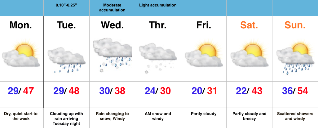
Mid Week Snow Storm For Parts Of The Area…Today is easy! Weak high pressure will supply dry skies and a quiet time of things, but trouble’s lurking for mid week.
Clouds will increase Tuesday and rain will move in Tuesday evening as a developing storm system lifts northeast out of Texas, into the TN Valley, and into the eastern Ohio Valley. Long term Hoosiers know that’s a classic track for a snow hit here across central IN and that will likely ring true for portions of the area Wednesday evening into Thursday. We forecast rain to transition to a heavy, wet snow from northeast to southwest Wednesday afternoon into the evening. There’s still fine tuning ahead, but as things stand now, this could be a significant event (6″+) for some central and northern IN neighborhoods. Stay tuned.
The other component of this storm will be a strong and gusty northeast wind that eventually shifts to the north and northwest Wednesday into Thursday. Cold conditions will be with us to wrap up the work week as the big dig begins for some.

Permanent link to this article: https://indywx.com/2016/02/22/mid-week-snow-storm-for-parts-of-the-area/
This content is password protected. To view it please enter your password below: Password:
You must be logged in to view this content. Click Here to become a member of IndyWX.com for full access. Already a member of IndyWx.com All-Access? Log-in here.
Permanent link to this article: https://indywx.com/2016/02/22/client-snow-discussion/


