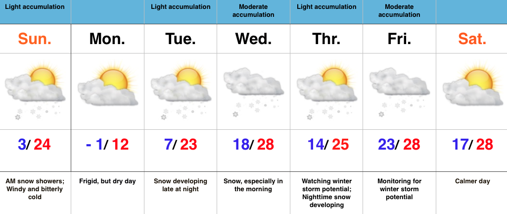
- Frigid stretch of weather
- Accumulating snow mid week
- Winter storm potential late week
Busy Winter Pattern…Frigid air is helping usher in the new week and this morning’s snow bursts are setting the tone for potentially “more important” snow events in the days to come.
First things first though and that’s today. Morning snow showers and heavier squalls will diminish and give way to an absolutely bitter feel for the afternoon. Highs today took place at midnight and will continue to plummet through the day. We’ll be in the single digits by dinner. Wind chill values tonight and Monday will reach 20 degrees below zero. Ouch!
All eyes will then shift to an approaching mid week snow maker and this should be a “plowable” event for most. We expect a swath of snow to roll through central IN late Tuesday night into Wednesday morning.
Just as soon as the mid week snow maker moves out, we’ll have to turn our attention to late week. There are many questions regarding the northward extent of snow with this storm, but the overall set-up from this distance has to put a smile on the faces of Ohio Valley snow lovers. The blocking high to the north will be sufficient to supply cold air at the surface as moisture is supplied from the Gulf of Mexico, but it will limit how far north the low will track. Is this an Ohio Valley or TN Valley event? Ensemble data at the moment leads us to believe this will track far enough north to impact our region. We’ll have to sort through additional details in the coming days.

